Old Maps of Baytown, Texas for Hiking & Exploration
Hike through history with 44 historic maps of Baytown. Explore old trails, ghost towns, and forgotten backroads — perfect for outdoor adventurers and local explorers.
- Rediscover forgotten places: Map out old mining camps, roads, and footpaths that no longer exist on modern maps.
- Layer with modern tools: Combine with LiDAR or satellite views to plan hikes through historical terrain.
- Made for exploration: Popular among hikers, overlanders, and local history lovers.
Use these maps to find adventure and explore the hidden past of Baytown.
Baytown, TX maps
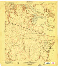
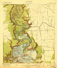
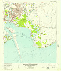
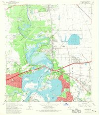
(44)- 1916 Map of Burnett Bay
 1916 Burnett Bay1916 Print · USGSCoastal Harris County is captured in the early twentieth century as the regional landscape began to modernize around the San Jacinto River. Researchers can trace the early layout of Lynchburg and Elena, locate rural landmarks like the Clawson School, and explore the grounds of the San Jacinto Battlefield.
 - 1916 Map of Morgan Point
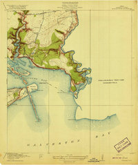
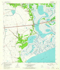
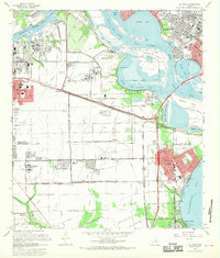
 1916 Morgan Point1916 Print · USGSCoastal Harris and Chambers counties are shown in the years following the opening of the ship channel, when ferries and family landmarks still defined the shoreline. Genealogists and researchers can trace early settlements and navigation aids, from the Goose Creek School and Goose Creek Ferry to the landing at Morgan Point.
 - 1916 Map of Cedar Bayou
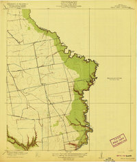
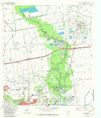
 1916 Cedar Bayou1916 Print · USGSThe coastal plains of Harris and Chambers counties are captured here just before the era of major regional change. Trace the early school at Ellis League School, find ferry crossings at Milam Bend, and follow the Barbers Hill Road through the bayou country.
 - 1916 Map of La Porte
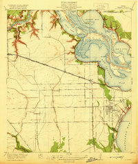
 1916 La Porte1916 Print · USGSCoastal Harris County is captured here during a period of rapid maritime and rail expansion just before the end of the Great War. Genealogists and historians can trace early property divisions and rail stops from Deer Park to the waters of Sylvan Beach and the San Jacinto Battlefield.2 unique versions available
 - 1919 Map of Morgan Point
 1919 Morgan Point1919 Print · USGSTexas's coastal industrial frontier comes to life just before the region's massive growth, showing the vital waterways of the bay. Trace the early footprints of Goose Creek, the railroad terminus at Bay Ridge, and the original Goose Creek School.2 unique versions available
 - 1919 Map of Cedar Bayou
 1919 Cedar Bayou1919 Print · USGSHarris County at the end of the Great War shows a transition from rural river life to an emerging road network. Genealogists and researchers can trace local landmarks like the Ellis League School and historical crossings such as Williams Ferry and Cedar Bayou.2 unique versions available
 - 1920 Map of La Porte
 1920 La Porte1920 Print · USGSCoastal Harris County is documented here during a period of industrial growth along the Houston Ship Channel. Researchers can trace the early rail networks of the Galveston Harrisburg and San Antonio RR and locate community landmarks like Lomax School and Sylvan Beach.3 unique versions available
 - 1920 Map of Highlands
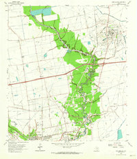
 1920 Highlands1920 Print · USGSHarris County at the dawn of the oil age reveals a landscape of tidal bayous and historic river crossings. Genealogists can locate family landmarks like Tory Hill, early education sites like Lynchburg School, and the hallowed grounds of the San Jacinto Battlefield.4 unique versions available
 - 1943 Map of West of Eagle
 1943 West of Eagle1943 Print · USGSCoastal Chambers County is captured here in the early 1940s along the western edge of Trinity Bay. Genealogists and local historians can trace family landmarks and early shoreline roads like Cedar Bayou Road and the Fisher Cem.
 - 1943 Map of Morgan Point
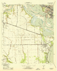
 1943 Morgan Point1943 Print · USGSThe coastal communities of Goose Creek, Baytown, and Pelly are shown in detail during the early 1940s as the regional maritime economy expanded. Researchers can trace the dual rail lines of the Southern Pacific and Missouri Pacific or locate local landmarks like the Hill of Rest Cem.
 - 1943 Map of Cedar Bayou, 1960 Print
 1943 Cedar Bayou1960 Print · USGSThe Gulf Coast oil and agriculture landscape comes alive in the 1940s as industry takes root near Mont Belvieu. Genealogists and historians can trace old family sites like Fisher Cem, Shiloh Ch, and the original Cedar Bayou Sch.
 - 1944 Map of La Porte
 1944 La Porte1944 Print · USGSCoastal Harris County is captured during the mid-forties, showing the vital maritime and rail corridors near the San Jacinto River. Genealogists and researchers can trace local landmarks like the La Porte Cem, the whistle-stop at Strang, and the recreational grounds of Sylvan Beach.
 - 1944 Map of Burnett Bay
 1944 Burnett Bay1944 Print · USGSCoastal Harris County during the mid-forties reveals a landscape of industrial expansion and historic river crossings. Genealogists and historians can trace family landmarks like the McGhee School and White Cem alongside the growing settlements of Highlands and Lynchburg.
 - 1950 Map of Houston, 1953 Print
 1950 Houston1953 Print · USGSCoastal Texas in the early fifties reveals a landscape of massive civil engineering and industrial transit. Genealogists and researchers can trace the growth of the Houston suburbs and the maritime infrastructure of Galveston Bay, including the Gulf Freeway and the Texas City Dike.
 - 1955 Map of Highlands, 1956 Print
 1955 Highlands1956 Print · USGSCoastal Harris County is seen here in the mid-fifties, dominated by industrial military sites and Texas revolutionary landmarks. Trace family roots at De Zavala Cem or locate the Battleship Texas and Lynchburg Ferry Landing near the river.
 - 1955 Map of La Porte, 1957 Print
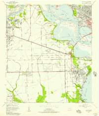 1955 La Porte1957 Print · USGSThe Harris County coastline was undergoing rapid industrial change in the mid-fifties as the Houston Ship Channel expanded. Trace early settlement patterns at Morgan Point, local schools like De Walt Sch, and the historic Sylvan Beach waterfront.
 - 1956 Map of Morgan Point, 1957 Print
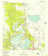
 1956 Morgan Point1957 Print · USGSCoastal Chambers and Harris Counties are shown here during a mid-century period of industrial and suburban development. Genealogists and local historians can locate the Morgan Point Cem, trace the Southern Pacific rail lines, and explore the sprawling Goose Creek Oil Field.3 unique versions available
 - 1956 Map of Houston, 1963 Print
 1956 Houston1963 Print · USGSSoutheast Texas in the mid-fifties is captured here as a powerhouse of oil and maritime trade. Genealogists and historians can trace the foundations of Houston and its ports, alongside landmarks like the Rice Institute and the Spindletop Oil Field.2 unique versions available
 - 1961 Map of Umbrella Point, 1964 Print
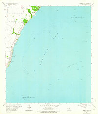 1961 Umbrella Point1964 Print · USGSCoastal Chambers County in the early sixties reveals a landscape defined by its connection to the sea and the rising petroleum industry. Researchers can find family burial grounds like Barrow Cem and Fisher Cem or trace the development of McCollum County Park and the nearby Tri-City Beach Mission.3 unique versions available
 - 1961 Map of Cove, 1964 Print
 1961 Cove1964 Print · USGSThe Texas coast near the Trinity River delta is captured here in the early sixties as industrial oil fields and a new interstate began to reshape the old marshlands. Genealogists can locate family landmarks such as Montgomery Cem, Icet Cem, and the Winfree Sch.3 unique versions available
 - 1961 Map of Mont Belvieu, 1964 Print
 1961 Mont Belvieu1964 Print · USGSCoastal Texas industry and settlement meet along the Harris-Chambers county line in the early sixties. Researchers can trace family history at Barbers Cem and Morgan Cem or explore the infrastructure of the Barbers Hill Oil Field.2 unique versions available
 - 1967 Map of Highlands, 1969 Print
 1967 Highlands1969 Print · USGSIn the late sixties, the confluence of the San Jacinto River and Buffalo Bayou served as both a heavy industrial hub and a site of state memory. Genealogists can trace family footprints in Lynchburg or McNair, while finding landmarks like the Battleship Texas and the Gospel Herald Ch.
 - 1967 Map of La Porte, 1970 Print
 1967 La Porte1970 Print · USGSCoastal Harris County in the late sixties shows a landscape where industrial shipping channels meet growing bayfront communities. Genealogists and local historians can trace residential patterns in Lomax, locate Betheny Cem, and see the early footprint of San Jacinto College.
 - 1975 Map of Houston, 1977 Print
 1975 Houston1977 Print · USGSThe Texas Gulf Coast in the mid-seventies shows a sprawling Houston metropolis linked to the sea by the massive Houston Ship Channel. Researchers can trace the mid-century industrial landscape from the Astrodome to the Lyndon B. Johnson Space Center.2 unique versions available
 - 1982 Map of Mont Belvieu
 1982 Mont Belvieu1982 Print · USGSThe industrial and residential growth of the Texas Gulf Coast is captured here in the early eighties. Genealogists and historians can trace family sites like Busch Cem and Fisher Cem or locate the sprawling Oil and Gas Field and refinery works.
Showing maps 1-25 of 44
Top cities near Baytown
- Houston historical maps
- Pasadena historical maps
- League City historical maps
- Channelview historical maps
- Texas City historical maps
- Friendswood historical maps
See more
Top neighborhoods of Baytown
- Pelly historical maps
- Wooster historical maps
- Brownwood historical maps
- Country Club Oaks historical maps
- Goose Creek Reserve historical maps
- Rolling Creek Estates historical maps
Frequently asked questions
- What are the different types of historical maps available for Baytown?
- What is the oldest map of Baytown?
- Where can I purchase historical maps of Baytown for my home or office?
- Where can I download high-res historical maps of Baytown?
- Are there historical topographic maps available for Baytown?
- Is there historical aerial imagery available for Baytown?
- Where are historical maps of Baytown sourced from?