1890s Maps of Hudspeth County, Texas
Explore 6 historic maps of Hudspeth County from the 1890s. These maps offer a rare glimpse into what life looked like during the 1890s — showing old roads, neighborhoods, homes, and landmarks that have changed or disappeared over time.
Whether you're researching your family's past, planning a metal detecting trip, or studying how Hudspeth County's landscape evolved across the 1890s, these high-resolution maps are a powerful tool for exploring the history of this region.
- Focus on a specific era: All maps on this page are from the 1890s, giving you a focused view of this time period.
- See what’s changed: Compare century-old streets, trails, and buildings to today's modern landscape using overlays and satellite layers.
- Research with precision: Use these maps for genealogy, historical research, land use analysis, or educational projects.
- View, download, or print: Maps are fully viewable online in high resolution, and can be downloaded or printed for your own records.
Start exploring Hudspeth County's history through authentic maps from the 1890s. This is your window into the past.
Hudspeth County, TX maps
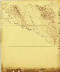
(6)- 1892 Map of Chispa, 1957 Print
 1892 Chispa1957 Print · USGSWest Texas railroad outposts and mountain passes are documented here in the final decade of the nineteenth century. Genealogists and historians can trace the early rail stops at Arno, Chispa, and Van Horn Wells along the original Southern Pacific line.
 - 1894 Map of Fort Hancock
 1894 Fort Hancock1894 Print · USGSWest Texas borderlands in the 1890s centered on the strategic military and rail corridor along the Rio Grande. Trace the early footprint of Fort Hancock Post and vanished outposts like Fort Quitman (Ab'd.) and Camp Rice (Ab'd.).4 unique versions available
 - 1895 Map of Chispa
 1895 Chispa1895 Print · USGSWest Texas rail travel was in its prime during the late nineteenth century as steam engines traversed the mountain passes. Genealogists and rail historians can trace early sidings and stops like Van Horns Wells, Chispa, and the natural crossing at Vieja Pass.
 - 1895 Map of Sierra Blanca
 1895 Sierra Blanca1895 Print · USGSThe Trans-Pecos rail junction at the end of the nineteenth century comes into focus on this sheet. Historians can trace early settlement patterns at Sierra Blanca and follow the routes of the Texas and Pacific Railroad and Southern Pacific Company.5 unique versions available
 - 1897 Map of Eagle Mountain
 1897 Eagle Mountain1897 Print · USGSThe Trans-Pecos frontier along the United States and Mexico border is captured here in the late nineteenth century. Researchers can trace the rugged terrain from Phinneys Ranch to the life-sustaining waters of Hot Spring and Eagle Spring.3 unique versions available
 - 1897 Map of Chispa
 1897 Chispa1897 Print · USGSWest Texas rail culture and high-desert landscapes take center stage in the 1890s as steam power bridges the vast distances between the Rio Grande and the interior mountains. Genealogists and historians can trace the early rail stops at Chispa and Dalberg, or locate the critical water source at Van Horn Wells.3 unique versions available
End of results
Showing maps 1-6 of 6
Top cities of Hudspeth County
Frequently asked questions
- What are the different types of historical maps available for Hudspeth County?
- What is the oldest map of Hudspeth County?
- Where can I purchase historical maps of Hudspeth County for my home or office?
- Where can I download high-res historical maps of Hudspeth County?
- Are there historical topographic maps available for Hudspeth County?
- Is there historical aerial imagery available for Hudspeth County?
- Where are historical maps of Hudspeth County sourced from?