Old Maps of Hudspeth County, Texas for Academic Research
Study the evolution of Hudspeth County with 256 high-resolution historic maps. Whether you're teaching, researching, or modeling changes in land use, these maps provide essential visual documentation of urban, environmental, and geographic change.
- Analyze long-term change: Track patterns in development, transportation, and natural features.
- Ideal for environmental or urban studies: Support academic projects with primary historical map data.
- Use in the classroom or lab: Educators and researchers rely on these maps to bring historical context to life.
These maps are a powerful tool for teaching, research, and visualizing how Hudspeth County has changed over the decades.
Hudspeth County, TX maps
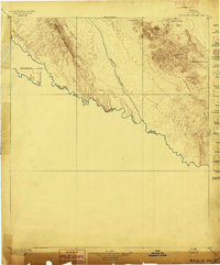
(256)- 1892 Map of Chispa, 1957 Print
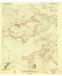
 1892 Chispa1957 Print · USGSWest Texas railroad outposts and mountain passes are documented here in the final decade of the nineteenth century. Genealogists and historians can trace the early rail stops at Arno, Chispa, and Van Horn Wells along the original Southern Pacific line.
 - 1894 Map of Fort Hancock
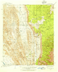
 1894 Fort Hancock1894 Print · USGSWest Texas borderlands in the 1890s centered on the strategic military and rail corridor along the Rio Grande. Trace the early footprint of Fort Hancock Post and vanished outposts like Fort Quitman (Ab'd.) and Camp Rice (Ab'd.).4 unique versions available
 - 1895 Map of Chispa
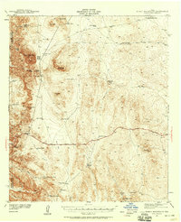
 1895 Chispa1895 Print · USGSWest Texas rail travel was in its prime during the late nineteenth century as steam engines traversed the mountain passes. Genealogists and rail historians can trace early sidings and stops like Van Horns Wells, Chispa, and the natural crossing at Vieja Pass.
 - 1895 Map of Sierra Blanca
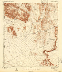
 1895 Sierra Blanca1895 Print · USGSThe Trans-Pecos rail junction at the end of the nineteenth century comes into focus on this sheet. Historians can trace early settlement patterns at Sierra Blanca and follow the routes of the Texas and Pacific Railroad and Southern Pacific Company.5 unique versions available
 - 1897 Map of Eagle Mountain
 1897 Eagle Mountain1897 Print · USGSThe Trans-Pecos frontier along the United States and Mexico border is captured here in the late nineteenth century. Researchers can trace the rugged terrain from Phinneys Ranch to the life-sustaining waters of Hot Spring and Eagle Spring.3 unique versions available
 - 1897 Map of Chispa
 1897 Chispa1897 Print · USGSWest Texas rail culture and high-desert landscapes take center stage in the 1890s as steam power bridges the vast distances between the Rio Grande and the interior mountains. Genealogists and historians can trace the early rail stops at Chispa and Dalberg, or locate the critical water source at Van Horn Wells.3 unique versions available
 - 1903 Map of Cerro Alto, 1929 Print
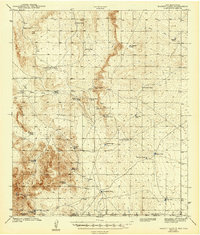
 1903 Cerro Alto1929 Print · USGSThe high desert of West Texas and the New Mexico border come alive in this turn-of-the-century survey. Trace early cattle-country water sources like Sparrow Tanks and Coyote Tanks or the peaks of the Hueco Mountains.
 - 1906 Map of Van Horn
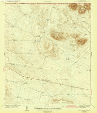
 1906 Van Horn1906 Print · USGSThe Trans-Pecos frontier is captured here at the turn of the century as the railroad and mining industry reshaped the high desert. Trace early family landholdings like Jones Ranch and Millican's Ranch, or locate historic operations like the Hazel Mine.5 unique versions available
 - 1916 Map of Eagle Mountain, 1929 Print
 1916 Eagle Mountain1929 Print · USGSThe Texas-Mexico borderlands come into sharp focus during the 1910s as cavalry units and cattle ranches define the high-desert landscape. Researchers can trace military movements at Troop A Crossing and locate historic outposts like Redlight Ranch and Old Bell Place.
 - 1933 Map of Guadalupe Peak
 1933 Guadalupe Peak1933 Print · USGSThe high desert of Culberson County meets the Texas peaks in the 1930s, documenting a landscape of remote ranching outposts and high-altitude mining. Genealogists and historians can trace family-named sites like Ables PO, Williams Ranch, and Sid Ables Well alongside early mountain retreats.6 unique versions available
 - 1935 Map of El Paso Gap, 1954 Print
 1935 El Paso Gap1954 Print · USGSThe Guadalupe Mountains of the mid-thirties are captured here as a landscape of isolated ranching outposts and vital water tanks. Genealogists and historians can trace family homesteads like Thayer Ranch and Carpenter Ranch, or locate the rural schoolhouses at Queen Sch and Dog Canyon Sch.2 unique versions available
 - 1936 Map of El Paso Gap
 1936 El Paso Gap1936 Print · USGSThe high desert ranching frontier along the New Mexico-Texas border is captured here during the mid-1930s. Researchers can locate remote schools and outposts like Queen Sch, the El Paso Gap PO, and family-named landmarks including Thayer Ranch.
 - 1940 Map of El Paso Gap
 1940 El Paso Gap1940 Print · USGSThe Guadalupe Mountains of southern New Mexico are shown in the mid-1930s, defined by a network of remote livestock ranches and isolated mountain schools. Genealogists and historians can trace family landholdings at Hepler Ranch or Lewis Ranch and locate vanished local landmarks like Queen Sch and the Old Post Place.3 unique versions available
 - 1940 Map of Guadalupe Peak, 1949 Print
 1940 Guadalupe Peak1949 Print · USGSCulberson County ranching and the high peaks of West Texas are captured here in the decade before the national park's founding. Genealogists and historians can trace family landholdings like Williams Ranch, Hegler Ranch, and the remote settlement at Frijole.2 unique versions available
 - 1940 Map of Bassett Lake, 1954 Print
 1940 Bassett Lake1954 Print · USGSThe high desert of Otero County at the start of the 1940s reveals a landscape organized around vital water sources and remote ranching outposts. Researchers can trace the network of desert storage like Camaleche Tanks and Escondida Tank or locate the site of Foster Ranch.
 - 1941 Map of Heuco Mountains, 1958 Print
 1941 Heuco Mountains1958 Print · USGSThe rugged Hueco Mountains of West Texas are captured here in the early 1940s, showing a landscape defined by ranching and historic travel routes. Trace the historic Butterfield Trail and locate family landmarks like Helms Ranch and Hueco Inn.2 unique versions available
 - 1942 Map of Borrego
 1942 Borrego1942 Print · USGSHigh desert ranching and mining operations in Hudspeth County are documented here in the early 1940s. Researchers can locate named water improvements and local industry sites like the Old Padre Mine, Minnie Veale Well, and Cunningham Tank.3 unique versions available
 - 1943 Map of Fort Quitman
 1943 Fort Quitman1943 Print · USGSThe Texas-Mexico borderlands along the Rio Grande are captured here in the early 1940s, showing a landscape of irrigation canals and mountain mines. Genealogists and historians can locate remote landmarks like Fort Quitman, the Bonanza Mine, and family sites such as Neeley Ranch.
 - 1943 Map of Tepee Butte
 1943 Tepee Butte1943 Print · USGSHudspeth County rangeland is captured here in the early 1940s, highlighting the vital water sources and remote outposts of the Trans-Pecos. Researchers can trace the layout of the Lee Moore Ranch and locate critical landmarks like Tepee Butte and Hobo Well.2 unique versions available
 - 1943 Map of San Antonio Mtn
 1943 San Antonio Mtn1943 Print · USGSThe Trans-Pecos desert frontier comes into focus in the early 1940s as ranchers and travelers navigated this borderland terrain. Genealogists and historians can trace isolated landmarks like Byers Ranch, the local Landing Field, and dozens of vital water catchments like Double Tank.
 - 1943 Map of Heuco Mountains
 1943 Heuco Mountains1943 Print · USGSHudspeth County ranching and desert travel come into focus in the early 1940s as modern highways began to parallel historic wagon routes. Researchers can locate remote family sites like Helms Ranch and Helm Cem or trace the path of the Butterfield Road.
 - 1943 Map of Finlay Mountains
 1943 Finlay Mountains1943 Print · USGSHudspeth County’s high-desert landscape comes alive in the early 1940s, showing the intersection of heavy rail and remote ranching life. Genealogists and historians can trace the paths of the Southern Pacific railroad through old stops like Madden and Finlay, or locate isolated homesteads like Wilkie Ranch.
 - 1943 Map of Fort Hancock
 1943 Fort Hancock1943 Print · USGSThe Rio Grande borderlands of West Texas during the early 1940s reveal a landscape of desert ranching and intensive river-fed irrigation. Genealogists and historians can trace rail-side settlements like Acala and Fort Hancock alongside the intricate Young Drain and McNary Main Canal systems.2 unique versions available
 - 1943 Map of Bassett Lake
 1943 Bassett Lake1943 Print · USGSThe arid high desert of Otero County and the Texas border are captured here during the early war years. Genealogists and desert historians can trace early ranching sites like Foster Ranch and numerous family-named landmarks including John Key Tank and Roberts Tank.
 - 1943 Map of McNary
 1943 McNary1943 Print · USGSHudspeth County agriculture and rail transit converge along the river valley in the early 1940s. Trace the irrigation network of the Hudspeth Main Canal and the twin rail lines near McNary and the Hudspeth Farm Camp.
Showing maps 1-25 of 256
Top cities of Hudspeth County
Frequently asked questions
- What are the different types of historical maps available for Hudspeth County?
- What is the oldest map of Hudspeth County?
- Where can I purchase historical maps of Hudspeth County for my home or office?
- Where can I download high-res historical maps of Hudspeth County?
- Are there historical topographic maps available for Hudspeth County?
- Is there historical aerial imagery available for Hudspeth County?
- Where are historical maps of Hudspeth County sourced from?