1950s Maps of Hudspeth County, Texas
Explore 10 historic maps of Hudspeth County from the 1950s. These maps offer a rare glimpse into what life looked like during the 1950s — showing old roads, neighborhoods, homes, and landmarks that have changed or disappeared over time.
Whether you're researching your family's past, planning a metal detecting trip, or studying how Hudspeth County's landscape evolved across the 1950s, these high-resolution maps are a powerful tool for exploring the history of this region.
- Focus on a specific era: All maps on this page are from the 1950s, giving you a focused view of this time period.
- See what’s changed: Compare century-old streets, trails, and buildings to today's modern landscape using overlays and satellite layers.
- Research with precision: Use these maps for genealogy, historical research, land use analysis, or educational projects.
- View, download, or print: Maps are fully viewable online in high resolution, and can be downloaded or printed for your own records.
Start exploring Hudspeth County's history through authentic maps from the 1950s. This is your window into the past.
Hudspeth County, TX maps
(10)- 1951 Map of Dell City, 1952 Print
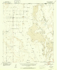 1951 Dell City1952 Print · USGSHudspeth County ranching and the vast salt flats are captured here in the early fifties as irrigation began to transform the basin. Researchers can trace the Butterfield Trail, find remote outposts like List Ranch, and locate the Salt Flat Airfield.2 unique versions available
 - 1951 Map of Red Hills, 1952 Print
 1951 Red Hills1952 Print · USGSThe ranching and utility corridors of Hudspeth County are captured here in the early fifties as the region relied on complex water management. Researchers can locate remote outposts like Scratch Ranch and Adobe House alongside the Hueco Pumping Station.
 - 1954 Map of Carlsbad, 1963 Print
 1954 Carlsbad1963 Print · USGSSoutheastern New Mexico's desert peaks and river valleys appear in this mid-century study of the borderlands. Researchers can locate vanished sites like Sacramento City, trace the Pecos River reservoirs, and explore Carlsbad Caverns.3 unique versions available
 - 1954 Map of Van Horn, 1964 Print
 1954 Van Horn1964 Print · USGSThe Trans-Pecos region of West Texas comes into focus in the mid-1950s as a vital corridor of rail and desert commerce. Researchers can trace the path of the Texas and Pacific through Van Horn or locate remote rail sidings like Borracho and Laska Siding.2 unique versions available
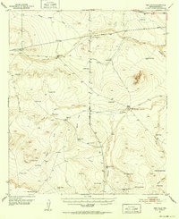
 - 1955 Map of Cerro Diablo, 1956 Print
 1955 Cerro Diablo1956 Print · USGSThe Trans-Pecos ranching landscape of the mid-1950s is frozen in time across this Hudspeth County borderland. Genealogists and historians can trace family operations like Mayfield Ranch and Schnaubert Ranch alongside landmarks like Cerro Diablo.
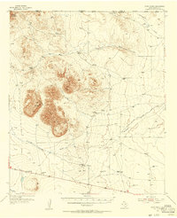
 - 1955 Map of Black Mountains, 1956 Print
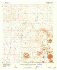
 1955 Black Mountains1956 Print · USGSMid-century Hudspeth County was a landscape of remote ranching outposts and vital water sources at the edge of the desert. Researchers can trace family-named sites and infrastructure like Babb Camp, Big Tank Ranch, and the Salt Flat Airfield.
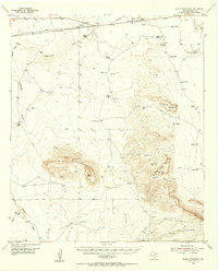
 - 1958 Map of Van Horn
 1958 Van Horn1958 Print · USGSWest Texas ranching and rail history come alive in this 1950s survey of the Trans-Pecos desert during the era of major steam-to-diesel transition. Genealogists and historians can trace family-named outposts like Mayfield Ranch or locate the ruins of Presidio Viejo along the Rio Grande.
 - 1958 Map of Carlsbad
 1958 Carlsbad1958 Print · USGSSoutheastern New Mexico in the mid-1950s shows a landscape of deep desert basins and high forest ranges during a period of steady ranching and early tourism. Researchers can trace the path of the Atchison Topeka and Santa Fe railroad or find vanished locales like Sacramento City (abandoned) and Whites City.2 unique versions available
 - 1959 Map of Alamo Mountain, 1960 Print
 1959 Alamo Mountain1960 Print · USGSThe Chihuahuan Desert borderlands of New Mexico and Texas come alive in this mid-century survey of ranching and mountain peaks. Researchers can locate remote family holdings like Wimberly Ranch and Lee Ranch, or trace the arid hydrology of Alamo Spring and Cowan Lake.2 unique versions available
 - 1959 Map of Marfa, 1976 Print
 1959 Marfa1976 Print · USGSThe Trans-Pecos frontier is captured here in the mid-twentieth century as cattle ranching and high-altitude science shaped the landscape. Researchers can trace the Southern Pacific rail line through Valentine or locate remote border outposts like Ruidosa and Indian Hot Springs Resort.2 unique versions available
End of results
Showing maps 1-10 of 10
Top cities of Hudspeth County
Frequently asked questions
- What are the different types of historical maps available for Hudspeth County?
- What is the oldest map of Hudspeth County?
- Where can I purchase historical maps of Hudspeth County for my home or office?
- Where can I download high-res historical maps of Hudspeth County?
- Are there historical topographic maps available for Hudspeth County?
- Is there historical aerial imagery available for Hudspeth County?
- Where are historical maps of Hudspeth County sourced from?