1920s Maps of Reeves County, Texas
Explore 4 historic maps of Reeves County from the 1920s. These maps offer a rare glimpse into what life looked like during the 1920s — showing old roads, neighborhoods, homes, and landmarks that have changed or disappeared over time.
Whether you're researching your family's past, planning a metal detecting trip, or studying how Reeves County's landscape evolved across the 1920s, these high-resolution maps are a powerful tool for exploring the history of this region.
- Focus on a specific era: All maps on this page are from the 1920s, giving you a focused view of this time period.
- See what’s changed: Compare century-old streets, trails, and buildings to today's modern landscape using overlays and satellite layers.
- Research with precision: Use these maps for genealogy, historical research, land use analysis, or educational projects.
- View, download, or print: Maps are fully viewable online in high resolution, and can be downloaded or printed for your own records.
Start exploring Reeves County's history through authentic maps from the 1920s. This is your window into the past.
Reeves County, TX maps
(4)- 1921 Map of Toyah
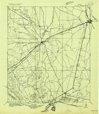 1921 Toyah1921 Print · USGSReeves County at the dawn of the highway era is documented here, showing the junction of major rail lines and early transcontinental motor routes. Researchers can trace family ranching history and railroad development through Toyah, Saragosa, and the VR Ranch.
 - 1925 Map of Orla 2-b
 1925 Orla 2-b1925 Print · USGSThe Pecos River valley at the Texas and New Mexico border comes to life in this mid-1920s survey. Researchers can trace the early rail corridor of the Panhandle and Santa Fe or locate landmarks like the Orla School and Olds Ranch.
 - 1928 Map of Kent
 1928 Kent1928 Print · USGSWest Texas ranching and rail life at the end of the 1920s are captured here as the region transitioned toward modern highway travel. Genealogists and historians can trace early outposts like Kent, family ranch sites such as Diamond Ranch, and the route of the Old Spanish Trail.
 - 1929 Map of Hovey
 1929 Hovey1929 Print · USGSIn the Trans-Pecos during the late twenties, the railroad and early motor trails dictated the rhythm of life across the mesa country. Researchers can trace the path of the Old Spanish Trail, locate rural stops like Chancellor, and identify family landmarks like Hayter and Williams.
End of results
Showing maps 1-4 of 4
Top cities of Reeves County
Frequently asked questions
- What are the different types of historical maps available for Reeves County?
- What is the oldest map of Reeves County?
- Where can I purchase historical maps of Reeves County for my home or office?
- Where can I download high-res historical maps of Reeves County?
- Are there historical topographic maps available for Reeves County?
- Is there historical aerial imagery available for Reeves County?
- Where are historical maps of Reeves County sourced from?