1980s Maps of Reeves County, Texas
Explore 10 historic maps of Reeves County from the 1980s. These maps offer a rare glimpse into what life looked like during the 1980s — showing old roads, neighborhoods, homes, and landmarks that have changed or disappeared over time.
Whether you're researching your family's past, planning a metal detecting trip, or studying how Reeves County's landscape evolved across the 1980s, these high-resolution maps are a powerful tool for exploring the history of this region.
- Focus on a specific era: All maps on this page are from the 1980s, giving you a focused view of this time period.
- See what’s changed: Compare century-old streets, trails, and buildings to today's modern landscape using overlays and satellite layers.
- Research with precision: Use these maps for genealogy, historical research, land use analysis, or educational projects.
- View, download, or print: Maps are fully viewable online in high resolution, and can be downloaded or printed for your own records.
Start exploring Reeves County's history through authentic maps from the 1980s. This is your window into the past.
Reeves County, TX maps
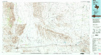
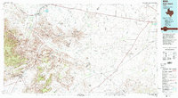
(10)- 1980 Map of Cox Draw
 1980 Cox Draw1980 Print · USGSReeves County in the 1970s was a land of high-desert ranching and emerging energy interests. Researchers can trace the essential water network of the day through named landmarks like Sheep Shearing Windmill, Sandia, and Elkins Hills.
 - 1980 Map of Balmorhea
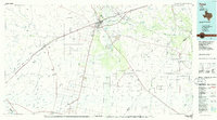
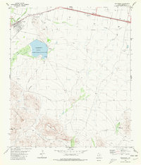 1980 Balmorhea1980 Print · USGSIn the Trans-Pecos desert during the early 1980s, Balmorhea and Brogado relied on a sophisticated network of canals and reservoirs. Genealogists and historians can trace the irrigation systems around Balmorhea Lake and locate the local Cem and Athletic Field.
 - 1980 Map of Barrilla Mountains East
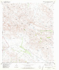
 1980 Barrilla Mountains East1980 Print · USGSThe high-desert terrain of the Trans-Pecos comes into focus during the late seventies, where the Barrilla Mountains meet at a three-county boundary. Researchers can trace ranching footprints through remote landmarks like South Camp and isolated water sources like Wagon Windmill.
 - 1980 Map of Barrilla Mountains West, 1981 Print
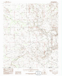
 1980 Barrilla Mountains West1981 Print · USGSThe Jeff Davis and Reeves County border country is documented in the 1980s, showcasing a landscape defined by ranching and mountain terrain. Researchers can trace family-named water sources and landmarks like Mc Camey Windmill, Hernandez Windmill, and Carpenter Mountain.
 - 1985 Map of Guadalupe Peak
 1985 Guadalupe Peak1985 Print · USGSCulberson County and the rugged Trans-Pecos region are shown in the mid-1980s as a landscape of massive peaks and desert draws. Researchers can trace the historic Butterfield Trail, locate the Old Michigan Mine, and explore the high country of Guadalupe Peak.
 - 1985 Map of Red Bluff
 1985 Red Bluff1985 Print · USGSThe Pecos River valley at the New Mexico-Texas border is captured here during the mid-eighties, showing a landscape defined by water engineering and ranching infrastructure. Researchers can trace land use through features like Rock House Crossing, East Apple Tank, and the northern reaches of the Red Bluff Reservoir.
 - 1985 Map of Van Horn
 1985 Van Horn1985 Print · USGSFar West Texas comes into focus in the mid-1980s as a high-desert crossroads for rail and ranching. Genealogists and historians can trace the Southern Pacific line through Van Horn, locate the settlement of Kent, and explore landmarks like Seven Heart Gap.3 unique versions available
 - 1985 Map of Fort Davis, 1994 Print
 1985 Fort Davis1994 Print · USGSWest Texas in the mid-eighties shows a landscape of high desert peaks and vital spring-fed irrigation. Trace the development of Toyahvale and Balmorhea, or locate specific landmarks like the Fort Davis National Historic Site and Robbers Roost.2 unique versions available
 - 1986 Map of Kermit
 1986 Kermit1986 Print · USGSWest Texas during the mid-eighties was a landscape defined by the energy industry and the winding Pecos River. Trace the development of Oil Field networks near Kermit, the historic Horsehead Crossing, and the rail lines of the Missouri Pacific.2 unique versions available
 - 1986 Map of Pecos
 1986 Pecos1986 Print · USGSWest Texas in the mid-eighties reveals a landscape of desert draws and growing energy infrastructure centered on the Pecos River. Researchers can trace old rail lines, family burials at Mount Evergreen Cem, and rural outposts like Toyah or Saragosa.2 unique versions available
End of results
Showing maps 1-10 of 10
Top cities of Reeves County
Frequently asked questions
- What are the different types of historical maps available for Reeves County?
- What is the oldest map of Reeves County?
- Where can I purchase historical maps of Reeves County for my home or office?
- Where can I download high-res historical maps of Reeves County?
- Are there historical topographic maps available for Reeves County?
- Is there historical aerial imagery available for Reeves County?
- Where are historical maps of Reeves County sourced from?