1940s Maps of Zapata County, Texas
Explore 5 historic maps of Zapata County from the 1940s. These maps offer a rare glimpse into what life looked like during the 1940s — showing old roads, neighborhoods, homes, and landmarks that have changed or disappeared over time.
Whether you're researching your family's past, planning a metal detecting trip, or studying how Zapata County's landscape evolved across the 1940s, these high-resolution maps are a powerful tool for exploring the history of this region.
- Focus on a specific era: All maps on this page are from the 1940s, giving you a focused view of this time period.
- See what’s changed: Compare century-old streets, trails, and buildings to today's modern landscape using overlays and satellite layers.
- Research with precision: Use these maps for genealogy, historical research, land use analysis, or educational projects.
- View, download, or print: Maps are fully viewable online in high resolution, and can be downloaded or printed for your own records.
Start exploring Zapata County's history through authentic maps from the 1940s. This is your window into the past.
Zapata County, TX maps
(5)- 1940 Map of Aguilares
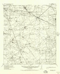 1940 Aguilares1940 Print · USGSSouth Texas ranching and the early oil industry meet in the late 1930s along the Texas Mexican Railroad. Local historians can trace family landholdings from Zapata Ranch to Dodier Ranch, or locate commerce hubs like Pullin Store and the Magnolia Pump Station.
 - 1940 Map of Randado
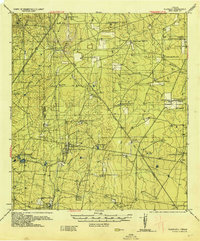 1940 Randado1940 Print · USGSJim Hogg County ranchlands and oil fields are captured here in the late thirties just before the war. Researchers can trace family landholdings like De La Garza Ranch and Armstrong Ranch or locate early industrial sites at the Randado Oil Field.
 - 1940 Map of Mogotes Hill
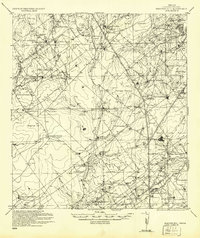 1940 Mogotes Hill1940 Print · USGSZapata County ranching and early petroleum discovery meet in the brush country during the 1940s. Genealogists and historians can trace family landholdings from Trinidad Ranch to Bella Vista Ranch, while locating early industry at Escobas Field and the Cuellar Store.
 - 1942 Map of San Ygnacio, 1956 Print
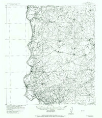 1942 San Ygnacio1956 Print · USGSZapata County ranchlands along the Mexican border appear here just as the region’s traditional ways were being documented by military surveyors. You can trace early family holdings and river life at San Ygnacio, the Ferry crossing, and the historic Dolores Ruins.
 - 1949 Map of Mc Allen, 1954 Print
 1949 Mc Allen1954 Print · USGSThe Rio Grande Valley at mid-century reveals a bustling international corridor of citrus groves, rail lines, and growing border towns. Genealogists and historians can trace the Missouri Pacific RR through McAllen or locate rural landmarks like the Santa Fe School and Arkansas City.
End of results
Showing maps 1-5 of 5
Top cities of Zapata County
Frequently asked questions
- What are the different types of historical maps available for Zapata County?
- What is the oldest map of Zapata County?
- Where can I purchase historical maps of Zapata County for my home or office?
- Where can I download high-res historical maps of Zapata County?
- Are there historical topographic maps available for Zapata County?
- Is there historical aerial imagery available for Zapata County?
- Where are historical maps of Zapata County sourced from?