1960s Maps of Zapata County, Texas
Explore 5 historic maps of Zapata County from the 1960s. These maps offer a rare glimpse into what life looked like during the 1960s — showing old roads, neighborhoods, homes, and landmarks that have changed or disappeared over time.
Whether you're researching your family's past, planning a metal detecting trip, or studying how Zapata County's landscape evolved across the 1960s, these high-resolution maps are a powerful tool for exploring the history of this region.
- Focus on a specific era: All maps on this page are from the 1960s, giving you a focused view of this time period.
- See what’s changed: Compare century-old streets, trails, and buildings to today's modern landscape using overlays and satellite layers.
- Research with precision: Use these maps for genealogy, historical research, land use analysis, or educational projects.
- View, download, or print: Maps are fully viewable online in high resolution, and can be downloaded or printed for your own records.
Start exploring Zapata County's history through authentic maps from the 1960s. This is your window into the past.
Zapata County, TX maps
(5)- 1962 Map of McAllen
 1962 McAllen1962 Print · USGSThe Lower Rio Grande Valley in the mid-twentieth century shows a complex landscape of irrigation, oil production, and border commerce. Genealogists and historians can trace family roots through riverside towns like Zapata, Roma-Los Saenz, and Hidalgo, or locate landmarks like Santa Elena Ch and Moore Air Force Base.
 - 1965 Map of Salineno, 1968 Print
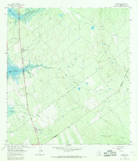
 1965 Salineno1968 Print · USGSThe Texas-Mexico borderlands come into focus in the mid-1960s, showing the early infrastructure surrounding the river and the reservoir. Genealogists can trace family sites at Salineño and Los Arrierous Cem or locate old ranching outposts like Margo.2 unique versions available
 - 1965 Map of Falcon Village, 1968 Print
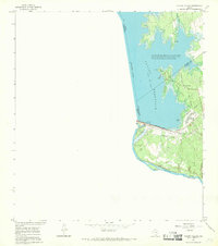 1965 Falcon Village1968 Print · USGSThe mid-sixties Rio Grande borderlands are defined here by the waters of Falcon Reservoir and the rise of Falcon Village. Researchers can trace the international boundary and locate features like Chapeno Cem and the Falcon Dam.
 - 1965 Map of Lopeno, 1968 Print
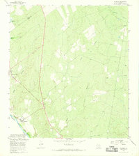
 1965 Lopeno1968 Print · USGSSouth Texas brush country and the rising waters of the Rio Grande meet in the mid-sixties as energy production reshapes the borderlands. Genealogists and historians can trace the grid of the Lopeño Gas Field and old settlements like Lopeño and Falcon.
 - 1965 Map of Beckwith Arm, 1968 Print
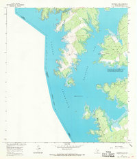 1965 Beckwith Arm1968 Print · USGSFalcon Reservoir defined this borderland in the mid-1960s, its rising waters creating a new landscape for recreation and industry. Researchers can trace the development of the Lopeno Gas Field and find early recreational landmarks like the Marina and Trailer Camp and Landing Strip.2 unique versions available
End of results
Showing maps 1-5 of 5
Top cities of Zapata County
Frequently asked questions
- What are the different types of historical maps available for Zapata County?
- What is the oldest map of Zapata County?
- Where can I purchase historical maps of Zapata County for my home or office?
- Where can I download high-res historical maps of Zapata County?
- Are there historical topographic maps available for Zapata County?
- Is there historical aerial imagery available for Zapata County?
- Where are historical maps of Zapata County sourced from?