1990s Maps of Davis County, Utah
Explore 24 historic maps of Davis County from the 1990s. These maps offer a rare glimpse into what life looked like during the 1990s — showing old roads, neighborhoods, homes, and landmarks that have changed or disappeared over time.
Whether you're researching your family's past, planning a metal detecting trip, or studying how Davis County's landscape evolved across the 1990s, these high-resolution maps are a powerful tool for exploring the history of this region.
- Focus on a specific era: All maps on this page are from the 1990s, giving you a focused view of this time period.
- See what’s changed: Compare century-old streets, trails, and buildings to today's modern landscape using overlays and satellite layers.
- Research with precision: Use these maps for genealogy, historical research, land use analysis, or educational projects.
- View, download, or print: Maps are fully viewable online in high resolution, and can be downloaded or printed for your own records.
Start exploring Davis County's history through authentic maps from the 1990s. This is your window into the past.
Davis County, UT maps
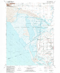
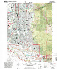
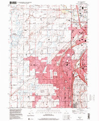
(24)- 1990 Map of Roy
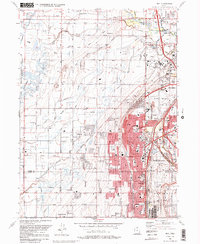 1990 Roy1990 Print · USGSThe corridor between Ogden and Clinton is shown here in the 1990s, defined by its massive military installations and expanding suburban grid. Researchers can trace local landmarks like Clinton Cem, the Ogden Municipal Airport, and the former Old Railroad Grade.2 unique versions available
 - 1991 Map of Fremont Island
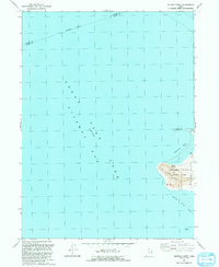
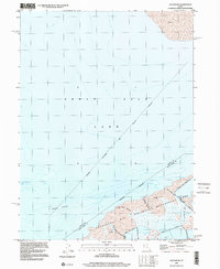
 1991 Fremont Island1991 Print · USGSThe Great Salt Lake in the early nineties features the prominent Fremont Island and its surrounding bays. Local history enthusiasts can trace the Lucin Cutoff rail line or locate the Ruins Graves and David E Miller Hill.
 - 1991 Map of Fremont Island SW
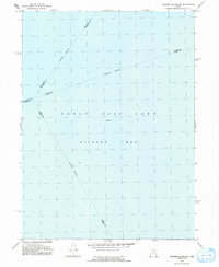 1991 Fremont Island SW1991 Print · USGSThe waters of Gilbert Bay are the primary focus of this late-century survey of the Great Salt Lake. Researchers can trace the convergence of several underwater county lines, including the Weber Co Davis Co and Davis Co Tooele Co boundaries.
 - 1991 Map of Clearfield
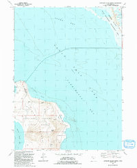
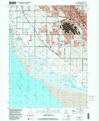
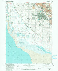 1991 Clearfield1991 Print · USGSDavis County's shoreline meets industrial expansion in the early nineties, showing a landscape defined by water management and military presence. Researchers can trace the sprawling Freeport Center, family roots at West Point Cemetery, and the intricate path of the Hooper Aqueduct.2 unique versions available
 - 1991 Map of Ogden Bay
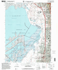
 1991 Ogden Bay1991 Print · USGSThe Weber River delta in the early nineties shows a fascinating mix of managed wetlands and rural Utah settlements. Trace the agricultural layout of Hooper and West Warren, or locate historic sites like Hales Bend and the local Cem.
 - 1991 Map of Buffalo Point
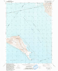
 1991 Buffalo Point1991 Print · USGSAntelope Island and the surrounding waters of the Great Salt Lake are captured here during the early nineties. Researchers can trace the shoreline and island landmarks including Buffalo Spring, the heights of Buffalo Point, and Egg Island.
 - 1991 Map of Antelope Island North
 1991 Antelope Island North1991 Print · USGSThe southeastern Great Salt Lake comes into focus in the early nineties, centered on the northern reaches of Antelope Island. Genealogists and historians can trace the landscape from Bennet to the State Waterfowl Management Area.
 - 1991 Map of Peterson, 1992 Print
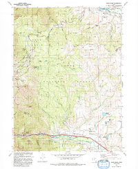
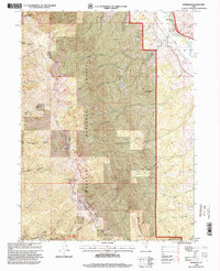
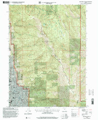
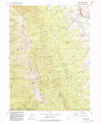 1991 Peterson1992 Print · USGSMorgan Valley and the high Wasatch ridgeline meet in the early nineties, showing a landscape defined by the river and the forest boundary. Genealogists and hikers can locate the Peterson Cem, the high Francis Peak, and historic resource sites like the Sunset Mine.
 - 1992 Map of Snow Basin
 1992 Snow Basin1992 Print · USGSThe high alpine bowls and Weber Valley settlements are captured here in the early nineties as recreation and local infrastructure expanded. Researchers can trace family sites at Mountain Green, locate the Mtn Green Cemetery, or explore the development of Snow Basin.
 - 1992 Map of Ogden
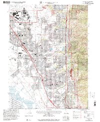
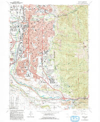 1992 Ogden1992 Print · USGSThe Ogden area in the early nineties shows a thriving urban corridor bordered by the peaks of the Wasatch Range. Genealogists and historians can trace the development of Weber State University, the sprawling Defense Depot Ogden, and many local schools including St Josephs High Sch.2 unique versions available
 - 1992 Map of Kaysville
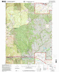
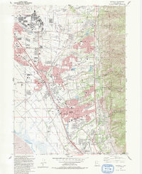 1992 Kaysville1992 Print · USGSThe Wasatch Front underwent significant suburban expansion in the early nineties, centered on the military and agricultural hubs of Davis County. Researchers can trace local development through landmarks like Hill Air Force Base, Layton Sta, and Lakeview Cemetery.2 unique versions available
 - 1997 Map of Saltair NE, 2001 Print
 1997 Saltair NE2001 Print · USGSThe Davis County shoreline and Great Salt Lake transition zone are captured here in the late nineties, showcasing the region's managed wetlands. Environmental researchers and local historians can trace the paths of Crystal Creek and the Salt Lake City Sewage Canal through the Waterfowl Management Area.
 - 1997 Map of Baileys Lake, 2001 Print
 1997 Baileys Lake2001 Print · USGSThe wetlands of the Great Salt Lake are captured here in the late nineties, showing a landscape of hunting clubs and water management. Trace the Old Railroad Grade and find historic sites like Riter and the Harrison Duck Club.
 - 1998 Map of Peterson, 2000 Print
 1998 Peterson2000 Print · USGSMorgan Valley and the high ridges of the Wasatch Range are captured here just before the millennium. Researchers can trace family history at the Peterson Cem or locate historical landmarks like Francis Peak and the Military Springs Reservation.
 - 1998 Map of Farmington, 2001 Print
 1998 Farmington2001 Print · USGSThe eastern shore of the Great Salt Lake comes into focus in the late nineties as suburban growth reaches the mountain foothills. Genealogists and local historians can trace the development of Farmington, Lagoon, and schools like Reading Sch and Stewart Sch.
 - 1998 Map of Salt Lake City North, 2001 Print
 1998 Salt Lake City North2001 Print · USGSSalt Lake City and its northern neighbors appear at the end of the century as the region prepared for the 2002 Winter Olympics. Researchers can trace the massive industrial and transport hubs near Skypark Airport or locate civic landmarks like the State Capitol and the historic Pony Exp Mon.
 - 1998 Map of Mountain Dell, 2001 Print
 1998 Mountain Dell2001 Print · USGSThe high passes and historic migration trails east of Salt Lake City are preserved here in the late nineties. Trace the footsteps of the Mormon Pioneers and locate landmark markers like the Ephraim Hanks Station Pony Express Marker or the Camp Grant Hist Site.
 - 1998 Map of Fort Douglas, 2001 Print
 1998 Fort Douglas2001 Print · USGSThe eastern edges of Salt Lake City and Bountiful meet the high Wasatch front in the late nineties, just as the region prepared for the Winter Olympics. Researchers can trace the boundaries of Fort Douglas, find the City Cemetery, and see the footprint of the Olympic Village.
 - 1998 Map of Snow Basin, 2001 Print
 1998 Snow Basin2001 Print · USGSMorgan County is shown in the late 1990s as the high-elevation terrain prepared for the Olympic winter games. Researchers can trace the development of the Snowbasin Ski Area and locate local landmarks like Mountain Green and the Strawberry Mine.
 - 1998 Map of Ogden, 2001 Print
 1998 Ogden2001 Print · USGSOgden at the end of the millennium shows a bustling urban center transitioning into the peaks of the Wasatch Range. Researchers can trace family sites at City Cemetery and Uintah Cemetery or locate historic schools like Ben Lomond High Sch.
 - 1998 Map of Bountiful Peak, 2001 Print
 1998 Bountiful Peak2001 Print · USGSThe Wasatch Front near the turn of the millennium shows a bustling suburban landscape pressed against the steep mountain canyons. Researchers can trace local development through landmarks like Lakeview Hospital and the LDS Temple, or explore the high-country trails along Skyline Drive.
 - 1998 Map of Kaysville, 2001 Print
 1998 Kaysville2001 Print · USGSDavis County underwent rapid suburban transformation in the late nineties as residential neighborhoods filled the benchlands below the Wasatch Front. Genealogists and local historians can trace the development of Clearfield, Layton, and Kaysville alongside landmarks like Lakeview Cemetery and the Hill Air Force Base.
 - 1999 Map of Clearfield, 2001 Print
 1999 Clearfield2001 Print · USGSThe eastern shore of the Great Salt Lake comes into focus in the late nineties as residential growth meets major industrial hubs. Researchers can trace the massive Freeport Center, the borders of Hill Air Force Base, and the West Point Cemetery.
 - 1999 Map of Roy, 2001 Print
 1999 Roy2001 Print · USGSWeber County's growing suburban and military landscape is captured here during the late 1990s as cities like Roy and Clinton expand. Researchers can trace family history at Stoker Memorial Cemetery or locate landmarks like Hill Air Force Base and the Aerospace Museum.
End of results
Showing maps 1-24 of 24
Top cities of Davis County
- Layton historical maps
- Bountiful historical maps
- Kaysville historical maps
- Syracuse historical maps
- Clearfield historical maps
- Farmington historical maps
See more
Frequently asked questions
- What are the different types of historical maps available for Davis County?
- What is the oldest map of Davis County?
- Where can I purchase historical maps of Davis County for my home or office?
- Where can I download high-res historical maps of Davis County?
- Are there historical topographic maps available for Davis County?
- Is there historical aerial imagery available for Davis County?
- Where are historical maps of Davis County sourced from?