1980s Maps of Duchesne County, Utah
Explore 8 historic maps of Duchesne County from the 1980s. These maps offer a rare glimpse into what life looked like during the 1980s — showing old roads, neighborhoods, homes, and landmarks that have changed or disappeared over time.
Whether you're researching your family's past, planning a metal detecting trip, or studying how Duchesne County's landscape evolved across the 1980s, these high-resolution maps are a powerful tool for exploring the history of this region.
- Focus on a specific era: All maps on this page are from the 1980s, giving you a focused view of this time period.
- See what’s changed: Compare century-old streets, trails, and buildings to today's modern landscape using overlays and satellite layers.
- Research with precision: Use these maps for genealogy, historical research, land use analysis, or educational projects.
- View, download, or print: Maps are fully viewable online in high resolution, and can be downloaded or printed for your own records.
Start exploring Duchesne County's history through authentic maps from the 1980s. This is your window into the past.
Duchesne County, UT maps
(8)- 1980 Map of Vernal, 1982 Print
 1980 Vernal1982 Print · USGSThe Uintah Basin in the early 1980s reveals a unique landscape of deep-rooted settlements and emerging energy fields. Genealogists and historians can trace the foundations of Fort Duchesne and the Ouray National Wildlife Refuge alongside active sites like the Red Wash Oil and Gas Field.2 unique versions available
 - 1980 Map of Price, 1987 Print
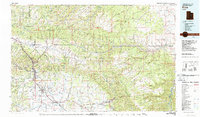 1980 Price1987 Print · USGSCarbon County in the early 1980s is defined by its deep canyons and intensive coal operations. Researchers can trace the rail spurs and mining works of the Denver and Rio Grande Western Railroad that connect Price, Helper, and the Sunnyside Mine.3 unique versions available
 - 1981 Map of Dutch John, 1982 Print
 1981 Dutch John1982 Print · USGSThe high Uinta plateau and the massive reservoir system appear here as they were in the early eighties. Local researchers can trace the roads connecting Manila and Greendale, or locate remote landmarks like the Dyer Mine and Spirit Lake.2 unique versions available
 - 1981 Map of Seep Ridge, 1982 Print
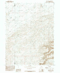
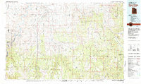 1981 Seep Ridge1982 Print · USGSEastern Utah at the start of the 1980s reveals a high-desert landscape of energy reserves and tribal lands. Researchers can trace the remnants of Watson (Site), the settlement at Rainbow, and the federal footprint of Naval Oil Shale Reserve No 2.2 unique versions available
 - 1982 Map of Kings Peak, 1985 Print
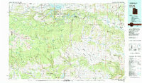
 1982 Kings Peak1985 Print · USGSThe high Uinta wilderness is captured in the early eighties, showing the intersection of three national forests at the Wyoming-Utah border. Hikers and historians can trace the high trails near Kings Peak, Moon Lake, and Iron Mine Mountain.2 unique versions available
 - 1982 Map of Duchesne, 1987 Print
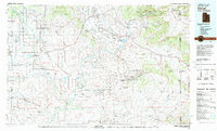
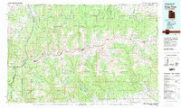
 1982 Duchesne1987 Print · USGSThe high plateaus and river basins of eastern Utah are captured here in the early 1980s, showcasing the region's vital water systems and tribal lands. Researchers can trace the development of the Uintah and Ouray Indian Reservation and locate old crossroads like Tabiona and Upalco.
 - 1985 Map of Crow Knoll
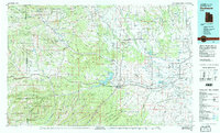
 1985 Crow Knoll1985 Print · USGSThe Duchesne and Uintah county line in the 1980s reveals a desert landscape adapted for ranching and resource extraction. Researchers can trace infrastructure like the Pipeline and find vital water sources including Kilroy Reservoir and Desert Spring.
 - 1985 Map of Duches Hole
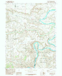 1985 Duches Hole1985 Print · USGSThe Green River serpentine loops through Uintah County in the 1980s, marking the transition from high plateaus to deep canyon country. Researchers can trace the intersection of the Naval Oil Shale Reserve No 2 and river landmarks like Duches Hole and Slough Grass Bottom.
End of results
Showing maps 1-8 of 8
Top cities of Duchesne County
- Roosevelt historical maps
- Duchesne historical maps
- Myton historical maps
- Altamont historical maps
- Tabiona historical maps
Frequently asked questions
- What are the different types of historical maps available for Duchesne County?
- What is the oldest map of Duchesne County?
- Where can I purchase historical maps of Duchesne County for my home or office?
- Where can I download high-res historical maps of Duchesne County?
- Are there historical topographic maps available for Duchesne County?
- Is there historical aerial imagery available for Duchesne County?
- Where are historical maps of Duchesne County sourced from?