1960s Maps of Duchesne County, Utah
Explore 80 historic maps of Duchesne County from the 1960s. These maps offer a rare glimpse into what life looked like during the 1960s — showing old roads, neighborhoods, homes, and landmarks that have changed or disappeared over time.
Whether you're researching your family's past, planning a metal detecting trip, or studying how Duchesne County's landscape evolved across the 1960s, these high-resolution maps are a powerful tool for exploring the history of this region.
- Focus on a specific era: All maps on this page are from the 1960s, giving you a focused view of this time period.
- See what’s changed: Compare century-old streets, trails, and buildings to today's modern landscape using overlays and satellite layers.
- Research with precision: Use these maps for genealogy, historical research, land use analysis, or educational projects.
- View, download, or print: Maps are fully viewable online in high resolution, and can be downloaded or printed for your own records.
Start exploring Duchesne County's history through authentic maps from the 1960s. This is your window into the past.
Duchesne County, UT maps
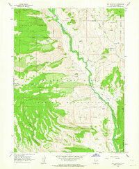
(80)- 1960 Map of Salt Lake City
 1960 Salt Lake City1960 Print · USGSThe Wasatch Front and High Uintas are captured mid-century as the Salt Lake Valley underwent significant postwar expansion. Genealogists and historians can trace rail lines like the Union Pacific and locate established landmarks such as Fort Douglas, Camp Williams, and the Bingham Canyon Mine.
 - 1960 Map of Price
 1960 Price1960 Print · USGSCentral Utah in the late fifties was a landscape of coal-hauling railroads and high plateau settlements. Genealogists and local historians can trace the rail-to-river economy from Price to the mountain mining camps of Hiawatha, Dragerton, and Sunnyside.2 unique versions available
 - 1960 Map of Vernal
 1960 Vernal1960 Print · USGSNortheastern Utah was a rugged frontier of mineral extraction and federal conservation in the mid-twentieth century. Genealogists and historians can trace the growth of Vernal, locate Gilsonite mining operations near Bonanza, and explore the 1950s boundaries of Dinosaur National Monument.
 - 1960 Map of Grand Junction
 1960 Grand Junction1960 Print · USGSThe Grand Junction area at the dawn of the 1960s shows a landscape of river-valley agriculture and high-plateau extraction. Researchers can trace the path of the dismantled railroad and find vanished sites like Watson and Sego.2 unique versions available
 - 1962 Map of Grand Junction
 1962 Grand Junction1962 Print · USGSThe Western Slope of the early sixties comes into focus here, showing the irrigation-driven growth of the valley and the surrounding high desert. Trace the path of the Denver and Rio Grande Western RR or locate old outposts like Atchee and Dragon.
 - 1962 Map of Price
 1962 Price1962 Print · USGSCentral Utah during the early sixties shows a landscape balancing high-mountain forestry with valley agriculture and coal mining. Genealogists and historians can trace the Denver and Rio Grande Western rail lines through industrial hubs like Price or locate formerly active sites like Coal City (abandoned).
 - 1962 Map of Deep Creek Canyon, 1963 Print
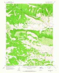
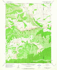 1962 Deep Creek Canyon1963 Print · USGSThe Wasatch and Duchesne county line was a high-country wilderness of deep drainages and pack routes in the early sixties. Researchers can trace the paths of old Jeep Trails and a Telephone line through Deep Creek Canyon and Wildcat Canyon.3 unique versions available
 - 1962 Map of Strawberry Pinnacles, 1963 Print
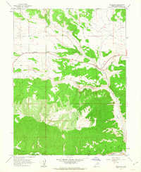
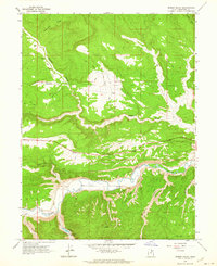
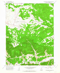 1962 Strawberry Pinnacles1963 Print · USGSThe Duchesne County high country is shown in detail in the early 1960s, centered on the dramatic Strawberry River corridor. Researchers can trace remote resource extraction at the Mines near Hoodoo Canyon or locate the namesake Strawberry Pinnacles formations.2 unique versions available
 - 1962 Map of Buck Knoll, 1963 Print
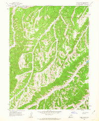
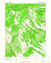
 1962 Buck Knoll1963 Print · USGSDuchesne County during the early 1960s is mapped here as a network of deep canyons and high plateaus as the regional energy industry began to take hold. Trace the early mining and drilling sites of the era, such as the Raven Mine and isolated Oil Wells near Indian Canyon.
 - 1962 Map of Sams Canyon, 1963 Print
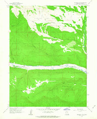
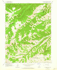
 1962 Sams Canyon1963 Print · USGSDuchesne County is captured in the early sixties as a remote landscape of mining and high-country canyon networks. Researchers can trace the legacy of resource extraction at the Frank Mine or locate early water sources like O'Driscoll Spring and Big Spring.3 unique versions available
 - 1962 Map of Blacktail Mtn, 1963 Print
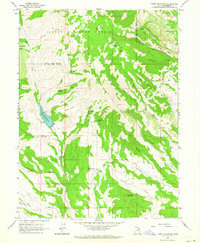
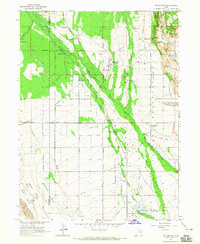
 1962 Blacktail Mtn1963 Print · USGSThe Uintah Basin in the early sixties is captured here, showing the intersection of reservation lands and high-country terrain. Trace the paths of early jeep trails and ranching infrastructure near Blacktail Mountain, Mcafee Ridge, and the Duchesne River.3 unique versions available
 - 1962 Map of Wolf Creek, 1963 Print
 1962 Wolf Creek1963 Print · USGSThe high Uinta Mountains were a wilderness of timber and water in the early sixties, split by the Wasatch and Duchesne county line. Trace the Old Indian Treaty Boundary or follow tracks to Tims Hole and Blue Lake.3 unique versions available
 - 1962 Map of Fruitland, 1963 Print
 1962 Fruitland1963 Print · USGSFruitland and the high Uinta Basin backcountry are captured here in the early sixties as a network of trails expanded across the desert. Search for family-named landmarks like Hayes Ponds, the local Cemetery, and the winding course of the Strawberry River.3 unique versions available
 - 1962 Map of Hanna, 1963 Print
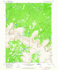
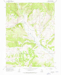 1962 Hanna1963 Print · USGSUpper Duchesne River country in the early sixties showcases a landscape divided between the Ashley National Forest and tribal lands. Researchers can trace the village of Hanna, the Stockmore Ranger Station, and rugged features like Wagon Road Ridge.3 unique versions available
 - 1962 Map of Tabiona, 1964 Print
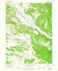 1962 Tabiona1964 Print · USGSThe Duchesne River valley in the early sixties was a landscape defined by ranching and complex irrigation. Genealogists and historians can trace the foundations of Tabiona and locate family landmarks like the Tabiona-Redcliff Cemetery, Wagstaff Hollow, and Little Valley.
 - 1962 Map of Rabbit Gulch, 1964 Print
 1962 Rabbit Gulch1964 Print · USGSIn the canyonlands of Duchesne County during the early 1960s, this area shows a landscape defined by the Strawberry River and high ridgelines. Researchers can trace old routes like the Telephone line and locate early industrial sites such as the Oil Well or localized landmarks like Pumphouse Spring.2 unique versions available
 - 1962 Map of Raspberry Knoll, 1964 Print
 1962 Raspberry Knoll1964 Print · USGSThe high-elevation boundary of Wasatch and Duchesne counties is captured in the early sixties, showing a landscape of forest preserves and emerging industry. Researchers can trace the Old Indian Treaty Boundary and locate a Mine and Oil Well near Bobby Duke Pass.2 unique versions available
 - 1962 Map of Strawberry Peak, 1964 Print
 1962 Strawberry Peak1964 Print · USGSThe Wasatch Range high country in the early sixties remains a wilderness of national forest lands and deep canyons. Researchers can trace the Old Indian Treaty Boundary and locate isolated landmarks like Twelve Hundred Dollar Ridge and the Oil Well near Jackson Hollow.
 - 1962 Map of Avintaquin Canyon, 1964 Print
 1962 Avintaquin Canyon1964 Print · USGSHigh desert canyons and remote ranchlands define this Duchesne County area in the early sixties. Genealogists and researchers can trace the Old Indian Treaty Boundary and locate early sites like Remund Ranch and Baum Ranch.
 - 1962 Map of Tabby Mountain, 1964 Print
 1962 Tabby Mountain1964 Print · USGSThe high Duchesne ridges of the early sixties are captured here, centered on the heights of Tabby Mountain and the Ashley National Forest. Researchers can trace the Old Indian Treaty Boundary or locate remote water sources like Whiskey Spring and Beer Spring.2 unique versions available
 - 1962 Map of Dry Mountain, 1964 Print
 1962 Dry Mountain1964 Print · USGSHigh in the Uintah Basin during the early 1960s, this survey documents a remote mountain landscape where forest and tribal lands meet. Researchers can trace the winding Rock Creek past the Indian Ranger Sta and locate secluded camps at Daniel Flat.3 unique versions available
 - 1962 Map of Farm Creek Peak, 1964 Print
 1962 Farm Creek Peak1964 Print · USGSThe high ridges and tribal lands of Duchesne County are captured here in the early 1960s, showing the intersection of forest and reservation. Researchers can trace the extensive irrigation network of the Jasper Canal or locate remote points like Round Grove and Tonigut Spring.
 - 1963 Map of Whiterocks Lake, 1964 Print
 1963 Whiterocks Lake1964 Print · USGSThe high Uinta basins of Daggett and Uintah counties are shown here in the early sixties, highlighting remote water systems and historical borders. Researchers can trace the Old Indian Treaty Boundary and locate early sites like Spirit Lake Campground or Whiterocks Lake.3 unique versions available
 - 1964 Map of Grand Junction
 1964 Grand Junction1964 Print · USGSThe Colorado-Utah borderlands are shown here in the mid-1960s, a period when the river-valley settlements and high-desert rail outposts defined the region. Researchers can trace the legacy of remote camps like Atchee and Dragon or follow the agricultural expansion around Grand Junction and Fruita.
 - 1964 Map of Whiterocks, 1965 Print
 1964 Whiterocks1965 Print · USGSThe Uinta Basin in the mid-1960s reveals a unique landscape of tribal lands and intensive irrigation. Researchers can trace family history at Hayden Cem or locate the Indian Sun Dance Grounds and Fort Robidoux Historical Monument.
Showing maps 1-25 of 80
Top cities of Duchesne County
- Roosevelt historical maps
- Duchesne historical maps
- Myton historical maps
- Altamont historical maps
- Tabiona historical maps
Frequently asked questions
- What are the different types of historical maps available for Duchesne County?
- What is the oldest map of Duchesne County?
- Where can I purchase historical maps of Duchesne County for my home or office?
- Where can I download high-res historical maps of Duchesne County?
- Are there historical topographic maps available for Duchesne County?
- Is there historical aerial imagery available for Duchesne County?
- Where are historical maps of Duchesne County sourced from?