1960s Maps of Iron County, Utah
Explore 4 historic maps of Iron County from the 1960s. These maps offer a rare glimpse into what life looked like during the 1960s — showing old roads, neighborhoods, homes, and landmarks that have changed or disappeared over time.
Whether you're researching your family's past, planning a metal detecting trip, or studying how Iron County's landscape evolved across the 1960s, these high-resolution maps are a powerful tool for exploring the history of this region.
- Focus on a specific era: All maps on this page are from the 1960s, giving you a focused view of this time period.
- See what’s changed: Compare century-old streets, trails, and buildings to today's modern landscape using overlays and satellite layers.
- Research with precision: Use these maps for genealogy, historical research, land use analysis, or educational projects.
- View, download, or print: Maps are fully viewable online in high resolution, and can be downloaded or printed for your own records.
Start exploring Iron County's history through authentic maps from the 1960s. This is your window into the past.
Iron County, UT maps
(4)- 1960 Map of Lund
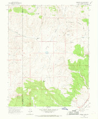
 1960 Lund1960 Print · USGSEastern Nevada and the Utah borderlands are mapped here during the mid-twentieth century, showing a landscape of high peaks and isolated ranching outposts. Researchers can locate remote mining sites like the Tungsten Queen Mine and early settlements including Lund and Shoshone.
 - 1962 Map of Cedar City
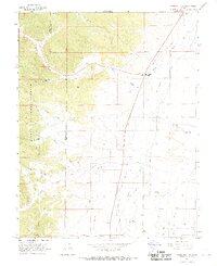
 1962 Cedar City1962 Print · USGSSouthern Utah in the early sixties showcases a landscape of dramatic plateaus and historic mining outposts. Trace the early settlement patterns at the Silver Reef (ruins), locate the Iron Mine near the Hurricane Cliffs, or find the Fort Harmony Monument.
 - 1966 Map of Fremont Pass, 1968 Print
 1966 Fremont Pass1968 Print · USGSThe high country along the Iron and Garfield County line is captured here in the mid-1960s, showing a remote landscape of trails and water holes. Genealogists and historians can trace the movement of early travel through Fremont Pass or locate isolated sites like the Radio Facility and Redcedar Spring.2 unique versions available
 - 1966 Map of Panguitch NW, 1969 Print
 1966 Panguitch NW1969 Print · USGSGarfield County’s high-desert valley comes alive in the mid-1960s, showing the intersection of ranching life and early irrigation systems. Genealogists and historians can trace family-named sites like Barton and Mc Ewen or the paths of the Panguitch Canal and Old State Canal.2 unique versions available
End of results
Showing maps 1-4 of 4
Top cities of Iron County
- Cedar City historical maps
- Enoch historical maps
- Parowan historical maps
- Paragonah historical maps
- Newcastle historical maps
- Kanarraville historical maps
See more
Frequently asked questions
- What are the different types of historical maps available for Iron County?
- What is the oldest map of Iron County?
- Where can I purchase historical maps of Iron County for my home or office?
- Where can I download high-res historical maps of Iron County?
- Are there historical topographic maps available for Iron County?
- Is there historical aerial imagery available for Iron County?
- Where are historical maps of Iron County sourced from?