1980s Maps of Iron County, Utah
Explore 23 historic maps of Iron County from the 1980s. These maps offer a rare glimpse into what life looked like during the 1980s — showing old roads, neighborhoods, homes, and landmarks that have changed or disappeared over time.
Whether you're researching your family's past, planning a metal detecting trip, or studying how Iron County's landscape evolved across the 1980s, these high-resolution maps are a powerful tool for exploring the history of this region.
- Focus on a specific era: All maps on this page are from the 1980s, giving you a focused view of this time period.
- See what’s changed: Compare century-old streets, trails, and buildings to today's modern landscape using overlays and satellite layers.
- Research with precision: Use these maps for genealogy, historical research, land use analysis, or educational projects.
- View, download, or print: Maps are fully viewable online in high resolution, and can be downloaded or printed for your own records.
Start exploring Iron County's history through authentic maps from the 1980s. This is your window into the past.
Iron County, UT maps
(23)- 1980 Map of Kolob Arch
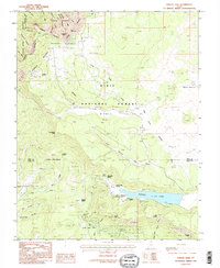
 1980 Kolob Arch1980 Print · USGSThe high plateau country of Washington County is captured here in the early eighties as it transitions from wild canyons to the arid west. Trace the historic Fort Harmony Monument, find the remote Kolob Arch, and follow the Lee Pass Trail through the backcountry.2 unique versions available
 - 1980 Map of Kolob Reservoir, 1981 Print
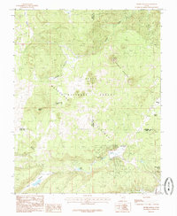
 1980 Kolob Reservoir1981 Print · USGSHigh-country canyons and reservoirs dominate this southwestern Utah landscape as it appeared in the early 1980s. Researchers can trace the borders of Zion National Park and find specific landmarks like Kolob Reservoir, Lava Point, and The Pillars.2 unique versions available
 - 1980 Map of Beaver, 1981 Print
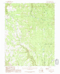
 1980 Beaver1981 Print · USGSSouthern Utah at the start of the 1980s reveals a rugged landscape of high mountain plateaus and essential desert irrigation networks. Researchers can trace the path of the Denver and Rio Grande Western through Marysvale or locate local landmarks like the Deer Trail Mine and Puffer Lake.2 unique versions available
 - 1980 Map of Panguitch, 1981 Print
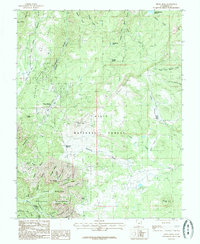
 1980 Panguitch1981 Print · USGSThe high plateau country of Southern Utah is captured here in the early eighties, centered on the Sevier River and the gateway town of Panguitch. Researchers can trace the boundaries of Bryce Canyon National Park and find local landmarks like Ruby's Inn, Panguitch Lake, and Hatch.2 unique versions available
 - 1980 Map of St. George, 1981 Print
 1980 St. George1981 Print · USGSThe St. George region underwent significant expansion in the early eighties as ranching traditions met new modern development. Researchers can trace the heritage of the Virgin River valley through sites like Grafton, the Apex Mine, and Snow Canyon State Park.2 unique versions available
 - 1980 Map of Kanab, 1981 Print
 1980 Kanab1981 Print · USGSSouthern Utah in the late seventies is a landscape of massive geologic terraces and isolated ranching towns. Trace the growth of Kanab and Springdale or locate vanished sites like Shunesburg among the White Cliffs and Vermilion Cliffs.
 - 1980 Map of Cogswell Point, 1982 Print
 1980 Cogswell Point1982 Print · USGSThe high plateau country of Southern Utah is captured here in the early 1980s, revealing the intersection of three counties and the edge of Zion. Researchers can locate remote high-altitude landmarks such as Volcano Knoll, the seasonal Virgin Flats, and the isolated Landing Strip at Burnt Flat.2 unique versions available
 - 1980 Map of Wah Wah Mts. South, 1984 Print
 1980 Wah Wah Mts. South1984 Print · USGSWestern Utah’s high desert and mineral-rich ranges are captured here in the late twentieth century, showing a landscape shaped by mining and the railroad. Researchers can locate remote shafts like the Wild Bill Mine, trace the Union Pacific Railroad through Lund, or explore the geography of the Wah Wah Mountains.2 unique versions available
 - 1982 Map of Wilson Creek Range
 1982 Wilson Creek Range1982 Print · USGSLincoln County mining districts and high-desert basins are captured here in the early eighties as the region balanced mineral production with early conservation. Researchers can trace historic industrial sites like the Atlanta Mine and Bristol Silver Mine or locate remote landmarks such as The Hermitage.
 - 1982 Map of Cedar City
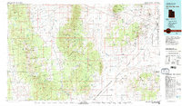
 1982 Cedar City1982 Print · USGSThe high desert and mountain ranges of southern Utah are captured here in the early eighties, from the growth of the foothills to remote rail sidings. Genealogists and historians can trace the paths between Cedar City, the desert junctions of Beryl Junction, and local landmarks like Quichapa Lake.
 - 1985 Map of Panguitch Lake
 1985 Panguitch Lake1985 Print · USGSSouthern Utah's high-elevation lake country is captured in the mid-eighties as a hub for forest recreation and ranching. Trace the development of Panguitch Lake and find remote landmarks like John L Flat, Miller Knoll, and Mammoth Spring.2 unique versions available
 - 1985 Map of Flanigan Arch
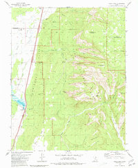
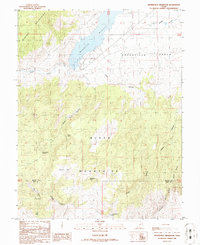
 1985 Flanigan Arch1985 Print · USGSIron County's high-country terrain is captured here in the mid-1980s, detailing a network of remote canyons and springs. Researchers can locate named landmarks like the Flanigan Arch, seasonal sites at Martins Flat, and the peaks of Summit Mountain.
 - 1985 Map of Navajo Lake
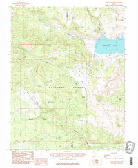
 1985 Navajo Lake1985 Print · USGSHigh on the Utah plateau in the mid-eighties, this landscape reveals the geological transition between volcanic craters and ancient sedimentary breaks. Researchers can trace alpine water sources like Navajo Lake and Cascade Falls alongside the high ridges of Cedar Breaks National Monument.2 unique versions available
 - 1985 Map of Henrie Knolls
 1985 Henrie Knolls1985 Print · USGSThe high Markagunt Plateau in the mid-1980s is captured here as a landscape of timber and hidden waters. Researchers can trace the unique drainage of Duck Creek Sinks and find seasonal landmarks like Aspen Mirror Lake, Cow Lake, and Bowers Flat.2 unique versions available
 - 1985 Map of Webster Flat
 1985 Webster Flat1985 Print · USGSThe high plateau of the Iron and Kane county line is documented here during the mid-eighties. Researchers can trace historic landmarks like Miners Peak, the waters of Aspen Lake, and several family-named overlooks including Sherratt Point and Bauer Point.2 unique versions available
 - 1985 Map of Brian Head, 1986 Print
 1985 Brian Head1986 Print · USGSIn the mid-1980s, the high alpine country around Brian Head was already a focal point for recreation and conservation. Trace the rugged boundaries of Cedar Breaks National Monument and find historic landmarks like the Quarry or Paradice Spring.
 - 1986 Map of Jack Henry Knoll
 1986 Jack Henry Knoll1986 Print · USGSSouthern Utah's high-desert landscape is captured here in the mid-eighties, showing the transition from the Black Mountains to the Parowan Valley. Researchers can trace remote water sources and backcountry landmarks like Jackrabbit Spring, Chipman Peak, and Poorman Canyon.
 - 1986 Map of Minersville Reservoir
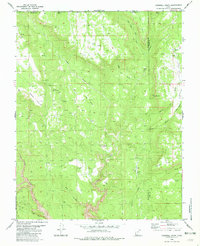
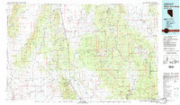
 1986 Minersville Reservoir1986 Print · USGSBeaver County and Iron County meet in the 1980s at the intersection of the Mineral Mountains and the Black Mountains. Researchers can trace water management and recreation history through the Minersville Reservoir, the Aberdare Canal, and the State Recreation Area.
 - 1986 Map of New Harmony, 1987 Print
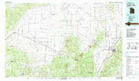
 1986 New Harmony1987 Print · USGSNew Harmony and the eastern edge of the Pine Valley Mountains are documented here during the late twentieth century. Researchers can trace land use and local geography through New Harmony, the Cem, and isolated landmarks like Siler Spring and Comanche Spring.2 unique versions available
 - 1989 Map of Badger Peak
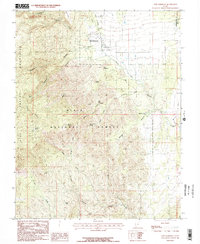
 1989 Badger Peak1989 Print · USGSThe high peaks and desert benches of Iron County are captured here in the late 1980s, revealing a landscape defined by water and terrain. Researchers can trace remote land use through features like the Corral and Hot Springs, or navigate the heights of Badger Peak.
 - 1989 Map of Dry Willow Peak
 1989 Dry Willow Peak1989 Print · USGSIron County, Utah, is shown in the late 1980s as a landscape of high-altitude drainages and essential water catchments. Researchers can trace land use through named features like Tebbs Pond, Dry Willow Peak, and the industrial site of a Gravel Pit.
 - 1989 Map of Thermo
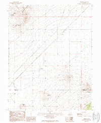 1989 Thermo1989 Print · USGSBeaver County at the end of the 1980s reveals a sparse desert landscape defined by rail and thermal springs. Genealogists and historians can trace the Union Pacific line through Thermo and locate remote water sources like Thermo Hot Springs and the Dead Horse Reservoir.
 - 1989 Map of Baboon Peak
 1989 Baboon Peak1989 Print · USGSIron County in the late eighties remains a landscape of high valleys and ranching outposts. Researchers can trace the water sources and land use patterns that sustained the area, from Baboon Seep and Marshall Pond to the high elevations of Baboon Peak.
End of results
Showing maps 1-23 of 23
Top cities of Iron County
- Cedar City historical maps
- Enoch historical maps
- Parowan historical maps
- Paragonah historical maps
- Newcastle historical maps
- Kanarraville historical maps
See more
Frequently asked questions
- What are the different types of historical maps available for Iron County?
- What is the oldest map of Iron County?
- Where can I purchase historical maps of Iron County for my home or office?
- Where can I download high-res historical maps of Iron County?
- Are there historical topographic maps available for Iron County?
- Is there historical aerial imagery available for Iron County?
- Where are historical maps of Iron County sourced from?