2000s (21st Century) Maps of Iron County, Utah
Explore 440 historic maps of Iron County from the 2000s (21st Century). These maps offer a rare glimpse into what life looked like during the 2000s — showing old roads, neighborhoods, homes, and landmarks that have changed or disappeared over time.
Whether you're researching your family's past, planning a metal detecting trip, or studying how Iron County's landscape evolved across the 2000s, these high-resolution maps are a powerful tool for exploring the history of this region.
- Focus on a specific era: All maps on this page are from the 2000s, giving you a focused view of this time period.
- See what’s changed: Compare century-old streets, trails, and buildings to today's modern landscape using overlays and satellite layers.
- Research with precision: Use these maps for genealogy, historical research, land use analysis, or educational projects.
- View, download, or print: Maps are fully viewable online in high resolution, and can be downloaded or printed for your own records.
Start exploring Iron County's history through authentic maps from the 2000s. This is your window into the past.
Iron County, UT maps
(440)- 2001 Map of Circleville Mountain, 2003 Print
 2001 Circleville Mountain2003 Print · USGSHigh in the Fishlake National Forest at the turn of the millennium, this area shows a landscape of mountain reservoirs and summer retreats. Researchers can trace historic grazing lands at Buck Pastures or locate remote camps like Fullmers Cabins and Kents Lake Campground.
 - 2001 Map of Kane Canyon, 2003 Print
 2001 Kane Canyon2003 Print · USGSBeaver and Iron Counties at the turn of the twenty-first century are defined by the high plateaus and canyon networks of the Fishlake National Forest. Researchers can trace the path of the Copes Dugway Trail and locate family-named landmarks like Patterson Creek and Beaver Ridge.
 - 2002 Map of Pinto, 2005 Print
 2002 Pinto2005 Print · USGSThe high country of the Dixie National Forest at the turn of the millennium reveals a landscape of isolated springs and historic burial sites. Researchers can locate the Hamblin Cem and trace the paths of Pinto Creek and Little Grassy Creek across the county line.
 - 2002 Map of Panguitch Lake, 2005 Print
 2002 Panguitch Lake2005 Print · USGSHigh-altitude water management and mountain ranching define this portion of the Dixie National Forest at the turn of the century. Researchers can trace the development of Panguitch Lake and locate family landmarks such as Miller Knoll or Cameron Troughs.
 - 2002 Map of Pinon Point, 2005 Print
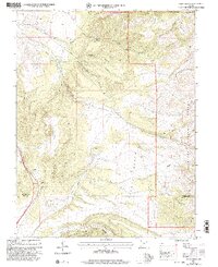
 2002 Pinon Point2005 Print · USGSIron County, Utah, remains a landscape defined by federal forest management and remote terrain at the turn of the millennium. Trace the high-altitude topography of Pinon Point and identify remote infrastructure like the Landing Strip or Sevy Hollow.
 - 2002 Map of Brian Head, 2005 Print
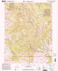
 2002 Brian Head2005 Print · USGSThe high plateau of Iron County comes into sharp focus during the early 2000s, showing the intersection of alpine recreation and protected wilderness. Researchers can trace the ski infrastructure at Brian Head, the natural formations of Cedar Breaks National Monument, and water features like Yankee Meadows Reservoir.
 - 2002 Map of Pine Park, 2005 Print
 2002 Pine Park2005 Print · USGSThe Utah and Nevada borderlands come into focus at the turn of the millennium, showing a landscape defined by state park boundaries and forest reserves. Local historians can trace cattle-era landmarks like Hamblin Ranch and crucial desert water sources such as Pine Park Spring and Schroeder Lake.
 - 2002 Map of Cottonwood Mountain, 2005 Print
 2002 Cottonwood Mountain2005 Print · USGSIron County in the early 2000s reveals a rugged landscape where the Dixie National Forest meets the Parowan Valley. Researchers can trace historic resource use through family-named landmarks like Elephant Rock, numerous prospects, and cattle-watering points such as Lower Cottonwood Troughs.
 - 2002 Map of Fivemile Ridge, 2005 Print
 2002 Fivemile Ridge2005 Print · USGSThe high backcountry of the Garfield and Iron County line is captured here during the late twentieth century. Researchers can trace the drainage patterns of Panguitch Creek or locate landmarks like Billy Spring and the Gaging Station.
 - 2002 Map of Webster Flat, 2005 Print
 2002 Webster Flat2005 Print · USGSThe high-plateau country of Iron County is mapped here at the start of the millennium, showing a landscape of deep canyons and prominent overlooks. Genealogists and hikers can trace family-named landmarks like Sherratt Point, Walts Flat, and Miners Peak across the Dixie National Forest.
 - 2002 Map of Page Ranch, 2005 Print
 2002 Page Ranch2005 Print · USGSSouthern Utah's iron-rich highlands are documented here at the turn of the millennium, showing a landscape defined by mining and early pioneer settlement. Researchers can locate the Old Irontown (Historic Site), trace the Rock Spring Trail, and identify the locations of the Columbia Steel Mine and Page Ranch.
 - 2002 Map of Mount Escalante, 2005 Print
 2002 Mount Escalante2005 Print · USGSIron County’s high-country terrain is captured here at the turn of the twenty-first century within the Dixie National Forest. Trace the landscape of the Pine Valley Ranger District and explore local landmarks like Mount Escalante and Sevy Hollow.
 - 2002 Map of Navajo Lake, 2005 Print
 2002 Navajo Lake2005 Print · USGSThe high plateau of Iron County during the early 2000s reveals a landscape of striking geological formations and alpine waters. Trace the winding Virgin River Rim Trail past Navajo Peak and explore the edges of Cedar Breaks National Monument.
 - 2002 Map of Little Creek Peak, 2005 Print
 2002 Little Creek Peak2005 Print · USGSIron and Garfield counties are mapped here at the start of the new millennium, showing the managed lands of the Dixie National Forest. Genealogists and historians can trace high-altitude water sources like Watercress Spring or locate the Quarries near Bear Creek.
 - 2002 Map of Panguitch NW, 2005 Print
 2002 Panguitch NW2005 Print · USGSGarfield County's high-country ranching and irrigation systems are preserved here in the early 2000s as the Sevier River valley transitions into forest land. Genealogists and historians can locate the local Cem, trace the Panguitch Canal, and identify old Quarries near Bear Valley Junction.
 - 2002 Map of Parowan, 2005 Print
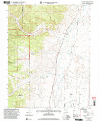
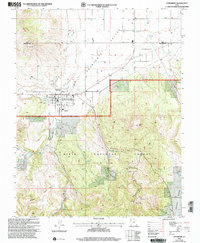
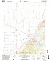
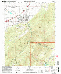 2002 Parowan2005 Print · USGSParowan sits at the foot of the Hurricane Cliffs during a period of steady growth in the high desert of Iron County. Researchers can trace the town's expansion toward the City Airport and locate landmarks like the Cem and Parowan High Sch.
 - 2002 Map of Enterprise, 2005 Print
 2002 Enterprise2005 Print · USGSEnterprise and the Escalante Valley are documented here in the early 2000s, showing the intersection of desert agriculture and high-country forest. Researchers can trace local heritage through landmarks like Winsor Mem Cem, Holt Cem, and the Enterprise High School.
 - 2002 Map of New Harmony, 2005 Print
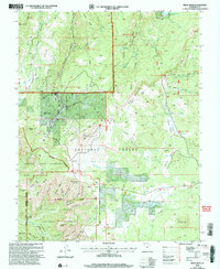
 2002 New Harmony2005 Print · USGSNew Harmony and the eastern slopes of the Pine Valley Mountains are documented in this early 2000s survey of the Dixie National Forest. Genealogists and researchers can locate the Cem, trace the Valley Trail, and identify landmarks like Mount Baldy and Comanche Spring.2 unique versions available
 - 2002 Map of Henrie Knolls, 2005 Print
 2002 Henrie Knolls2005 Print · USGSThe Markagunt Plateau at the turn of the millennium was a hub of forest management and high-country recreation. Map collectors and hikers can trace the Lost Hunter Trail, locate the Duck Creek Work Center, and study the unique Duck Creek Sinks.
 - 2002 Map of Red Creek Reservoir, 2005 Print
 2002 Red Creek Reservoir2005 Print · USGSThe high timber and mountain valleys of the Iron and Garfield county line are shown here in the early 2000s within the Dixie National Forest. Researchers can trace remote water sources and landmarks like the Red Creek Reservoir, Horse Valley Peak, and the curious Co-op Valley Sinks.
 - 2002 Map of Flanigan Arch, 2005 Print
 2002 Flanigan Arch2005 Print · USGSIron County, Utah, is shown at the start of the millennium, dominated by the protected peaks and deep drainages of the Dixie National Forest. Researchers can trace old mining prospects at various Adits or locate landmarks like Flanigan Arch and Sugarloaf Mountain.
 - 2002 Map of Hebron, 2005 Print
 2002 Hebron2005 Print · USGSThe area surrounding Hebron and the Dixie National Forest is shown here as it appeared at the turn of the millennium. Researchers can trace the layout of the Hebron Cem and examine the critical water systems of Lower Enterprise Reservoir and Upper Enterprise Reservoir.
 - 2002 Map of Newcastle, 2005 Print
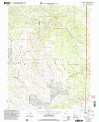
 2002 Newcastle2005 Print · USGSNewcastle and the southern Escalante Valley are seen here in the early 2000s, reflecting a landscape shaped by irrigation and high-desert ranching. Genealogists and local historians can locate the Newcastle Cem, Newcastle Reservoir, and various prospect sites along the forest edge.
 - 2002 Map of Uvada, 2005 Print
 2002 Uvada2005 Print · USGSCrossing the high-desert border at the turn of the millennium, this area shows the vital intersection of rail and water in a remote basin. Genealogists and rail historians can trace the Union Pacific line as it connects the settlements of Uvada and Crestline.
 - 2002 Map of Water Canyon, 2005 Print
 2002 Water Canyon2005 Print · USGSSouthern Utah's high country is captured here during the early 2000s, showing the intersection of Iron and Washington counties. Researchers can locate remote livestock landmarks like Rock Hole Corral and scattered backcountry water sources including Corral Dads Spring and Nephi Spring.
Showing maps 1-25 of 440
Top cities of Iron County
- Cedar City historical maps
- Enoch historical maps
- Parowan historical maps
- Paragonah historical maps
- Newcastle historical maps
- Kanarraville historical maps
See more
Frequently asked questions
- What are the different types of historical maps available for Iron County?
- What is the oldest map of Iron County?
- Where can I purchase historical maps of Iron County for my home or office?
- Where can I download high-res historical maps of Iron County?
- Are there historical topographic maps available for Iron County?
- Is there historical aerial imagery available for Iron County?
- Where are historical maps of Iron County sourced from?