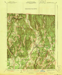
1940s Maps of Vermont
Explore 95 historic maps of Vermont from the 1940s. These maps offer a rare glimpse into what life looked like during the 1940s — showing old roads, neighborhoods, homes, and landmarks that have changed or disappeared over time.
Whether you're researching your family's past, planning a metal detecting trip, or studying how Vermont's landscape evolved across the 1940s, these high-resolution maps are a powerful tool for exploring the history of this region.
- Focus on a specific era: All maps on this page are from the 1940s, giving you a focused view of this time period.
- See what’s changed: Compare century-old streets, trails, and buildings to today's modern landscape using overlays and satellite layers.
- Research with precision: Use these maps for genealogy, historical research, land use analysis, or educational projects.
- View, download, or print: Maps are fully viewable online in high resolution, and can be downloaded or printed for your own records.
Start exploring Vermont's history through authentic maps from the 1940s. This is your window into the past.
Vermont maps
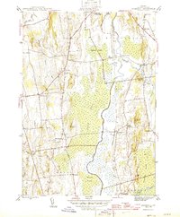
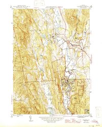
(95)- 1940 Map of Plainfield, 1953 Print
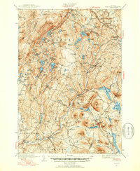 1940 Plainfield1953 Print · USGSVermont's hill country is captured here just before the war, showing a landscape defined by small farms and upland schools. Genealogists can locate family landmarks at Maple Cors Calais PO, Old West Ch, and the St Johnsbury and Lake Champlain RR.2 unique versions available
 - 1941 Map of Woodsville
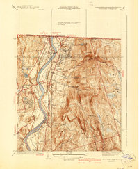
 1941 Woodsville1941 Print · USGSThe Connecticut River valley was a bustling corridor of granite quarries and rail junctions just before the war. You can trace the legacy of local industry and education through landmarks like Gibson Quarry, the County Poor Farm, and Town Farm Sch.4 unique versions available
 - 1941 Map of Bernardston
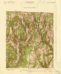
 1941 Bernardston1941 Print · USGSFranklin County's rural landscape is captured here in the early 1940s as rail lines still defined the local economy. Researchers can locate numerous district schools and historic family landmarks like Hales Crossing, West Gill, and the Sunnyside Sch.3 unique versions available
 - 1941 Map of Plattsburg
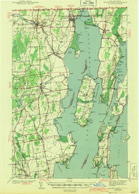
 1941 Plattsburg1941 Print · USGSLake Champlain was a critical corridor of military and transport activity in the years leading into the war. Researchers can trace the legacy of the Plattsburg Barracks, the winding Rutland rail line, and the geological site at Ausable Chasm.
 - 1941 Map of Northfield
 1941 Northfield1941 Print · USGSThe Connecticut River valley at the onset of the 1940s shows a landscape of busy rail lines and storied educational institutions. Genealogists and historians can trace Northfield landmarks like the Mt Hermon School, South Mtn Cem, and Schell Bridge.2 unique versions available
 - 1941 Map of Colrain
 1941 Colrain1941 Print · USGSThe hill towns of Franklin County appear here in the early 1940s, showing the tight-knit industrial and farming hamlets along the North River. Genealogists and historians can trace colonial-era frontier sites like the Site of Fort Morrison or locate family roots near Griswoldville and West Leyden.2 unique versions available
 - 1941 Map of Willsboro
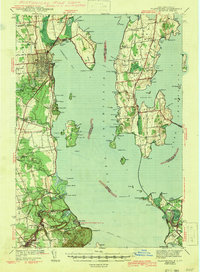
 1941 Willsboro1941 Print · USGSLake Champlain's shores in New York and Vermont are captured here just before the war, showing a landscape defined by lakefront landings and busy railroads. Trace the routes of the Delaware and Hudson and find local landmarks like Craterclub, Whallonsburg, and St Josephs Ch.2 unique versions available
 - 1942 Map of Keene
 1942 Keene1942 Print · USGSCheshire County at the start of the war shows a landscape of busy river valleys and upland farms. You can trace the path of the Boston & Maine RR through towns like Westmoreland and find old district landmarks like Sch No 10 or the Rand Cem.
 - 1943 Map of Willsboro
 1943 Willsboro1943 Print · USGSThe Lake Champlain shoreline in the early 1940s reveals a landscape of mountain-backed villages and vital cross-lake rail connections. Genealogists and researchers can trace local landmarks like St Josephs Ch, Lakeview Cem, and the path of the Delaware and Hudson railroad.3 unique versions available
 - 1943 Map of Plainfield
 1943 Plainfield1943 Print · USGSVermont's highland farming and rail communities are captured here in the 1940s as the state's rural landscape remained densely settled. Genealogists can locate family-named landmarks like Hollister Hill Sch, trace the Montpelier and Wells River RR, or find the Old West Ch near Kent Cors.2 unique versions available
 - 1943 Map of Rouses Point
 1943 Rouses Point1943 Print · USGSThe Lake Champlain borderlands in the early 1940s served as a critical international junction for rail and river transit between New York, Vermont, and Quebec. Researchers can trace historic family landmarks from Fort Montgomery to local schoolhouses like Rogers Sch and Barnes Sch.2 unique versions available
 - 1943 Map of St. Albans
 1943 St. Albans1943 Print · USGSFranklin County's shoreline and rail corridors are captured here during the early years of the war, showing the vital connection between Lake Champlain and the Canadian border. Researchers can trace the paths of the Central Vermont railroad through Swanton and St Albans, or locate rural landmarks like the Rock River Sch and Fonda Quarry.
 - 1943 Map of Plattsburg
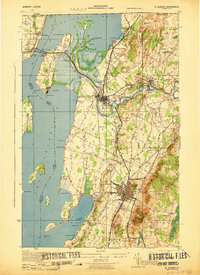
 1943 Plattsburg1943 Print · USGSLake Champlain was a bustling corridor of rail and water traffic in the early 1940s, connecting the Adirondack foothills to the Vermont islands. Genealogists and researchers can trace the old schoolhouses of Beekmantown, the Rutland railroad stops, and historic sites like Hotel Champlain.4 unique versions available
 - 1943 Map of St. Johnsbury
 1943 St. Johnsbury1943 Print · USGSUpper Vermont and New Hampshire communities thrive along the Connecticut and Passumpsic rivers during the early war years. Genealogists can trace family names at Walden Four Corners, find rural schoolhouses like Stanton Sch, or locate the Goslants Mill site.3 unique versions available
 - 1943 Map of Brattleboro
 1943 Brattleboro1943 Print · USGSSouthern Vermont and the Massachusetts border area appear in this mid-century survey as a landscape of timbered peaks and river-connected villages. Genealogists can trace family roots through markers like Arms Cem or follow the rails at Dummerston Sta and Putney Sta.
 - 1943 Map of Cornwall
 1943 Cornwall1943 Print · USGSMid-century Addison County is defined here by the winding waters of Otter Creek and the small agricultural villages of Cornwall and Salisbury. Trace the historic Rutland railroad line and locate local landmarks like Cady School or the Evergreen Cem.7 unique versions available
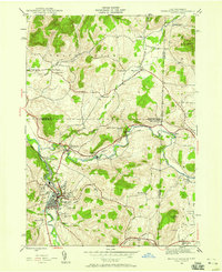
 - 1943 Map of Hyde Park
 1943 Hyde Park1943 Print · USGSLamoille County during the mid-1940s shows a landscape of river-valley industry and upland hill farms. Researchers can locate dozens of country schoolhouses like Wiswell Sch and trace local mining history at the Talc Mine or the Lower Diggings.
 - 1943 Map of Woodstock
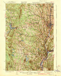
 1943 Woodstock1943 Print · USGSWindsor County's high country and river valleys are captured here during the early 1940s, showing a landscape of small hill farms and rural schools. Researchers can locate many former community hubs like English Mills, the Town Farm, and Notown.
 - 1943 Map of Jay Peak, 1946 Print
 1943 Jay Peak1946 Print · USGSThe Vermont high country comes into focus in the mid-1940s, showing a rugged landscape of rail junctions and mountain industries. Genealogists and historians can locate remote mountain schools like Woodward Sch, the industrial Asbestos Mine, and the mill sites of Hectorville.
 - 1943 Map of Hoosick Falls, 1958 Print
 1943 Hoosick Falls1958 Print · USGSThe New York and Vermont borderlands come alive in this mid-century survey of the Hoosic and Walloomsac valleys. Trace the busy rail junctions of the Boston and Maine and locate historic sites like Bennington Battlefield Park and Sodom.4 unique versions available
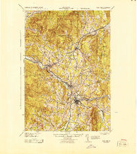
 - 1944 Map of Montpelier
 1944 Montpelier1944 Print · USGSCentral Vermont in the mid-1940s is mapped here with a focus on its mountain settlements and river valley corridors. Genealogists can trace family roots through numerous district schools like Loomis Hill Sch and the location of the Talc Mine.
 - 1944 Map of Milton
 1944 Milton1944 Print · USGSThe Lake Champlain shoreline and the Lamoille River valley are captured here just before the mid-forties. Genealogists and local historians can trace rural schoolhouse districts, the grounds of Fort Ethan Allen, and early lakeside retreats like Camp Winisquam.
 - 1944 Map of Proctor
 1944 Proctor1944 Print · USGSRutland County's industrial and social landscape is captured here in the mid-1940s as rail lines and river valleys define local life. Genealogists and researchers can trace local landmarks like Riverside Cem, Vermont Sanatorium, and the Gorham Bridge crossing.3 unique versions available
 - 1944 Map of Mount Mansfield
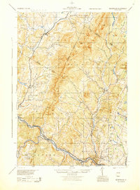
 1944 Mount Mansfield1944 Print · USGSNorthern Vermont in the mid-1940s is defined here by high mountain peaks and a dense network of rural school districts. Genealogists can trace family footprints through numerous local landmarks like Irish Settlement Sch, Marses Mill, and the high-altitude Mt Mansfield Hotel.
 - 1944 Map of Bomoseen
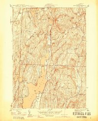 1944 Bomoseen1944 Print · USGSLake Bomoseen and the surrounding hills of Rutland County are captured in the mid-1940s during a period of transition between traditional farming and lakefront recreation. Researchers can locate rural landmarks like Turnpike Sch, East Hubbardton Cem, and the village of West Castleton.5 unique versions available
Showing maps 1-25 of 95
Top cities of Vermont
- Burlington historical maps
- South Burlington historical maps
- Colchester historical maps
- Rutland City historical maps
- Essex historical maps
- Essex Junction historical maps
See more
Top counties of Vermont
- Chittenden County historical maps
- Rutland County historical maps
- Washington County historical maps
- Windsor County historical maps
- Windham County historical maps
- Bennington County historical maps
See more
Frequently asked questions
- What are the different types of historical maps available for Vermont?
- What is the oldest map of Vermont?
- Where can I purchase historical maps of Vermont for my home or office?
- Where can I download high-res historical maps of Vermont?
- Are there historical topographic maps available for Vermont?
- Is there historical aerial imagery available for Vermont?
- Where are historical maps of Vermont sourced from?