1980s Maps of Douglas County, Washington
Explore 18 historic maps of Douglas County from the 1980s. These maps offer a rare glimpse into what life looked like during the 1980s — showing old roads, neighborhoods, homes, and landmarks that have changed or disappeared over time.
Whether you're researching your family's past, planning a metal detecting trip, or studying how Douglas County's landscape evolved across the 1980s, these high-resolution maps are a powerful tool for exploring the history of this region.
- Focus on a specific era: All maps on this page are from the 1980s, giving you a focused view of this time period.
- See what’s changed: Compare century-old streets, trails, and buildings to today's modern landscape using overlays and satellite layers.
- Research with precision: Use these maps for genealogy, historical research, land use analysis, or educational projects.
- View, download, or print: Maps are fully viewable online in high resolution, and can be downloaded or printed for your own records.
Start exploring Douglas County's history through authentic maps from the 1980s. This is your window into the past.
Douglas County, WA maps
(18)- 1980 Map of Bridgeport Point, 1981 Print
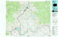
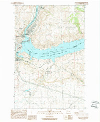
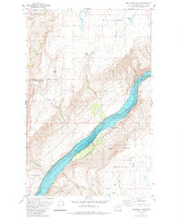 1980 Bridgeport Point1981 Print · USGSThe Columbia River corridor north of Bridgeport comes alive in the early eighties as it flows through the heart of the region. Genealogists and local historians can trace legacy sites like the Bedard School, the shoreline at Brandts Landing, and Pearl Hill.
 - 1980 Map of Bridgeport, 1981 Print
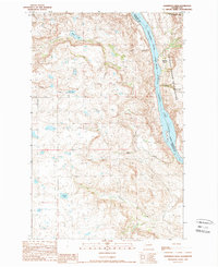
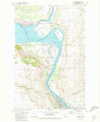 1980 Bridgeport1981 Print · USGSThe Columbia River corridor near Bridgeport reflects a decade of resource management and historical preservation in the early eighties. Researchers can trace the river's bend from Old Port Columbia to Downing, identifying Fort Okanogan State Park and the rugged contours of Castle Rock.
 - 1980 Map of Trefry Canyon, 1981 Print
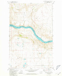
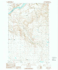
 1980 Trefry Canyon1981 Print · USGSThe Columbia River plateau in the early 1980s reveals a landscape of remote springs and deep canyons north of Del Rio. Genealogists and historians can trace family-named sites like Sellers Eddy, Trefry Springs, and the Delrio Grange Hall.
 - 1981 Map of Stubblefield Point
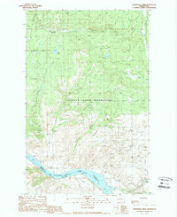
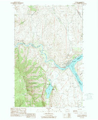
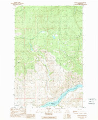
 1981 Stubblefield Point1981 Print · USGSThe Columbia River plateau in Douglas County comes to life in the early 1980s, showing a landscape defined by high-elevation lakes and the canyon of Rufus Woods Lake. Locate the former settlement of Pearl (Site) or trace family landmarks near Nilles Corner and Klinkhammer Lakes.2 unique versions available
 - 1982 Map of Moses Lake, 1983 Print
 1982 Moses Lake1983 Print · USGSThe Columbia Basin during the early eighties shows a landscape transformed by large-scale irrigation and military aviation. Researchers can trace the development of Larson Air Force Base or locate vanished rail stops along the Burlington Northern near Ephrata and Quincy.2 unique versions available
 - 1983 Map of Coulee Dam
 1983 Coulee Dam1983 Print · USGSThe high plateau and deep coulees of central Washington are captured here in the early eighties, centered on the massive Franklin D Roosevelt Lake and the towns of Coulee Dam and Grand Coulee. Researchers can trace the Burlington Northern rail corridor through old stops at Govan and Mondovi or locate the historic Fort Spokane.2 unique versions available
 - 1983 Map of Omak
 1983 Omak1983 Print · USGSIn the early 1980s, the Okanogan and Columbia river valleys served as a vital agricultural and timber hub. Researchers can trace family-named landmarks like Pearl Hill and Jackass Butte, alongside vanished mining history at the Red Shirt Mine.2 unique versions available
 - 1984 Map of Nespelem
 1984 Nespelem1984 Print · USGSThe Colville Indian Reservation and the Columbia River valley are shown here in the mid-1980s, just as modern recreation was shaping the landscape. Genealogists and researchers can locate old communities like Inchelium and Keller or trace mining history at the Germania Mine.
 - 1985 Map of Sagebrush Flat
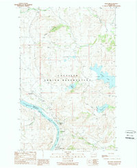
 1985 Sagebrush Flat1985 Print · USGSThe high plateau of the Columbia Basin in the mid-1980s is captured here at the boundary of Douglas and Grant counties. Researchers can trace the rugged geography of Coyote Canyon, the prominence of Mc Cartney, and early water sources like Spring.
 - 1986 Map of Little Soap Lake
 1986 Little Soap Lake1986 Print · USGSThe alkaline lake basins of central Washington are captured here in the 1980s as the town of Soap Lake continued to grow. Researchers can locate distinct geological and cultural sites including Horsethief Cave, Pate Spring, and the Lake Lenore shoreline.
 - 1989 Map of Armstrong Creek
 1989 Armstrong Creek1989 Print · USGSThe northern reaches of the Colville Indian Reservation and the Okanogan highlands are captured here in the late 1980s. Local researchers can trace historic mining activity through several named claims, including the Sailor Boy Mine, Apache Mine, and numerous Mina Shafts.2 unique versions available
 - 1989 Map of Belvedere
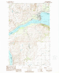
 1989 Belvedere1989 Print · USGSThe northern banks of the Columbia River are shown here in the late 1980s as the river swells into the Rufus Woods Lake reservoir. Genealogists and local historians can trace the riverside communities of Seatons Grove, Koontzville, and Elmer City, as well as the upland waters of Buffalo Lake and McGinnis Lake.2 unique versions available
 - 1989 Map of Brewster
 1989 Brewster1989 Print · USGSThe town of Brewster and the wide reach of the Columbia River are captured here in the late eighties. Researchers can trace the local cemetery and water infrastructure or locate landmarks like Tenas Mtn and the Indian Dan State Wildlife Recreation Area.2 unique versions available
 - 1989 Map of Grand Coulee Dam
 1989 Grand Coulee Dam1989 Print · USGSIn the late 1980s, the Columbia River landscape was defined by the massive scale of the Grand Coulee Dam and its surrounding government settlements. Researchers can trace the layout of Elmer City and Grand Coulee alongside infrastructure like the Pumping Station and Colville Indian Reservation.
 - 1989 Map of Sanderson Creek
 1989 Sanderson Creek1989 Print · USGSThe Douglas County high country and the Colville Indian Reservation meet along the Columbia River in the late eighties. Researchers can trace land boundaries near Buckley Bar or locate remote water features like Black Lake and Schoolhouse Creek.2 unique versions available
 - 1989 Map of Alameda Flat
 1989 Alameda Flat1989 Print · USGSDouglas County high-country meets the Columbia River in the late eighties, showing the transition from the Colville Indian Reservation to plateau ranchlands. Researchers can trace remote rural outposts like Alameda and Osborne Corner alongside landmarks like Balloon Rock.2 unique versions available
 - 1989 Map of Pateros
 1989 Pateros1989 Print · USGSThe confluence of the Methow and Columbia Rivers comes into focus in the late 1980s, showcasing the town of Pateros and its riverside infrastructure. Genealogists and historians can locate the local Cem, trace the Indian Allotment Boundary, or find old Mineshafts near Buckhorn Mountain.2 unique versions available
 - 1989 Map of Hopkins Canyon
 1989 Hopkins Canyon1989 Print · USGSThe Colville Indian Reservation in the late eighties reveals a landscape of high mountains and deep canyons above the Columbia River. Local researchers can locate a solitary Grave and trace old paths through Hopkins Canyon or across Saddle Horse Flat.2 unique versions available
End of results
Showing maps 1-18 of 18
Top cities of Douglas County
- East Wenatchee historical maps
- Bridgeport historical maps
- Waterville historical maps
- Rock Island historical maps
- Mansfield historical maps
Frequently asked questions
- What are the different types of historical maps available for Douglas County?
- What is the oldest map of Douglas County?
- Where can I purchase historical maps of Douglas County for my home or office?
- Where can I download high-res historical maps of Douglas County?
- Are there historical topographic maps available for Douglas County?
- Is there historical aerial imagery available for Douglas County?
- Where are historical maps of Douglas County sourced from?