1960s Maps of Douglas County, Washington
Explore 44 historic maps of Douglas County from the 1960s. These maps offer a rare glimpse into what life looked like during the 1960s — showing old roads, neighborhoods, homes, and landmarks that have changed or disappeared over time.
Whether you're researching your family's past, planning a metal detecting trip, or studying how Douglas County's landscape evolved across the 1960s, these high-resolution maps are a powerful tool for exploring the history of this region.
- Focus on a specific era: All maps on this page are from the 1960s, giving you a focused view of this time period.
- See what’s changed: Compare century-old streets, trails, and buildings to today's modern landscape using overlays and satellite layers.
- Research with precision: Use these maps for genealogy, historical research, land use analysis, or educational projects.
- View, download, or print: Maps are fully viewable online in high resolution, and can be downloaded or printed for your own records.
Start exploring Douglas County's history through authentic maps from the 1960s. This is your window into the past.
Douglas County, WA maps
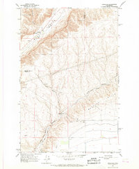
(44)- 1965 Map of Ritzville
 1965 Ritzville1965 Print · USGSCentral Washington during the mid-sixties shows a landscape shaped by massive irrigation projects and the Cold War. Genealogists and historians can trace rail-town life and military presence through Ephrata Air Base, the Telford Station, and local schools.
 - 1965 Map of Jameson Lake SW, 1966 Print
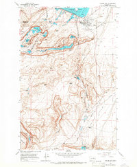
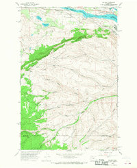
 1965 Jameson Lake SW1966 Print · USGSThe high plateau and deep canyons of Douglas County are captured here in the mid-1960s. Researchers can locate the St Hubert Church and trace the complex drainage of Moses Coulee through landmarks like Sulphur Spring and McCartney Creek.
 - 1965 Map of Jameson Lake SE, 1966 Print
 1965 Jameson Lake SE1966 Print · USGSThe basalt rim of the Lower Grand Coulee and the northern reaches of Lenore Lake define this mid-1960s landscape. Genealogists and local historians can locate the Highland Cemetery, the Highland Sch, and the small settlement of Olin.
 - 1965 Map of St. Andrews, 1966 Print
 1965 St. Andrews1966 Print · USGSThe high plateau of Douglas County is captured here in the mid-1960s, showing a small agricultural community and its vital water sources. Genealogists and historians can locate the St Andrews Cem, the Danish Cem, and landmarks like Gilbert Butte.
 - 1965 Map of Jameson Lake West, 1966 Print
 1965 Jameson Lake West1966 Print · USGSDouglas County agricultural life in the mid-1960s is centered around the dramatic topography of the Moses Coulee and Jameson Lake. Researchers can trace old family landmarks and ranching infrastructure like the Jameson Cem, Dutch Henry Spring, and the western Grain Elevator.
 - 1965 Map of Jameson Lake East, 1966 Print
 1965 Jameson Lake East1966 Print · USGSMoses Coulee and its chain of lakes are captured here in the mid-1960s, showing a landscape of dramatic canyons and high plateaus. Researchers can trace the network of jeep trails connecting Jameson Lake, Grimes Lake, and landmarks like Chester Butte.
 - 1965 Map of Mold, 1967 Print
 1965 Mold1967 Print · USGSMid-century Douglas County is captured here during a period of significant water management and transit shifts. Genealogists and historians can trace the foundations of Mold, locate the Mold Cem, and follow the Old Railroad Grade as it winds toward Fordair.
 - 1965 Map of Park Lake, 1967 Print
 1965 Park Lake1967 Print · USGSThe deep canyon lakes of the Channeled Scablands are captured here in the mid-1960s. Genealogists and researchers can trace the development of Sun Lakes State Park and locate landmarks like McDonald and Big Rock Island.
 - 1965 Map of Coulee City, 1967 Print
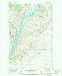
 1965 Coulee City1967 Print · USGSCoulee City sits at the threshold of the spectacular Grand Coulee during the mid-sixties, a period of significant hydroelectric and agricultural development. Genealogists and historians can trace the Northern Pacific rail line through Odair or locate family-named landmarks like McEntee Spring and Arbuckle Draw.3 unique versions available
 - 1966 Map of Palisades, 1967 Print
 1966 Palisades1967 Print · USGSMoses Coulee and the settlement of Palisades are frozen in time during the mid-sixties, when the railway still defined local transit. Researchers can trace the Great Northern rail line as it snakes past Skookumchuck Spring and Douglas Creek.
 - 1966 Map of Malaga NE, 1967 Print
 1966 Malaga NE1967 Print · USGSThe Douglas County highlands come into sharp focus during the mid-1960s, showing a landscape shaped by deep canyons and high plateaus. Researchers can trace remote mountain roads and vital water sources like Luehm Spring, Robinson Spring, and the prominent Moses Stool landform.
 - 1966 Map of Rock Island, 1967 Print
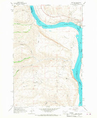
 1966 Rock Island1967 Print · USGSThe Douglas County high country meets the river valley in the mid-1960s, showing a landscape shaped by aviation and agriculture. Researchers can trace the development of Pangborn Field, locate the Hamilton Cem, and follow the Great Northern rail line along the Columbia River.2 unique versions available
 - 1966 Map of Wenatchee, 1968 Print
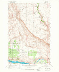
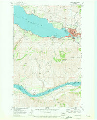
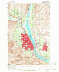 1966 Wenatchee1968 Print · USGSWenatchee and the river valley were flourishing mid-century as major apple-growing and rail hubs. Genealogists and local researchers can locate numerous schools and cemeteries like Sunnyslope Cem, Evergreen Memorial Park, and the Golden King Mine.5 unique versions available
 - 1966 Map of Rattlesnake Springs, 1968 Print
 1966 Rattlesnake Springs1968 Print · USGSMoses Coulee and the Douglas-Grant county line are captured here in the mid-sixties, a period defined by ranching access and geological study. Researchers can trace historic water sources like Rattlesnake Springs and the winding path of the Three Devils Grade.
 - 1966 Map of West Bar, 1968 Print
 1966 West Bar1968 Print · USGSThe Columbia River gorge and the settlement of Trinidad are captured here in the mid-sixties, showing a landscape shaped by the Great Northern rail line. Researchers can trace the development of the Crescent Bar Recreation Area or locate remote landmarks like Sumac Spring and the Tekison Trail.2 unique versions available
 - 1966 Map of Appledale, 1968 Print
 1966 Appledale1968 Print · USGSThe high desert of Central Washington in the mid-1960s shows a landscape defined by dramatic geological features and railroad engineering. Researchers can trace the Great Northern rail line through Moses Coulee and locate historical sites like Chief Moses Council Cave and Appledale.2 unique versions available
 - 1966 Map of Rock Island Dam, 1968 Print
 1966 Rock Island Dam1968 Print · USGSThe mid-1960s landscape along the Columbia River highlights the industrial development of the hydroelectric corridor. Researchers can trace the rail-and-river economy through the Rock Island Dam, the settlement of Voltage, and the Great Northern tracks.
 - 1966 Map of Malaga, 1968 Print
 1966 Malaga1968 Print · USGSSettled along the Columbia River in the mid-sixties, this area shows a transition from riverfront rail hubs to high ridge country. Trace the Great Northern tracks through Malaga or explore the remote Colockum Research Unit Washington State University.2 unique versions available
 - 1968 Map of Withrow, 1971 Print
 1968 Withrow1971 Print · USGSThe community of Withrow and its high-plateau grain country are captured here in the late sixties. Genealogists and local historians can locate the Happy Home Cem, the Grain Elevator by the Burlington Northern tracks, and various Cisterns.
 - 1968 Map of Chelan, 1971 Print
 1968 Chelan1971 Print · USGSThe town of Chelan and the southeastern tip of its namesake lake are documented here in the late sixties as the area transitioned into a regional recreation center. Researchers can find lakeside settlements like Lakeside and Minneapolis Beach, trace the Burlington Northern rail line, or locate the Chelan Fraternal Cem.3 unique versions available
 - 1968 Map of Lamoine, 1971 Print
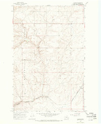 1968 Lamoine1971 Print · USGSThe high wheat country of the Waterville Plateau is captured here in the late sixties, showing a landscape of isolated farmsteads and rail-side industry. Trace the rural infrastructure of Lamoine or locate the Grain Elevator and Fletcher Cem near the southern rail lines.2 unique versions available
 - 1968 Map of Chelan Falls, 1971 Print
 1968 Chelan Falls1971 Print · USGSThe Columbia River corridor south of Chelan shows a landscape of high plateaus and riverfront industry in the late sixties. Trace the old rail lines through Chelan Station or locate family sites at Riverview Cem and the settlement of Beebe.2 unique versions available
 - 1968 Map of Alstown, 1971 Print
 1968 Alstown1971 Print · USGSCentral Washington's wheat country and deep-cut canyons come into focus during the late sixties as the rail-and-grain economy flourished. Trace family history at Douglas Lutheran Cem or follow the Burlington Northern tracks through Alstown.
 - 1968 Map of Chief Joseph Dam, 1971 Print
 1968 Chief Joseph Dam1971 Print · USGSThe Columbia River corridor near the Douglas-Okanogan county line comes into focus in the late sixties, just after the completion of major hydroelectric projects. Local historians can trace the topography of Sourdough Flats and locate family landmarks like Sharyer Spring or McClain Lake alongside the Chief Joseph Dam.
 - 1968 Map of Steamboat Rock SW, 1971 Print
 1968 Steamboat Rock SW1971 Print · USGSThe flooded reaches of the Upper Grand Coulee define this late 1960s landscape after the reservoir's creation. Genealogists and local historians can locate early landmarks like Ferguson, Blain, and the prominent Steamboat Rock overlooking Banks Lake.
Showing maps 1-25 of 44
Top cities of Douglas County
- East Wenatchee historical maps
- Bridgeport historical maps
- Waterville historical maps
- Rock Island historical maps
- Mansfield historical maps
Frequently asked questions
- What are the different types of historical maps available for Douglas County?
- What is the oldest map of Douglas County?
- Where can I purchase historical maps of Douglas County for my home or office?
- Where can I download high-res historical maps of Douglas County?
- Are there historical topographic maps available for Douglas County?
- Is there historical aerial imagery available for Douglas County?
- Where are historical maps of Douglas County sourced from?