1900s (20th Century) Maps of Lewis County, Washington
Explore 159 historic maps of Lewis County from the 1900s (20th Century). These maps offer a rare glimpse into what life looked like during the 1900s — showing old roads, neighborhoods, homes, and landmarks that have changed or disappeared over time.
Whether you're researching your family's past, planning a metal detecting trip, or studying how Lewis County's landscape evolved across the 1900s, these high-resolution maps are a powerful tool for exploring the history of this region.
- Focus on a specific era: All maps on this page are from the 1900s, giving you a focused view of this time period.
- See what’s changed: Compare century-old streets, trails, and buildings to today's modern landscape using overlays and satellite layers.
- Research with precision: Use these maps for genealogy, historical research, land use analysis, or educational projects.
- View, download, or print: Maps are fully viewable online in high resolution, and can be downloaded or printed for your own records.
Start exploring Lewis County's history through authentic maps from the 1900s. This is your window into the past.
Lewis County, WA maps
(159)- 1902 Map of Mount Aix
 1902 Mount Aix1902 Print · USGSThe eastern Cascades around Yakima are captured here at the start of the twentieth century, showing a high-country landscape of early mining and pack trails. Genealogists and historians can locate the site of Fife's Mine, the settlement at Goose Prairie, and early landmarks like Lake House.
 - 1904 Map of Mt Aix
 1904 Mt Aix1904 Print · USGSThe high mountain passes and forest reserves of the Central Cascades are captured here at the start of the century. Genealogists and researchers can trace early outposts like Russell Ranch and the Lake House, or locate the Fires Mine and remote Mc Allister Meadows.6 unique versions available
 - 1904 Map of Mount Adams, 1956 Print
 1904 Mount Adams1956 Print · USGSThe South Cascades and the Yakima Indian Reservation are captured here at the start of the twentieth century, during a time of early timber and ranching growth. Researchers can trace historic mills and stock routes through Glenwood, Hoppers Mill, and Parrotts Bridge.2 unique versions available
 - 1907 Map of Mount Adams
 1907 Mount Adams1907 Print · USGSThe high Cascades and the western reaches of the Yakima Reservation are mapped here in the early twentieth century. Researchers can locate early homesteads and industry like Kesslers Ranch, Lacroux Mill, and Glenwood among the glacial peaks.5 unique versions available
 - 1916 Map of Chehalis
 1916 Chehalis1916 Print · USGSDuring a period of rapid development along the Chehalis and Skookumchuck Rivers, these valleys supported a thriving network of timber camps and rail towns. Genealogists can trace family landmarks like Logan Hill School, the Centralia Seminary, and the Salmon Creek Mill.4 unique versions available
 - 1919 Map of Mount St Helens
 1919 Mount St Helens1919 Print · USGSThe Cascades wilderness of Cowlitz and Skamania counties comes alive in this era of early forest management and mining. Trace the original profiles of Mt St Helens and Spirit Lake, and locate remote landmarks like Polar Star Mine or Basket Ferry.4 unique versions available
 - 1924 Map of Mt Rainier
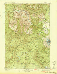
 1924 Mt Rainier1924 Print · USGSLewis and Pierce counties are shown during the mid-twenties, when the timber economy and the National Forest system were establishing their regional footprint. Genealogists and researchers can locate early rural schools like Cline School and Cora School or trace the network of forest outposts like Packwood Ranger Sta.6 unique versions available
 - 1926 Map of Steamboat Mtn, 1954 Print
 1926 Steamboat Mtn1954 Print · USGSThe northern Cascades in the mid-twenties are shown here as a wilderness of timber and ice during the early years of the National Forest system. Researchers can locate remote outposts like Tower Rock Ranger Sta, the historic Williams Mine, and forgotten sites like Graveyard Camp.3 unique versions available
 - 1928 Map of Mt Rainier
 1928 Mt Rainier1928 Print · USGSThe Washington Cascades in the late 1920s reveal a landscape of glaciated peaks and emerging river valley communities. Trace early mountaineering and park history at Longmire, or locate family-named landmarks like Schooley and the Cora School near the Cowlitz River.6 unique versions available
 - 1931 Map of Steamboat Mtn
 1931 Steamboat Mtn1931 Print · USGSSkamania and Lewis Counties appear as a managed wilderness of national forests in the years before World War II. Researchers can trace the early footprint of forest management at the Cispus Lookout Sta and remote sites like Graveyard Camp or Buckhorn Camp.2 unique versions available
 - 1937 Map of Eatonville
 1937 Eatonville1937 Print · USGSThe timber and mining corridors of Pierce and Lewis Counties are captured here in the mid-1930s. Genealogists and historians can trace the early footprints of Eatonville, locate the Ladd Mine, and follow the path of the Chicago Milwaukee St Paul and Pacific RR.3 unique versions available
 - 1940 Map of Tenino
 1940 Tenino1940 Print · USGSThurston County’s rail and timber landscape is documented here at the start of the 1940s, showing a critical intersection of three major railroads. Genealogists and local historians can trace the rural school districts of Spurgeon Creek Sch and the industrial footprint of the Panama Lumber & Shingle Co.
 - 1941 Map of Walville
 1941 Walville1941 Print · USGSThe timber country and rail towns of southwest Washington are captured here just before the Second World War. Researchers can trace family sites at the Habersetzer Farm, locate the Brittian-Chandler CCC Camp, or follow the Northern Pacific RR through Pe Ell.
 - 1941 Map of Meskill
 1941 Meskill1941 Print · USGSLewis County at the start of the Second World War shows a landscape defined by timber camps and river valleys. Genealogists can trace family roots through Claquato Cem or follow the vanished operations of Schafer Bros Logging Camp No 10.2 unique versions available
 - 1941 Map of Olequa
 1941 Olequa1941 Print · USGSSouthwestern Washington on the eve of the Second World War shows a landscape defined by the Cowlitz River and the Northern Pacific rail line. Genealogists can trace early homesteads along Winlock to Toledo Road or locate family roots near St Francis Mission and Silver Lake.
 - 1941 Map of Gate
 1941 Gate1941 Print · USGSThurston and Grays Harbor counties were bustling with rail and timber activity just before the mid-century. Researchers can trace the junction of four railroads near Gate or locate early rural sites like the Michigan Hill Sch and Jewelstock Ranch.
 - 1941 Map of Skamokawa
 1941 Skamokawa1941 Print · USGSWahkiakum County's timber and river culture is captured here during the early 1940s, showing the intersection of logging camps and Columbia River fisheries. Researchers can locate family landmarks like the Oatfield Ranch, trace the Crown Willamette Headquarters Camp, or find the Fern Hill Cemetery.
 - 1941 Map of Tanwax Lake
 1941 Tanwax Lake1941 Print · USGSPierce County was a busy corridor for timber and defense just before the war, as shown in this detailed 1941 survey. Genealogists and historians can locate Camp 1 Logging Camp, the old Lacamas School, and the winding Chicago Milwaukee St Paul and Pacific rail line.
 - 1941 Map of Ford
 1941 Ford1941 Print · USGSGrays Harbor County at the brink of the Second World War shows a river valley shaped by logging and rail transit. Genealogists and historians can trace the early footprints of Malone, Cedarville, and Saginaw along the banks of the Chehalis River.2 unique versions available
 - 1942 Map of Toutle
 1942 Toutle1942 Print · USGSCowlitz County and the river valleys of the Cascades foothills are captured here in the early nineteen-forties. Genealogists and local historians can trace family locations near Toutle, Gilmore Corners, and St Helens, or locate the specific Toutle Lake School.
 - 1943 Map of Willapa
 1943 Willapa1943 Print · USGSPacific County's timber and rail corridor comes to life during the 1940s as industry follows the winding course of the Willapa River. Genealogists and historians can trace family roots through localized landmarks like Riverview Sch, Camp No 1, and the Willapa State Salmon Hatchery.
 - 1944 Map of Tenino
 1944 Tenino1944 Print · USGSThurston County and the Lewis County border are captured in the mid-1940s, highlighting a landscape shaped by coal mining and heavy rail. Genealogists and historians can trace the positions of old schools like Cattail Sch, local landmarks such as the Oregon Trail Monument, and mining sites including Tono Mine No 1.
 - 1944 Map of Yelm
 1944 Yelm1944 Print · USGSThe Nisqually River valley and the surrounding prairies are captured here during the 1940s as military and rail infrastructure reshaped the landscape. Researchers can trace the rail corridors of the Northern Pacific, the Centralia Power Plant, and local landmarks like Collins Sch and Vail.2 unique versions available
 - 1944 Map of Ohop Valley
 1944 Ohop Valley1944 Print · USGSThe Ohop Valley and surrounding Pierce County timberlands are shown here during the mid-1940s, just as the region’s hydroelectric and forestry infrastructure was maturing. Genealogists and researchers can trace rural life through sites like the Grange Hall, Edgerton Sch, and the logging community at Clay City.
 - 1949 Map of Ohop Valley, 1958 Print
 1949 Ohop Valley1958 Print · USGSThe Ohop Valley area in the late 1940s was a hub of timber and rail, where the Milwaukee Road winds through the foothills. Genealogists can locate family landmarks like Truth School Cem, Edgerton School, and the settlement at Clay City.2 unique versions available
Showing maps 1-25 of 159
Top cities of Lewis County
- Centralia historical maps
- Chehalis historical maps
- Napavine historical maps
- Winlock historical maps
- Packwood historical maps
- Morton historical maps
See more
Frequently asked questions
- What are the different types of historical maps available for Lewis County?
- What is the oldest map of Lewis County?
- Where can I purchase historical maps of Lewis County for my home or office?
- Where can I download high-res historical maps of Lewis County?
- Are there historical topographic maps available for Lewis County?
- Is there historical aerial imagery available for Lewis County?
- Where are historical maps of Lewis County sourced from?