2000-2009 Maps of Lewis County, Washington
Explore 4 historic maps of Lewis County from 2000-2009. These maps offer a rare glimpse into what life looked like during the 2000s — showing old roads, neighborhoods, homes, and landmarks that have changed or disappeared over time.
Whether you're researching your family's past, planning a metal detecting trip, or studying how Lewis County's landscape evolved across the 2000s, these high-resolution maps are a powerful tool for exploring the history of this region.
- Focus on a specific era: All maps on this page are from the 2000s, giving you a focused view of this time period.
- See what’s changed: Compare century-old streets, trails, and buildings to today's modern landscape using overlays and satellite layers.
- Research with precision: Use these maps for genealogy, historical research, land use analysis, or educational projects.
- View, download, or print: Maps are fully viewable online in high resolution, and can be downloaded or printed for your own records.
Start exploring Lewis County's history through authentic maps from the 2000s. This is your window into the past.
Lewis County, WA maps
(4)- 2000 Map of Cougar Lake, 2001 Print
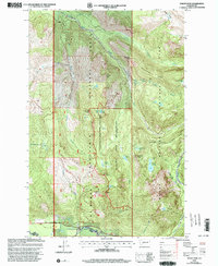
 2000 Cougar Lake2001 Print · USGSThe high Cascade crest at the turn of the millennium serves as a meeting point for major wilderness areas and national forests. Researchers can trace the path of the Pacific Crest National Scenic Trail past the Patrol Cabin and numerous alpine waters like Cougar Lake.
 - 2000 Map of Mount Wow, 2003 Print
 2000 Mount Wow2003 Print · USGSThe high ridges and glacial valleys of Pierce County are captured here at the turn of the millennium, spanning the border of Mount Rainier National Park. Researchers can locate the Marine Memorial Airplane Crash Monument and the Patrol Cabin Shelter.
 - 2000 Map of Bernier Creek, 2003 Print
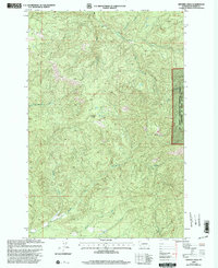 2000 Bernier Creek2003 Print · USGSLewis County's timberlands and river headwaters are captured at the turn of the millennium in this detailed forest survey. Researchers can trace the winding paths of the Skookumchuck River, Windy Knob, and the various forks of the Newaukum River.
 - 2000 Map of Spiral Butte, 2003 Print
 2000 Spiral Butte2003 Print · USGSYakima County’s high alpine wilderness and the White Pass corridor are shown here at the turn of the millennium. Outdoor historians and researchers can trace trails through Blankenship Meadows or locate historic recreation sites like Dog Lake Campground and the landing at Dudley.
End of results
Showing maps 1-4 of 4
Top cities of Lewis County
- Centralia historical maps
- Chehalis historical maps
- Napavine historical maps
- Winlock historical maps
- Packwood historical maps
- Morton historical maps
See more
Frequently asked questions
- What are the different types of historical maps available for Lewis County?
- What is the oldest map of Lewis County?
- Where can I purchase historical maps of Lewis County for my home or office?
- Where can I download high-res historical maps of Lewis County?
- Are there historical topographic maps available for Lewis County?
- Is there historical aerial imagery available for Lewis County?
- Where are historical maps of Lewis County sourced from?