1990s Maps of Forest County, Wisconsin
Explore 6 historic maps of Forest County from the 1990s. These maps offer a rare glimpse into what life looked like during the 1990s — showing old roads, neighborhoods, homes, and landmarks that have changed or disappeared over time.
Whether you're researching your family's past, planning a metal detecting trip, or studying how Forest County's landscape evolved across the 1990s, these high-resolution maps are a powerful tool for exploring the history of this region.
- Focus on a specific era: All maps on this page are from the 1990s, giving you a focused view of this time period.
- See what’s changed: Compare century-old streets, trails, and buildings to today's modern landscape using overlays and satellite layers.
- Research with precision: Use these maps for genealogy, historical research, land use analysis, or educational projects.
- View, download, or print: Maps are fully viewable online in high resolution, and can be downloaded or printed for your own records.
Start exploring Forest County's history through authentic maps from the 1990s. This is your window into the past.
Forest County, WI maps
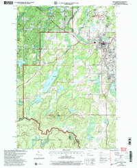
(6)- 1990 Map of Wabeno, 1991 Print
 1990 Wabeno1991 Print · USGSThe Wisconsin Northwoods in the early nineties is a landscape of deep timber, tribal lands, and glacial lakes. Researchers can trace the Chicago and North Western rail line through lumber towns like Wabeno and Townsend or locate the Lakewood State Fish Hatchery.
 - 1990 Map of Merrill, 1991 Print
 1990 Merrill1991 Print · USGSWisconsin's Northwoods transition from timber industry to recreation in the 1990s, centered on the river corridors of Lincoln and Langlade counties. Genealogists and historians can trace rail history along the Soo Line and Old RR Grade between Merrill and Antigo.
 - 1991 Map of Iron Mountain
 1991 Iron Mountain1991 Print · USGSThe Michigan-Wisconsin borderlands appear here in the early nineties, centered on the industrial corridor along the Menominee River. Local researchers can trace the Soo Line through remote timber settlements or locate mining sites like the Bradley Mine and Trader Mine.
 - 1999 Map of Smoky Lake, 2004 Print
 1999 Smoky Lake2004 Print · USGSThe Michigan-Wisconsin borderlands appear here in the late twentieth century as a heavily forested landscape of glacial lakes. Local historians and sportsmen can trace access points to Big Sand Lake, the Phelps Municipal Landing Strip, and secluded waters like Kaine Lake.
 - 1999 Map of Hagerman Lake, 2004 Print
 1999 Hagerman Lake2004 Print · USGSThe Michigan-Wisconsin borderlands near Nelma come alive in this late-twentieth-century study of the Upper Peninsula's forested lake country. Researchers can trace the winding Brule River and identify specific access points and homestead routes near Hagerman Lake and Lake Ottawa.
 - 1999 Map of Iron River, 2004 Print
 1999 Iron River2004 Print · USGSMining settlements near the Michigan-Wisconsin border come into focus in the late 1990s as these timbered lands were re-surveyed. Genealogists can trace the residential layouts of Homer Location and Forbes Location within this Iron County landscape.
End of results
Showing maps 1-6 of 6
Top cities of Forest County
- Crandon historical maps
- Laona historical maps
- Wabeno historical maps
- Nashville historical maps
- Argonne historical maps
- Armstrong Creek historical maps
See more
Frequently asked questions
- What are the different types of historical maps available for Forest County?
- What is the oldest map of Forest County?
- Where can I purchase historical maps of Forest County for my home or office?
- Where can I download high-res historical maps of Forest County?
- Are there historical topographic maps available for Forest County?
- Is there historical aerial imagery available for Forest County?
- Where are historical maps of Forest County sourced from?