1960s Maps of Forest County, Wisconsin
Explore 9 historic maps of Forest County from the 1960s. These maps offer a rare glimpse into what life looked like during the 1960s — showing old roads, neighborhoods, homes, and landmarks that have changed or disappeared over time.
Whether you're researching your family's past, planning a metal detecting trip, or studying how Forest County's landscape evolved across the 1960s, these high-resolution maps are a powerful tool for exploring the history of this region.
- Focus on a specific era: All maps on this page are from the 1960s, giving you a focused view of this time period.
- See what’s changed: Compare century-old streets, trails, and buildings to today's modern landscape using overlays and satellite layers.
- Research with precision: Use these maps for genealogy, historical research, land use analysis, or educational projects.
- View, download, or print: Maps are fully viewable online in high resolution, and can be downloaded or printed for your own records.
Start exploring Forest County's history through authentic maps from the 1960s. This is your window into the past.
Forest County, WI maps
(9)- 1960 Map of Iron River
 1960 Iron River1960 Print · USGSThe Upper Peninsula’s western reaches are shown in the late fifties, featuring the industrial infrastructure of the Copper Country and the vast Ottawa National Forest. Researchers can trace the rail lines of the Milwaukee Road through settlements like Bruce Crossing and the White Pine Mine.
 - 1961 Map of Iron River
 1961 Iron River1961 Print · USGSThe Upper Peninsula and northern Wisconsin are shown here in the early 1960s, a landscape defined by the iron range and vast timberlands. Researchers can trace the legacy of mining and rail transport through Caspian, the Lac Du Flambeau Indian Reservation, and the Milwaukee Road.
 - 1965 Map of Monico NE, 1966 Print
 1965 Monico NE1966 Print · USGSOneida County in the mid-1960s remains a landscape of deep timber and glacial water at the edge of the Nicolet National Forest. Genealogists and historians can trace the rail-reliant community of Atkins and early agricultural sites like the Cranberry Bogs near Three Lakes.2 unique versions available
 - 1965 Map of Nashville, 1966 Print
 1965 Nashville1966 Print · USGSOneida and Forest counties in the mid-sixties show a landscape of timber-country settlements and glacial lakes. Genealogists can trace family names at Nashville Cem or Wolfram Cem, while industrial historians can follow the Old Railroad Grade.2 unique versions available
 - 1965 Map of Crandon, 1966 Print
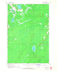
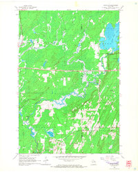
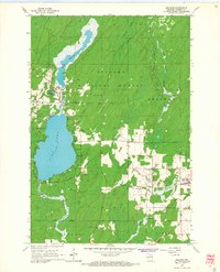
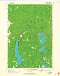
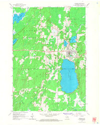 1965 Crandon1966 Print · USGSForest County in the mid-sixties reveals a landscape defined by timber history and sprawling glacial lakes. Researchers can trace the legacy of the logging era through an Old Railroad Grade and locate family landmarks like Lakeside Cemetery or the rural junction at Sherman Corners.2 unique versions available
 - 1965 Map of Argonne, 1966 Print
 1965 Argonne1966 Print · USGSForest County's timber and rail history is on full display here in the mid-sixties, centered on the communities of Argonne and Hiles. Genealogists and historians can locate St Marys Cem, the old Soo Line rail corridors, and the Hiles Lookout Tower overlooking the Nicolet National Forest.2 unique versions available
 - 1965 Map of Lake Lucerne, 1967 Print
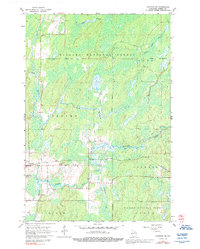
 1965 Lake Lucerne1967 Print · USGSForest County's dense northern woodlands are captured here during the mid-sixties, showing the rugged lake-and-hill country of the Nicolet National Forest. You can locate landmarks like the Lookout Tower on Sugarbush Hill and the remote Boy Scout Camp on the shores of Hardwood Lake.2 unique versions available
 - 1965 Map of Crandon NE, 1992 Print
 1965 Crandon NE1992 Print · USGSForest County in the mid-1960s was a landscape where the Northwoods timber industry met the rails. Trace the path of the Soo Line as it connects the settlements of Argonne and Middle, or follow the winding courses of the Peshtigo River and Popple River.
 - 1967 Map of Iron River, 1968 Print
 1967 Iron River1968 Print · USGSThe Upper Peninsula and northern Wisconsin borderlands are shown here in the late sixties, a landscape of deep woods and iron-country rail lines. Genealogists and historians can trace the lakeside settlements of L'Anse and Ontonagon or follow the Soo Line through towns like Michigamme and Nestoria.
End of results
Showing maps 1-9 of 9
Top cities of Forest County
- Crandon historical maps
- Laona historical maps
- Wabeno historical maps
- Nashville historical maps
- Argonne historical maps
- Armstrong Creek historical maps
See more
Frequently asked questions
- What are the different types of historical maps available for Forest County?
- What is the oldest map of Forest County?
- Where can I purchase historical maps of Forest County for my home or office?
- Where can I download high-res historical maps of Forest County?
- Are there historical topographic maps available for Forest County?
- Is there historical aerial imagery available for Forest County?
- Where are historical maps of Forest County sourced from?