1970s Maps of Forest County, Wisconsin
Explore 20 historic maps of Forest County from the 1970s. These maps offer a rare glimpse into what life looked like during the 1970s — showing old roads, neighborhoods, homes, and landmarks that have changed or disappeared over time.
Whether you're researching your family's past, planning a metal detecting trip, or studying how Forest County's landscape evolved across the 1970s, these high-resolution maps are a powerful tool for exploring the history of this region.
- Focus on a specific era: All maps on this page are from the 1970s, giving you a focused view of this time period.
- See what’s changed: Compare century-old streets, trails, and buildings to today's modern landscape using overlays and satellite layers.
- Research with precision: Use these maps for genealogy, historical research, land use analysis, or educational projects.
- View, download, or print: Maps are fully viewable online in high resolution, and can be downloaded or printed for your own records.
Start exploring Forest County's history through authentic maps from the 1970s. This is your window into the past.
Forest County, WI maps
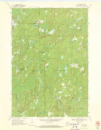
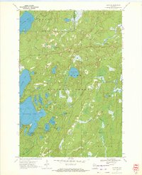
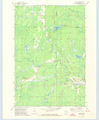
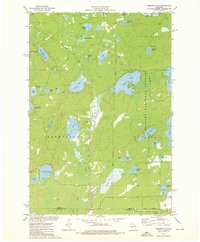
(20)- 1970 Map of Tipler, 1972 Print
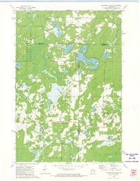
 1970 Tipler1972 Print · USGSForest County's timber and lake country is captured here in the early seventies as the rail-and-water economy shaped the landscape. Genealogists and historians can trace the Chicago and North Western line or locate the Martin Cem and Maple Grove Ch.2 unique versions available
 - 1970 Map of Alvin, 1972 Print
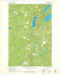
 1970 Alvin1972 Print · USGSForest County in the early seventies shows a remote logging and recreation landscape centered on the settlement of Alvin. Researchers can trace old family landmarks and local infrastructure like Lakeview Cem, the Pine River Lookout Tower, and Windsor Dam Campground.3 unique versions available
 - 1970 Map of Long Lake, 1972 Print
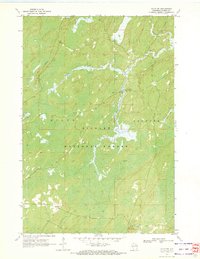
 1970 Long Lake1972 Print · USGSFlorence and Forest Counties are shown in the early seventies, centered on the logging and rail lands of the Nicolet National Forest. You can locate historical landmarks like the Long Lake Lookout Tower, the Townhall, and the Long Lake Cemetery.2 unique versions available
 - 1970 Map of Alvin SW, 1972 Print
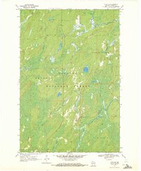
 1970 Alvin SW1972 Print · USGSForest County, Wisconsin, is captured here in the early 1970s within the vast boundaries of the Nicolet National Forest. You can trace old logging routes along the Railroad Grade or locate fishing spots near the Pine River Campground and Peshtigo River.2 unique versions available
 - 1970 Map of Alvin SE, 1972 Print
 1970 Alvin SE1972 Print · USGSForest County, Wisconsin, is depicted here in the early seventies as a dense patchwork of federal timberlands and glacial waterways. Researchers can trace the winding paths of the Pine River and Popple River or locate remote landmarks like Rat Lake.3 unique versions available
 - 1970 Map of Alvin NW, 1972 Print
 1970 Alvin NW1972 Print · USGSForest County's wilderness is documented here in the early 1970s, showcasing a landscape defined by the Nicolet National Forest. You can trace old shoreline features and forest access points near Butternut Lake, Franklin Lake, and the Luna-White Deer Campground.2 unique versions available
 - 1970 Map of Julia Lake, 1972 Print
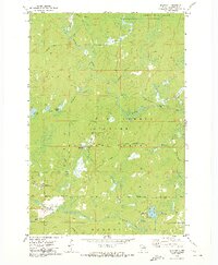
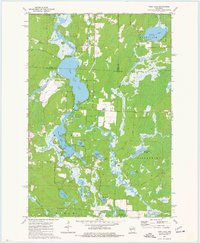
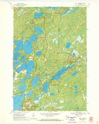 1970 Julia Lake1972 Print · USGSOneida County's interconnected lake chains are captured here in the early seventies as the area grew into a recreational hub. Researchers can trace historic routes like Military Road and locate local landmarks such as Three Lakes Municipal Airport and Big Stone Lake.2 unique versions available
 - 1970 Map of Anvil Lake, 1972 Print
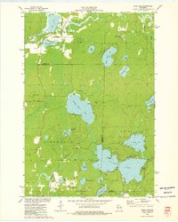
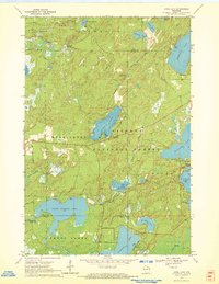 1970 Anvil Lake1972 Print · USGSThe Nicolet National Forest at the start of the 1970s reveals a pristine landscape of glacial lakes and timber. Trace early recreation sites and forest infrastructure like the Anvil Lake Lookout Tower and Military Road.2 unique versions available
 - 1972 Map of Lake Gordon, 1974 Print
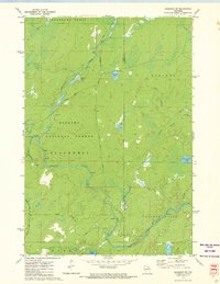
 1972 Lake Gordon1974 Print · USGSThe Northwoods of Forest and Florence Counties are captured here in the early 1970s within the sprawling Nicolet National Forest. Trace the path of the Soo Line railroad past Bonneval or locate the Newald Lookout Tower and Wayside Park.2 unique versions available
 - 1972 Map of Newald, 1974 Print
 1972 Newald1974 Print · USGSForest and Florence counties meet in this 1970s survey of northern Wisconsin’s timber country. Genealogists and local historians can trace the rail corridors of the Chicago and North Western and Soo Line, identifying old sites at Newald, Cavour, and the Consolidated Lookout Tower.2 unique versions available
 - 1972 Map of Laona, 1974 Print
 1972 Laona1974 Print · USGSLaona and the surrounding timberlands in the early seventies reveal a landscape deeply integrated with the Nicolet National Forest. Genealogists and historians can trace the rail-driven economy via the Chicago and North Western line and locate sites like Starks Settlement and the Laona Cem.
 - 1972 Map of Blackwell, 1974 Print
 1972 Blackwell1974 Print · USGSForest County during the 1970s reveals a landscape of dense woods and winding waterways managed under the Nicolet National Forest. You can trace the community at Blackwell, find the local Cem, and follow the Old Railroad Grade along the Rat River.
 - 1972 Map of Goodman SW, 1974 Print
 1972 Goodman SW1974 Print · USGSForest and Marinette counties during the early seventies reveal a landscape of timber and trout streams deep within the Nicolet National Forest. Outdoor enthusiasts and historians can trace the course of the Peshtigo River past the Burnt Bridge Campground and remote rapids.2 unique versions available
 - 1972 Map of Armstrong Creek, 1974 Print
 1972 Armstrong Creek1974 Print · USGSThe northern woods of Forest and Marinette counties appear in the early seventies, dominated by the Nicolet National Forest. Genealogists and historians can trace the Soo Line and Old Railroad Grade near Armstrong Creek or locate Pine Hill Cem and Hillside Cem.2 unique versions available
 - 1972 Map of Mc Caslin Mountain, 1975 Print
 1972 Mc Caslin Mountain1975 Print · USGSThe borderlands of Forest and Marinette County in the early seventies reveal a landscape of managed timber and remote glacial lakes. You can trace the Rat River rapids, locate the McCaslin Lookout Tower, and find small landmarks like the Cem or the Deer Lake Flowage.2 unique versions available
 - 1972 Map of Wabeno, 1975 Print
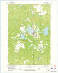
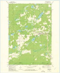 1972 Wabeno1975 Print · USGSForest County in the early 1970s is characterized by the timber-belt communities of Wabeno and Soperton within the Nicolet National Forest. Genealogists and historians can trace rail-side developments, numerous lakefronts, and several local cemeteries like St Ambrose Cem and Roseland Cem.
 - 1972 Map of Otter Lake, 1975 Print
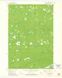
 1972 Otter Lake1975 Print · USGSThe deep Northwoods of Forest County are captured in the early seventies, dominated by the sprawling Nicolet National Forest. Researchers can trace old timber access routes like Kufner Road and locate remote water features such as Johnson Spring and Otter Lake.
 - 1973 Map of Roberts Lake, 1976 Print
 1973 Roberts Lake1976 Print · USGSNorthern Forest County in the early seventies reveals a landscape defined by glacial lakes and the timber-hauling lines of the Soo Line. Genealogists and historians can trace small crossroads like Woodlawn and Freedom Corners tucked between Roberts Lake and the Bog Brook State Wildlife Area.2 unique versions available
 - 1973 Map of Mole Lake, 1976 Print
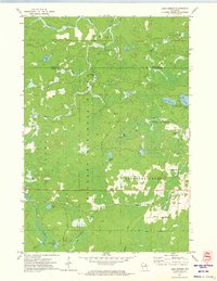
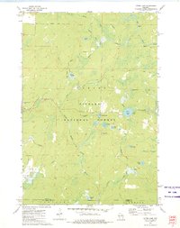
 1973 Mole Lake1976 Print · USGSThe Mole Lake region of northern Wisconsin is shown in the 1970s as a landscape of glacial lakes and reservation lands. Researchers can trace the Soo Line rail corridor or locate landmarks like the Lookout Tower and Kingdom Hall.
 - 1973 Map of Post Lake, 1977 Print
 1973 Post Lake1977 Print · USGSThe Wolf River corridor in the early 1970s reveals a landscape of interconnected lakes and protected fishery lands. Researchers can trace lakeside developments near Post Lake and locate specific features like Knoke Spring, Spider Creek Flowage, and the Wolf River State Fishery Area.2 unique versions available
End of results
Showing maps 1-20 of 20
Top cities of Forest County
- Crandon historical maps
- Laona historical maps
- Wabeno historical maps
- Nashville historical maps
- Argonne historical maps
- Armstrong Creek historical maps
See more
Frequently asked questions
- What are the different types of historical maps available for Forest County?
- What is the oldest map of Forest County?
- Where can I purchase historical maps of Forest County for my home or office?
- Where can I download high-res historical maps of Forest County?
- Are there historical topographic maps available for Forest County?
- Is there historical aerial imagery available for Forest County?
- Where are historical maps of Forest County sourced from?