2000s (21st Century) Maps of Worcester, Wisconsin
Explore 11 historic maps of Worcester from the 2000s (21st Century). These maps offer a rare glimpse into what life looked like during the 2000s — showing old roads, neighborhoods, homes, and landmarks that have changed or disappeared over time.
Whether you're researching your family's past, planning a metal detecting trip, or studying how Worcester's landscape evolved across the 2000s, these high-resolution maps are a powerful tool for exploring the history of this region.
- Focus on a specific era: All maps on this page are from the 2000s, giving you a focused view of this time period.
- See what’s changed: Compare century-old streets, trails, and buildings to today's modern landscape using overlays and satellite layers.
- Research with precision: Use these maps for genealogy, historical research, land use analysis, or educational projects.
- View, download, or print: Maps are fully viewable online in high resolution, and can be downloaded or printed for your own records.
Start exploring Worcester's history through authentic maps from the 2000s. This is your window into the past.
Worcester, WI maps
(11)- 2005 Map of Dover, 2006 Print
 2005 Dover2006 Print · USGSPrice County timberlands and river valleys are shown in detail during the early 2000s as the local road network expanded. Genealogists and local historians can locate the Emery Cem, the Dover Townhall, and small settlements like Uher.
 - 2005 Map of Pike Lake SW, 2006 Print
 2005 Pike Lake SW2006 Print · USGSPrice County’s northern woods and wetlands come alive in the mid-2000s, centered on the protected waters of the Chequamegon-Nicolet. Trace the boundaries of the Wilson Flowage Wildlife Management Area or explore the remote banks of Riley Lake and the Elk River.
 - 2005 Map of Gates Lake, 2006 Print
 2005 Gates Lake2006 Print · USGSPrice County’s forested wetlands and lake systems are captured in detail during the early 2000s. Researchers can locate specific conservation boundaries and recreational sites like Hicks Landing, Sailor Lake, and the Cranberry Bog.
 - 2022 Map of Cranberry Lake, 2022 Print
 2022 Cranberry Lake2022 Print · USGSPrice County in the early 2000s remains a landscape defined by its glacial waters and timberland. Researchers can trace the drainage of the Elk River and Little Elk River or locate family properties near Big Dardis Lake and the Cranberry Lake settlement.
 - 2022 Map of Pike Lake SW, 2022 Print
 2022 Pike Lake SW2022 Print · USGSPrice County’s north woods are shown in detail as they appear today, dominated by the timber and wetlands of the national forest. Researchers can trace recreational corridors like the Price Co Snowmobile 120 Trl and local landmarks such as Wilson Flowage and the Elk River.
 - 2022 Map of Prentice, 2022 Print
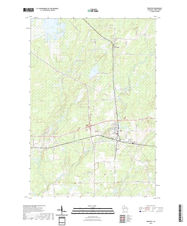 2022 Prentice2022 Print · USGSIn the Northwoods of Price County, this modern survey shows the village of Prentice and the nearby settlement of Worcester. Researchers can trace local lineage through the Hackett Cem or explore the waterways of the South Fork Jump River and Prentice Flowage 59.
 - 2022 Map of Pennington, 2022 Print
 2022 Pennington2022 Print · USGSPrice County settlement and wetland management are documented here in the early twenty-first century. Genealogists and local historians can trace property access near Pennington and along family-named routes like Moonshine Aly and Wears Rd.
 - 2022 Map of Dover, 2022 Print
 2022 Dover2022 Print · USGSPrice County timberlands and the Chequamegon National Forest define this northern Wisconsin landscape in the early 2020s. Genealogists and researchers can locate Dover and the Emery Cem along the winding banks of the Little Elk River.
 - 2023 Map of Phillips, 2023 Print
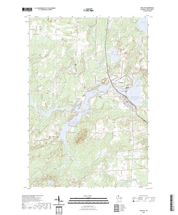 2023 Phillips2023 Print · USGSThe Northwoods city of Phillips and its surrounding lake country are documented here in the early twenty-first century. Researchers can trace local lineage at Saint Patrick Cem or Two Lakes Cem and locate landmarks like the Price County Courthouse.
 - 2023 Map of Priest Lake, 2023 Print
 2023 Priest Lake2023 Print · USGSPrice County’s Northwoods terrain is meticulously detailed here in the early twenty-first century, showing the winding river systems and hidden lakes of northern Wisconsin. Trace the South Fork Flambeau River through Rocky Carry Rapids or locate remote camps near Sailor Creek Flowage and Priest Lake.
 - 2023 Map of Gates Lake, 2023 Print
 2023 Gates Lake2023 Print · USGSPrice County’s dense timberlands and glacial lakes are captured in this recent survey of the Northwoods. Outdoor enthusiasts and local historians can trace the network of the Flambeau Atv 121 Trl and recreation sites around Solberg Lake and Sailor Lake.
End of results
Showing maps 1-11 of 11
Top cities near Worcester
- Park Falls historical maps
- Worcester historical maps
- Phillips historical maps
- Fifield historical maps
- Ogema historical maps
- Prentice historical maps
See more
Top neighborhoods of Worcester
Frequently asked questions
- What are the different types of historical maps available for Worcester?
- What is the oldest map of Worcester?
- Where can I purchase historical maps of Worcester for my home or office?
- Where can I download high-res historical maps of Worcester?
- Are there historical topographic maps available for Worcester?
- Is there historical aerial imagery available for Worcester?
- Where are historical maps of Worcester sourced from?