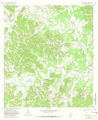
1964 Map of A Bar A Ranch
USGS Topo · Published 1982About this map
The confluence of the North Prong Medina River and the West Prong Medina River defines the landscape of this Bandera County ranching country. During the mid-1960s, this area was characterized by a distinct network of private ranch estates and family burial grounds scattered throughout the creek-fed valleys. Named holdings such as the A Bar A Ranch, Anchor T Ranch, and Circle B Sky Ranch indicate a legacy of large-scale land ownership and private aviation, evidenced by several landing strips located near the ranch houses. Genealogists can find numerous small family plots including the Means Cem, Goodman Cem, and Bauerlein Cem. The rugged topography is etched with seasonal drainages like Mackle Creek and Hough Creek, while more utilitarian features like a Pipeline and isolated gravel pits mark the subtle industrial footprint of the era.
Find a feature on this map
38 named features on this map. Tap any name to fly to it.
Don’t see what you’re looking for? This feature index may not catch every label — zoom into the map to look around manually.
Map Details
Editions of this 1964 A Bar A Ranch Map
2 editions found
Other maps of this area

1954 · San Antonio
USGS Topo · 1:250,000

1956 · Tarpley
USGS Topo · 1:62,500

1956 · Tuff
USGS Topo · 1:62,500

1956 · Bandera
USGS Topo · 1:62,500

1956 · Center Point
USGS Topo · 1:62,500

1957 · San Antonio
USGS Topo · 1:250,000

1964 · Diamond S Ranch
USGS Topo · 1:24,000

1964 · Echo Hill Ranch
USGS Topo · 1:24,000
1964 · Love Creek
USGS Topo · 1:24,000

1964 · Rock Cliff Reservoir
USGS Topo · 1:24,000