
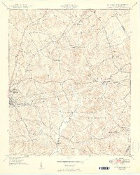
1950 Map of Abbeville East
USGS Topo · Published 1950About this map
Abbeville and its eastern environs are captured here in the mid-century, where the edge of town gives way to the wooded reaches of the Sumter National Forest. The landscape is a network of small family-named landmarks and rural institutions, including the County Training Sch and several schools like Long Cane Sch and Pine Burr Sch. Industry and infrastructure are defined by the Seaboard Air Line railroad cutting across the southern half of the quadrangle and the presence of Millers Mill on the waters of Long Cane Creek. To the west, the Abbeville Pumping Station and Davis Airport signal the community's growing mid-century utilities. Numerous local churches such as Jones Chapel, Mt Olive Ch, and Allen Chapel anchor the rural settlements, while family burial grounds like Aiken Cem and Big Adams Cem provide valuable touchpoints for genealogists tracing the area's residents.
Find a feature on this map
49 named features on this map. Tap any name to fly to it.
Don’t see what you’re looking for? This feature index may not catch every label — zoom into the map to look around manually.
Map Details
Editions of this 1950 Abbeville East Map
2 editions found
Other maps of this area

1892 · Abbeville
USGS Topo · 1:125,000

1948 · Abbeville East
USGS Topo · 1:24,000

1948 · Verdery
USGS Topo · 1:24,000

1948 · Abbeville West
USGS Topo · 1:24,000

1949 · Abbeville
USGS Topo · 1:24,000

1949 · Calhoun Creek
USGS Topo · 1:24,000

1949 · Greenwood
USGS Topo · 1:24,000

1950 · Bradley
USGS Topo · 1:24,000

1950 · Verdery
USGS Topo · 1:24,000

1954 · Greenville
USGS Topo · 1:250,000