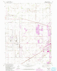
1962 Map of Abbott
USGS Topo · Published 1993About this map
The Corn Husker Ordnance Plant dominates the western landscape of this Hall County survey, illustrating the significant industrial and military footprint in the Nebraska interior during the mid-20th century. Adjacent to this facility, the Cornhusker State Wildlife Management Area provides a stark contrast in land use, while small agricultural hubs like Abbott and Ovina remain linked by the Burlington Northern railroad. The eastern portion of the map transitions into the suburban and industrial fringes of Grand Island, featuring several community facilities including the Drive-in Theater, Westlawn Memorial Cem, and the extensive Grand Island Cemetery. Waterways such as Prairie Creek and Silver Creek meander across the plains, defining the topography of townships like Mayfield and Center. Local education is documented through the locations of rural schoolhouses such as School No 54 and School No 18.
Find a feature on this map
25 named features on this map. Tap any name to fly to it.
Don’t see what you’re looking for? This feature index may not catch every label — zoom into the map to look around manually.
Map Details
Editions of this 1962 Abbott Map
4 editions found
Other maps of this area

1892 · Grand Island
USGS Topo · 1:62,500

1895 · Grand Island
USGS Topo · 1:62,500

1895 · Wood River
USGS Topo · 1:62,500

1896 · Wood River
USGS Topo · 1:125,000

1898 · Grand Island
USGS Topo · 1:125,000

1899 · Loup
USGS Topo · 1:125,000

1899 · St. Paul
USGS Topo · 1:125,000

1953 · Dannebrog
USGS Topo · 1:24,000

1955 · Broken Bow
USGS Topo · 1:250,000

1955 · Grand Island
USGS Topo · 1:250,000