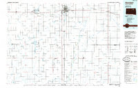
1985 Map of Aberdeen
USGS Topo · Published 1985About this map
Aberdeen serves as the focal point of this mid-1980s landscape, where the confluence of the Burlington Northern and Chicago and North Western rail lines illustrates the city's historic role as a regional transportation hub. Higher education is anchored by Northern State Teachers College and Presentation Heights College, while the Aberdeen Regional Airport marks the shift toward modern transit. Beyond the city limits, the terrain is defined by a dense network of conservation and recreation areas, including the Mina State Recreation Area surrounding Mina Lake and numerous tracts of State Game Production Area. The meandering course of the James River and its tributaries like Moccasin Creek and Mud Creek dominate the eastern half of the sheet, weaving through agricultural townships and small settlements such as Bath and Stratford. An Old Railroad Grade north of Chelsea offers a specific artifact for those tracing vanished infrastructure.
Find a feature on this map
65 named features on this map. Tap any name to fly to it.
Don’t see what you’re looking for? This feature index may not catch every label — zoom into the map to look around manually.
Map Details
Editions of this 1985 Aberdeen Map
2 editions found
Other maps of this area

1894 · Conde
USGS Topo · 1:62,500

1894 · Columbia
USGS Topo · 1:62,500

1895 · Byron
USGS Topo · 1:125,000

1895 · Aberdeen
USGS Topo · 1:125,000

1896 · Columbia
USGS Topo · 1:125,000

1899 · Ellendale
USGS Topo · 1:125,000

1899 · Northville
USGS Topo · 1:125,000

1899 · Redfield
USGS Topo · 1:125,000

1951 · Orient
USGS Topo · 1:24,000

1952 · Wecota
USGS Topo · 1:24,000