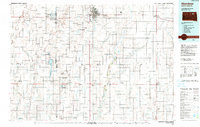
1985 Map of Aberdeen
USGS Topo · Published 1990About this map
Aberdeen serves as the regional anchor for this late-twentieth-century landscape, characterized by the precise grid of the northern Great Plains. The map details the transition of the region’s educational and transportation infrastructure, highlighting Northern State College and Presentation College within the city limits, as well as the Aberdeen Regional Airport to the east. Beyond the city, the land is a complex network of agriculture and conservation, featuring numerous State Game Production Areas and National Waterfowl Production Areas that pepper the townships of Pioneer and New Hope.
Find a feature on this map
92 named features on this map. Tap any name to fly to it.
Don’t see what you’re looking for? This feature index may not catch every label — zoom into the map to look around manually.
Map Details
Editions of this 1985 Aberdeen Map
2 editions found
Other maps of this area

1894 · Conde
USGS Topo · 1:62,500

1894 · Columbia
USGS Topo · 1:62,500

1895 · Byron
USGS Topo · 1:125,000

1895 · Aberdeen
USGS Topo · 1:125,000

1896 · Columbia
USGS Topo · 1:125,000

1899 · Ellendale
USGS Topo · 1:125,000

1899 · Northville
USGS Topo · 1:125,000

1899 · Redfield
USGS Topo · 1:125,000

1951 · Orient
USGS Topo · 1:24,000

1952 · Wecota
USGS Topo · 1:24,000