1960 Map of Aberdeen West
USGS Topo · Published 1975About this map
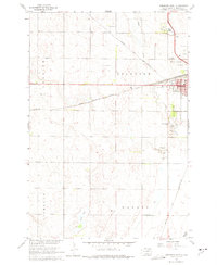
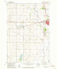
Aberdeen's western expansion and agricultural periphery are documented in this 1960 survey, a time when the prairie landscape was defined by an orderly grid of section lines and township boundaries like T. 123 N. T. 122 N. and R. 65 W. R. 64 W.. The intersection of transport and recreation is evident near Wylie Park and Wylie Lake, while the city's intellectual and spiritual infrastructure is marked by Lincoln Sch and the Riverside Cemetery along Melgaard Road.
Find a feature on this map
28 named features on this map. Tap any name to fly to it.
Don’t see what you’re looking for? This feature index may not catch every label — zoom into the map to look around manually.
Map Details
Editions of this 1960 Aberdeen West Map

Other maps of this area

1894 · Columbia
USGS Topo · 1:62,500

1895 · Aberdeen
USGS Topo · 1:125,000

1896 · Columbia
USGS Topo · 1:125,000

1899 · Ellendale
USGS Topo · 1:125,000

1899 · Northville
USGS Topo · 1:125,000

1952 · Ordway
USGS Topo · 1:24,000
1953 · Warner
USGS Topo · 1:24,000

1954 · Aberdeen
USGS Topo · 1:250,000

1956 · Aberdeen
USGS Topo · 1:250,000
1960 · Aberdeen East
USGS Topo · 1:24,000
Featured Places
- Aberdeen, Aberdeen Township
- Aberdeen Township, SD
- Warner Township, SD
- Mercier Township, SD
- Derian Subdivision, Aberdeen Township