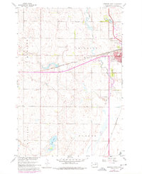
1960 Map of Aberdeen West
USGS Topo · Published 1978About this map
Aberdeen serves as a major rail hub in this mid-century survey, where the Chicago Milwaukee St Paul and Pacific and the Chicago and North Western railroads intersect. The city's western expansion is marked by civic and recreational landmarks, including Lincoln Sch, the Aberdeen Country Club, and the large Riverside Cemetery bordering Moccasin Creek. To the north, the landscape is defined by Wylie Park and Wylie Lake, while the rural areas to the west in Mercier and south in Warner remain predominantly agricultural, interrupted only by water bodies like Lords Lake. This survey includes 1975 photorevised updates shown in purple, documenting the introduction of a Drive-in Theater and communication infrastructure such as the Tower (KXAB-TV) that emerged as the city grew into the modern era.
Find a feature on this map
22 named features on this map. Tap any name to fly to it.
Don’t see what you’re looking for? This feature index may not catch every label — zoom into the map to look around manually.
Map Details
Editions of this 1960 Aberdeen West Map

Other maps of this area

1894 · Columbia
USGS Topo · 1:62,500

1895 · Aberdeen
USGS Topo · 1:125,000

1896 · Columbia
USGS Topo · 1:125,000

1899 · Ellendale
USGS Topo · 1:125,000

1899 · Northville
USGS Topo · 1:125,000

1952 · Ordway
USGS Topo · 1:24,000

1953 · Warner
USGS Topo · 1:24,000

1954 · Aberdeen
USGS Topo · 1:250,000

1956 · Aberdeen
USGS Topo · 1:250,000
1960 · Aberdeen East
USGS Topo · 1:24,000