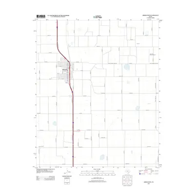
2012 Map of Abernathy
USGS Topo · Published 2012About this map
Abernathy serves as the central hub of this 2012 survey, situated along the Interstate 27 corridor in Hale County. The town is defined by a dense grid of residential and commercial streets, including Texas Ave and numbered thoroughfares from 1st St to 16th St. Beyond the town limits, the landscape transitions into a vast agricultural and industrial network, characterized by a precision grid of county roads such as Co Rd-315 and Co Rd-325. The economic activity of the region is evident through specialized sites like the Cravens Oil Field to the southwest and the Abernathy Municipal Airport to the northeast. Local history is anchored by markers like the Strip Cem, while the modern transport infrastructure is highlighted by Farm-To-Market Road 2060 and the I 27 Service Rd, which facilitate movement through this High Plains community.
Find a feature on this map
73 named features on this map. Tap any name to fly to it.
Don’t see what you’re looking for? This feature index may not catch every label — zoom into the map to look around manually.
Map Details
Editions of this 2012 Abernathy Map
This is the sole edition of this map. No revisions or reprints were ever made.
Other maps of this area

1954 · Lubbock
USGS Topo · 1:250,000

1956 · Shallowater
USGS Topo · 1:24,000

1956 · New Deal
USGS Topo · 1:24,000

1957 · Lubbock
USGS Topo · 1:62,500

1957 · Abernathy
USGS Topo · 1:62,500

1965 · Idalou
USGS Topo · 1:24,000

1965 · Heckville
USGS Topo · 1:24,000

1968 · Julia Lake
USGS Topo · 1:24,000
1976 · Abernathy SE
USGS Topo · 1:24,000

1976 · Abernathy NW
USGS Topo · 1:24,000