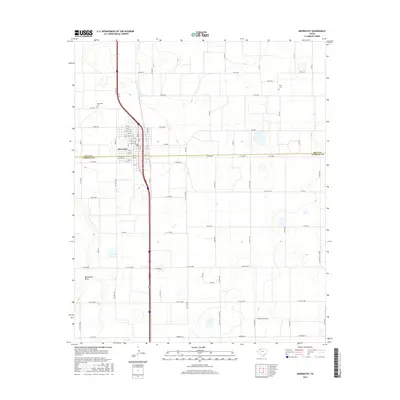
2016 Map of Abernathy
USGS Topo · Published 2016About this map
Abernathy straddles the county line in this high plains landscape, defined by a rigid grid of agricultural roads and the passage of the Interstate 27 corridor. The town layout is clearly delineated by its numbered streets, ranging from 1st St up to 16th St, serving as a central hub for the surrounding ranching and farming operations. To the northwest lies the Abernathy Cem, while the smaller Strip Cem is situated further east, providing vital points of interest for genealogists tracking local families in this portion of the Texas Panhandle.
Find a feature on this map
44 named features on this map. Tap any name to fly to it.
Don’t see what you’re looking for? This feature index may not catch every label — zoom into the map to look around manually.
Map Details
Editions of this 2016 Abernathy Map
This is the sole edition of this map. No revisions or reprints were ever made.
Other maps of this area

1954 · Lubbock
USGS Topo · 1:250,000

1956 · Shallowater
USGS Topo · 1:24,000

1956 · New Deal
USGS Topo · 1:24,000

1957 · Lubbock
USGS Topo · 1:62,500

1957 · Abernathy
USGS Topo · 1:62,500

1965 · Idalou
USGS Topo · 1:24,000

1965 · Heckville
USGS Topo · 1:24,000

1968 · Julia Lake
USGS Topo · 1:24,000
1976 · Abernathy SE
USGS Topo · 1:24,000
1976 · Abernathy NW
USGS Topo · 1:24,000