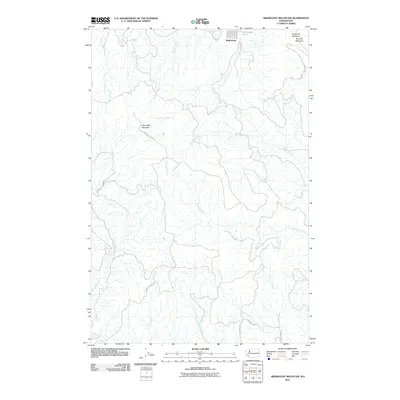
2011 Map of Abernathy Mountain
USGS Topo · Published 2011About this map
Ryderwood anchors the northern edge of this Cowlitz County landscape, where the town's grid of streets including Taylor St and Madison St meets the waters of Ryderwood Pond. The terrain is defined by significant elevations such as Abernathy Mountain, Pumphrey Mountain, and Pumpkin Mountain, which overlook a complex drainage network. Watercourses like Germany Creek, Monahan Creek, and Delameter Creek carve through the timberlands, often paralleled by industrial access routes like the Abernathy Truck Trl and Wisconsin Truck Trl. This map illustrates the intersection of a planned residential settlement and the heavy-duty infrastructure required for Pacific Northwest forestry. Farther south, the rural character is maintained along Mosquito Creek Rd and the valley of Coal Creek, showing the transition from mountain ridges to the creek-fed lowlands typical of the region.
Find a feature on this map
25 named features on this map. Tap any name to fly to it.
Don’t see what you’re looking for? This feature index may not catch every label — zoom into the map to look around manually.
Map Details
Editions of this 2011 Abernathy Mountain Map
This is the sole edition of this map. No revisions or reprints were ever made.
Other maps of this area

1919 · Mayger
USGS Topo · 1:62,500

1921 · Kalama
USGS Topo · 1:62,500

1941 · Olequa
USGS Topo · 1:62,500

1941 · Clatskanie
USGS Topo · 1:62,500

1952 · Clatskanie
USGS Topo · 1:62,500

1953 · Hoquiam
USGS Topo · 1:250,000

1953 · Castle Rock
USGS Topo · 1:62,500

1953 · Ryderwood
USGS Topo · 1:62,500
1953 · Kelso
USGS Topo · 1:24,000

1957 · Hoquiam
USGS Topo · 1:250,000