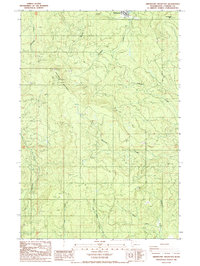
1986 Map of Abernathy Mountain
USGS Topo · Published 1986About this map
Ryderwood sits at the northern edge of this drainage-rich landscape in Cowlitz County, where timber and terrain dictate the local geography. The area is defined by the high point of Abernathy Mountain and its namesake ridge, which serves as a significant divide for numerous watercourses. To the north and west, Stillwater Creek and Becker Creek flow toward the valley, while the southern slopes feed a complex network of streams including Germany Creek, Coal Creek, and East Fork Coal Creek.
Find a feature on this map
18 named features on this map. Tap any name to fly to it.
Don’t see what you’re looking for? This feature index may not catch every label — zoom into the map to look around manually.
Map Details
Editions of this 1986 Abernathy Mountain Map
This is the sole edition of this map. No revisions or reprints were ever made.
Other maps of this area

1919 · Mayger
USGS Topo · 1:62,500

1921 · Kalama
USGS Topo · 1:62,500

1941 · Olequa
USGS Topo · 1:62,500

1941 · Clatskanie
USGS Topo · 1:62,500

1952 · Clatskanie
USGS Topo · 1:62,500

1953 · Hoquiam
USGS Topo · 1:250,000

1953 · Castle Rock
USGS Topo · 1:62,500

1953 · Ryderwood
USGS Topo · 1:62,500
1953 · Kelso
USGS Topo · 1:24,000

1957 · Hoquiam
USGS Topo · 1:250,000