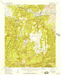
1953 Map of Abiquiu
USGS Topo · Published 1957About this map
Rio Chama flows through the heart of this Northern New Mexico landscape, a region defined by ancient Spanish land grants and deep canyon topography. The settlement of Abiquiu sits at the nexus of several historic territories, including the Town of Abiquiu Grant and the Juan Jose Lobato Grant. Small agricultural communities like Cañones, with its Cañones Grade School and the Capilla de San Miguel, are tucked away in the draws of the Santa Fe National Forest. The map documents a complex network of traditional water management via the Trujillo Ditch and other unnamed ditches that divert water from the river to the valley floor.
Find a feature on this map
111 named features on this map. Tap any name to fly to it.
Don’t see what you’re looking for? This feature index may not catch every label — zoom into the map to look around manually.
Map Details
Editions of this 1953 Abiquiu Map
2 editions found
Other maps of this area

1890 · Jemes
USGS Topo · 1:125,000

1892 · Jemes
USGS Topo · 1:125,000

1892 · Santa Clara
USGS Topo · 1:125,000

1909 · Gallina
USGS Topo · 1:125,000

1918 · Abiquiu
USGS Topo · 1:125,000

1937 · Jemez Springs
USGS Topo · 1:48,000

1944 · Jemez Springs
USGS Topo · 1:62,500

1952 · Valle Toledo
USGS Topo · 1:24,000

1952 · Jemez Springs
USGS Topo · 1:62,500

1952 · Puye
USGS Topo · 1:24,000