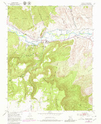
1953 Map of Abiquiu
USGS Topo · Published 1980About this map
Rio Chama flows through a landscape defined by historic land grants and traditional New Mexican settlements. This mid-century survey, with revisions from the late 1970s, captures the cultural layout of the Abiquiu area, including the Plaza Colorada Grant and Plaza Blanca Grant. The map details a complex irrigation network of ditches serving agricultural areas near Rancho de Abiquiu and smaller hamlets like El Curuco and La Careda. The transition from the river valley to the high elevations of Lobato Mesa and Abiquiu Mesa is starkly illustrated. Beyond the established town sites, the map records more isolated points of interest such as the Landing Strip and natural features like Agua Caliente and Los Ojitos de Agua Salada Dañosa, reflecting the area's geological variety.
Find a feature on this map
40 named features on this map. Tap any name to fly to it.
Don’t see what you’re looking for? This feature index may not catch every label — zoom into the map to look around manually.
Map Details
Editions of this 1953 Abiquiu Map
Other maps of this area

1918 · Abiquiu
USGS Topo · 1:125,000

1953 · Canones
USGS Topo · 1:24,000

1953 · Chili
USGS Topo · 1:24,000

1953 · Abiquiu
USGS Topo · 1:24,000

1953 · Medanales
USGS Topo · 1:24,000

1953 · Vallecitos
USGS Topo · 1:24,000

1953 · Polvadera Peak
USGS Topo · 1:24,000

1953 · El Rito
USGS Topo · 1:24,000

1953 · Canjilon SE
USGS Topo · 1:24,000

1953 · Ghost Ranch
USGS Topo · 1:24,000