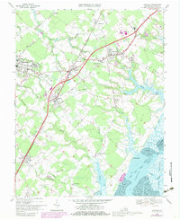
1968 Map of Accomac
USGS Topo · Published 1980About this map
The Accomac landscape of the late 1960s and late 1970s is defined by its deep saltwater inlets and a string of historic settlements along the interior rail corridor. The Virginia and Maryland railroad serves as the spine for community growth, connecting Tasley, Onley, and Melfa. This transportation network is mirrored by the long-established Bayside Road and Seaside Road, which navigate the headwaters of numerous tidal creeks. On the western side, the dense settlement of Onancock overlooks its namesake creek, while the eastern shore is dominated by the intricate marshlands of Burtons Bay and the Inside Passage. Local history is anchored by rural landmarks like the Walker Sch and the Fairgrounds, while the numerous Cem and Joynes Cem sites offer tangible links for genealogical research across the necks of land like Baylys Neck and Custis Neck.
Find a feature on this map
61 named features on this map. Tap any name to fly to it.
Don’t see what you’re looking for? This feature index may not catch every label — zoom into the map to look around manually.
Map Details
Editions of this 1968 Accomac Map
Other maps of this area

1903 · Crisfield
USGS Topo · 1:62,500

1920 · Crisfield
USGS Topo · 1:62,500

1931 · Accomac
USGS Topo · 1:48,000

1935 · Accomac
USGS Topo · 1:62,500

1942 · Chesconessex
USGS Topo · 1:31,680

1942 · Mappsville
USGS Topo · 1:24,000

1942 · Parksley
USGS Topo · 1:24,000

1943 · Pungoteague
USGS Topo · 1:31,680

1943 · Parksley
USGS Topo · 1:31,680

1943 · Mappsville
USGS Topo · 1:31,680