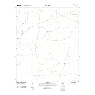
2010 Map of Acme
USGS Topo · Published 2010About this map
Acme and its industrial landscape sit within a transition of the Chaves County high plains, where the Pecos River carves the western edge of this territory. The presence of the Plaster Plant and multiple extraction sites like Jesse E Hite Pit and Hurford Pit indicate a landscape defined by gypsum or mineral production. In the early 21st century, these operations coexisted with established family holdings such as Kitchen Ranch, Smith Ranch, and Dallas Ranch, reflecting the enduring cattle and ranching heritage of the Pecos Valley. Genealogy researchers may find significance in the Frazier Cemetery, located near the northern transport routes. Landmarks like the Bob Crosby Bridge and the winding Bob Crosby Draw anchor the geography around the river, while solitary features like North Windmill and South Windmill mark the essential water infrastructure required for survival in this arid New Mexico environment.
Find a feature on this map
18 named features on this map. Tap any name to fly to it.
Don’t see what you’re looking for? This feature index may not catch every label — zoom into the map to look around manually.
Map Details
Editions of this 2010 Acme Map
This is the sole edition of this map. No revisions or reprints were ever made.
Other maps of this area

1949 · L-E Ranch
USGS Topo · 1:24,000

1950 · Comanche Spring
USGS Topo · 1:24,000

1950 · Bitter Lake
USGS Topo · 1:24,000

1955 · Roswell
USGS Topo · 1:250,000

1958 · Roswell
USGS Topo · 1:250,000

1962 · Roswell
USGS Topo · 1:250,000

1962 · Eightmile Draw
USGS Topo · 1:24,000
1962 · Bitter Lake
USGS Topo · 1:24,000

1962 · Acme
USGS Topo · 1:24,000
1962 · Melena
USGS Topo · 1:24,000