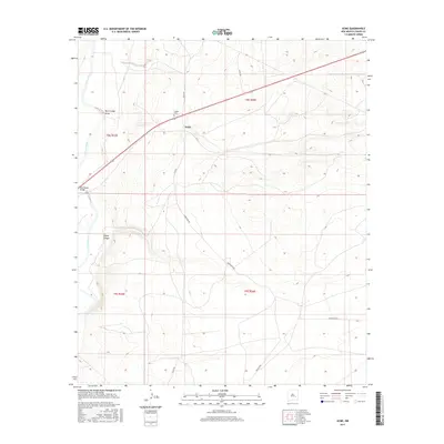
2017 Map of Acme
USGS Topo · Published 2017About this map
The Pecos River carves through the western edge of this Chaves County landscape, where the settlement of Acme sits along a primary corridor in the high plains. This 2017 topographic study documents a region defined by its drainage patterns and rural infrastructure, most notably where the Bob Crosby Draw and Lloyds Canyon descend toward the river valley. The Bob Crosby Bridge provides a vital crossing point, while the presence of the Frazier Cem north of the main settlement offers a specific point of interest for genealogists and local historians tracking family roots in the area. A network of named ranch roads, including Aztec Rd and Magdalena Rd, reveals the enduring survey lines and land use patterns of the eastern New Mexico territory.
Find a feature on this map
15 named features on this map. Tap any name to fly to it.
Don’t see what you’re looking for? This feature index may not catch every label — zoom into the map to look around manually.
Map Details
Editions of this 2017 Acme Map
This is the sole edition of this map. No revisions or reprints were ever made.
Other maps of this area

1949 · L-E Ranch
USGS Topo · 1:24,000

1950 · Comanche Spring
USGS Topo · 1:24,000

1950 · Bitter Lake
USGS Topo · 1:24,000

1955 · Roswell
USGS Topo · 1:250,000

1958 · Roswell
USGS Topo · 1:250,000

1962 · Roswell
USGS Topo · 1:250,000

1962 · Eightmile Draw
USGS Topo · 1:24,000
1962 · Bitter Lake
USGS Topo · 1:24,000

1962 · Acme
USGS Topo · 1:24,000
1962 · Melena
USGS Topo · 1:24,000