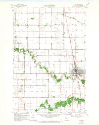
1965 Map of Ada
USGS Topo · Published 1967About this map
The city of Ada serves as the focal point of this mid-1960s survey, situated at the intersection of the Great Northern railroad and several primary local thoroughfares. The landscape is defined by the highly managed hydrology of the Red River Valley, characterized by a dense network of engineered waterways such as State Ditch No 68 and County Ditch No 69, which augment the natural flows of the Marsh River and the Wild Rice River. These drainage systems reflect the area's intensive agricultural development across the townships of Anthony, Pleasant View, Hegne, and McDonaldsville. Beyond the city limits, landmarks like the Fairground and Larson Landing Field suggest a community well-established in its regional role, while the Petri Cem and rural Townhall near Hadler provide specific points of interest for those tracing family roots in Norman County.
Find a feature on this map
27 named features on this map. Tap any name to fly to it.
Don’t see what you’re looking for? This feature index may not catch every label — zoom into the map to look around manually.
Map Details
Editions of this 1965 Ada Map
This is the sole edition of this map. No revisions or reprints were ever made.
Other maps of this area

1918 · Twin Valley
USGS Topo · 1:62,500

1918 · Ulen
USGS Topo · 1:62,500

1924 · Ada
USGS Topo · 1:62,500

1952 · Grand Forks
USGS Topo · 1:250,000

1956 · Grand Forks
USGS Topo · 1:250,000

1965 · Lockhart
USGS Topo · 1:24,000

1965 · Anthony
USGS Topo · 1:24,000
1965 · Ada NW
USGS Topo · 1:24,000

1965 · Twin Valley SW
USGS Topo · 1:24,000

1965 · Twin Valley NW
USGS Topo · 1:24,000