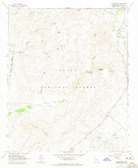
1964 Map of Adams Mesa
USGS Topo · Published 1965About this map
Adams Mesa and the undulating desert terrain of The Rolls dominate this mid-century survey of the Arizona wilderness. Located within the Tonto National Forest, the landscape is defined by its arid hydrology, featuring a network of livestock and wildlife water sources such as Agua Chiquita Spring, Jana Gordo Well, and the Black Mesa Tanks. These scattered water points were vital for the seasonal grazing activities suggested by the presence of Sheep Camp and various cattle-related infrastructure like the Sheep Mesa.
Find a feature on this map
30 named features on this map. Tap any name to fly to it.
Don’t see what you’re looking for? This feature index may not catch every label — zoom into the map to look around manually.
Map Details
Editions of this 1964 Adams Mesa Map
2 editions found
Other maps of this area

1904 · Ft. McDowell
USGS Topo · 1:62,500

1906 · Ft. McDowell
USGS Topo · 1:62,500

1907 · Roosevelt
USGS Topo · 1:125,000

1909 · Four Peaks
USGS Topo · 1:125,000

1912 · Roosevelt
USGS Topo · 1:125,000

1930 · Cave Creek
USGS Topo · 1:125,000

1939 · Cave Creek
USGS Topo · 1:125,000

1954 · Mesa
USGS Topo · 1:250,000

1957 · Mesa
USGS Topo · 1:250,000

1958 · Mesa
USGS Topo · 1:250,000