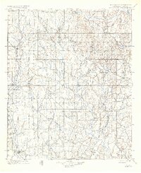
1901 Map of Addington
USGS Topo · Published 1937About this map
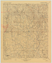
The Chisholm Trail cuts a vertical path through this portion of the Chickasaw Nation, tracing a historic cattle route through a landscape defined by the drainage of Mud Creek and its many forks. This survey, conducted just before the turn of the century, captures the region's transition from open range to a structured rail economy. The Chicago Rock Island and Pacific RR parallels the old trail to the west, anchoring settlements like Addington and Comanche. Near Addington, the presence of the Stock Yards underscores the continued importance of the livestock trade. Further east, the terrain becomes more complex as it approaches the Old Indian Territory Boundary Line. Small communities such as Cornish, Loco, and Woolsey are scattered throughout the interior, connected by primitive routes like the Duncan and Davis Road. From the heights of Monument Hill, the survey reveals a network of watercourses, including Beaver Creek and Wildhorse Creek, that dictated the placement of early homesteads and ranches.
Find a feature on this map
46 named features on this map. Tap any name to fly to it.
Don’t see what you’re looking for? This feature index may not catch every label — zoom into the map to look around manually.
Map Details
Editions of this 1901 Addington Map
6 editions found
Other maps of this area

1898 · Pauls Valley
USGS Topo · 1:125,000

1901 · Addington
USGS Topo · 1:125,000

1901 · Ardmore
USGS Topo · 1:125,000

1902 · Gainesville
USGS Topo · 1:125,000

1902 · Pauls Valley
USGS Topo · 1:125,000

1902 · Rush Springs
USGS Topo · 1:125,000

1905 · Montague
USGS Topo · 1:125,000

1918 · Ardmore
USGS Topo · 1:125,000

1943 · Gainesville
USGS Topo · 1:125,000

1949 · Nellie
USGS Topo · 1:62,500