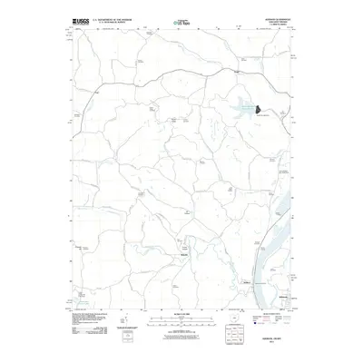
2011 Map of Addison
USGS Topo · Published 2011About this map
Addison and the surrounding riverfront of the Ohio River appear in this 2011 survey, showing a landscape defined by its proximity to the water and its agricultural and industrial heritage. The Addison Post Office serves the immediate riverside community, while family-named landings such as Machir Landing and Berrys Landing point to the historic commerce and river access that sustained this region for generations. Inland, the terrain is marked by numerous small stream valleys, including Campaign Creek and Kyger Creek, which are dotted with old family burial grounds like Van Zant Cemetery, Halfhill Cemetery, and the Rife Cemetery. Modern industrial footprints are visible near the river, notably the Gavin Fly Ash Impoundment and the Gavin Fly Ash Dam. Small settlements like Bulaville and Kyger remain connected by a network of winding local roads, such as Bulaville Pike and Africa Rd, maintaining the rural character of the West Virginia and Ohio borderlands.
Find a feature on this map
88 named features on this map. Tap any name to fly to it.
Don’t see what you’re looking for? This feature index may not catch every label — zoom into the map to look around manually.
Map Details
Editions of this 2011 Addison Map
This is the sole edition of this map. No revisions or reprints were ever made.
Other maps of this area

1905 · Wilkesville
USGS Topo · 1:62,500

1906 · Bidwell
USGS Topo · 1:62,500

1907 · Pomeroy
USGS Topo · 1:62,500

1908 · Bidwell
USGS Topo · 1:62,500

1908 · Point Pleasant
USGS Topo · 1:62,500

1908 · Wilkesville
USGS Topo · 1:62,500

1926 · Point Pleasant
USGS Topo · 1:62,500

1929 · Point Pleasant
USGS Topo · 1:62,500

1947 · Columbus
USGS Topo · 1:250,000

1957 · Beech Hill
USGS Topo · 1:24,000