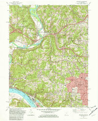
1982 Map of Addyston
USGS Topo · Published 1982About this map
The Great Miami River and Ohio River converge at the southwestern edge of this 1982 map, defining a landscape of steep river bluffs and fertile bottomlands. These river corridors have long shaped the settlement of Hamilton County, visible here in the dense arrangement of communities like Addyston, Cleves, and North Bend. The industrial and transit heritage of the region is evident through the Chessie System tracks hugging the riverbank and the numerous Gravel Pits and quarries dotting the valley floor. To the north, Miamitown remains a central node where the river meets early road networks, flanked by the Miamitown Airport and the Miami Whitewater Forest. The interior terrain is a network of ridges and creeks, such as Buffalo Ridge and Taylor Creek, where suburban growth from Cincinnati pushes westward into Bridgetown and Mack. Local history is preserved in landmarks like the Miamitown Cem and schools such as Diamond Oaks Voc Sch.
Find a feature on this map
60 named features on this map. Tap any name to fly to it.
Don’t see what you’re looking for? This feature index may not catch every label — zoom into the map to look around manually.
Map Details
Editions of this 1982 Addyston Map
3 editions found
Other maps of this area

1914 · West Cincinnati
USGS Topo · 1:62,500

1915 · Lawrenceburg
USGS Topo · 1:48,000

1915 · Harrison
USGS Topo · 1:48,000

1915 · Hamilton
USGS Topo · 1:62,500

1917 · Hamilton
USGS Topo · 1:62,500

1928 · Lawrenceburg
USGS Topo · 1:62,500

1932 · Lawrenceburg
USGS Topo · 1:62,500

1943 · Hooven
USGS Topo · 1:24,000

1943 · Lawrenceburg
USGS Topo · 1:24,000

1950 · Covington
USGS Topo · 1:24,000