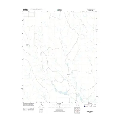
2012 Map of Adobe Creek
USGS Topo · Published 2012About this map
Turkey Track Ranch anchors this portion of the Texas Panhandle, occupying a landscape defined by the drainage systems of the Canadian River. The terrain is marked by the seasonal flow of Adobe Cr and Bent Cr, which carve through the high plains toward the river valley in the south. This 2012 survey illustrates the modern layout of these historic ranching lands, including the Turkey Track Ranch Reservoir and the network of county roads like Co RD 23 that provide access through the open country. To the west, Waters Canyon provides a distinct break in the topography, reflecting the erosive forces typical of the Hutchinson County region. The map serves as a detailed record of land use and water management in a part of Texas where the economy remains deeply tied to large-scale cattle operations and the natural hydrology of the plains.
Find a feature on this map
11 named features on this map. Tap any name to fly to it.
Don’t see what you’re looking for? This feature index may not catch every label — zoom into the map to look around manually.
Map Details
Editions of this 2012 Adobe Creek Map
This is the sole edition of this map. No revisions or reprints were ever made.
Other maps of this area

1953 · Plemons
USGS Topo · 1:24,000

1953 · Stinnett Station
USGS Topo · 1:24,000

1954 · Perryton
USGS Topo · 1:250,000

1954 · Amarillo
USGS Topo · 1:250,000

1958 · Perryton
USGS Topo · 1:250,000

1958 · Amarillo
USGS Topo · 1:250,000

1971 · Adobe Creek SW
USGS Topo · 1:24,000

1971 · Garden Springs
USGS Topo · 1:24,000

1971 · Adobe Creek SE
USGS Topo · 1:24,000

1973 · Spearman SE
USGS Topo · 1:24,000