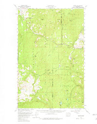
1958 Map of Aeneas
USGS Topo · Published 1981About this map
Old Wauconda and the settlement of Aeneas define the human landscape of this 1958 survey, where the high-altitude terrain of the Okanogan Highlands meets the industrial history of the Republic Mining District. Located along the border of the Okanogan Co Ferry Co, the map reveals a network of gold and silver mining operations concentrated in the northeast corner, including the Knob Hill Mine, Tom Thumb Mine, and Flag Hill Mines.
Find a feature on this map
56 named features on this map. Tap any name to fly to it.
Don’t see what you’re looking for? This feature index may not catch every label — zoom into the map to look around manually.
Map Details
Editions of this 1958 Aeneas Map
3 editions found

Other maps of this area

1902 · Osoyoos
USGS Topo · 1:125,000

1904 · Osoyoos
USGS Topo · 1:125,000

1904 · Republic
USGS Topo · 1:125,000

1948 · Curlew
USGS Topo · 1:62,500

1948 · Republic
USGS Topo · 1:62,500

1951 · Wauconda
USGS Topo · 1:62,500

1951 · Curlew
USGS Topo · 1:62,500

1951 · Bodie Mountain
USGS Topo · 1:62,500

1951 · Republic
USGS Topo · 1:62,500

1952 · Disautel
USGS Topo · 1:62,500