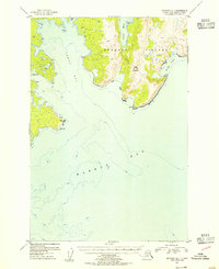
1953 Map of Afognak A-1
USGS Topo · Published 1955About this map
Afognak Island stands as a rugged maritime landscape in the early 1950s, dominated by the towering Edge Mountain and a complex network of deep-water inlets. This topographic survey captures the eastern shoreline where Izhut Bay and Marmot Bay converge, revealing a coastline defined by prominent landmarks like Peril Cape and Pillar Cape. The entire landmass is contained within the Chugach National Forest, illustrating a wilderness shaped by its proximity to the sea rather than industrial or residential development. Notable features such as Saposa Bay and King Cove offer insight into the island's natural harbors and the navigational hazards of the Alaska-Third Judicial Division. The lack of named roads or settlements emphasizes the remote, untouched character of the archipelago during this era of post-war exploration.
Find a feature on this map
28 named features on this map. Tap any name to fly to it.
Don’t see what you’re looking for? This feature index may not catch every label — zoom into the map to look around manually.
Map Details
Editions of this 1953 Afognak A-1 Map
This is the sole edition of this map. No revisions or reprints were ever made.
Other maps of this area

1949 · Kodiak D-2
USGS Topo · 1:63,360

1949 · Kodiak D-1
USGS Topo · 1:63,360

1951 · Kodiak D-1
USGS Topo · 1:63,360

1951 · Kodiak D-2
USGS Topo · 1:63,360

1952 · Kodiak
USGS Topo · 1:250,000

1952 · Afognak
USGS Topo · 1:250,000

1952 · Afognak A-1
USGS Topo · 1:63,360

1952 · Afognak A-2
USGS Topo · 1:63,360

1952 · Afognak B-2
USGS Topo · 1:63,360

1952 · Afognak B-1
USGS Topo · 1:63,360