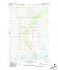
1951 Map of Afognak D-6
USGS Topo · Published 1983About this map
The Douglas River winds through this northern reach of the Alaska Peninsula, a landscape defined by its protected status under the Katmai National Park and Katmai Wilderness designations. The map, based on 1951 aerial photography and updated in 1983, shows a territory of high elevations and drainage patterns largely untouched by permanent settlement or road infrastructure. A significant portion of the southeastern sector is dominated by the massif of Fourpeaked Mountain, which rises as a primary navigational landmark. The presence of the Wilderness Boundary reflects late-20th-century conservation efforts established by the Alaska National Interest Lands Conservation Act. This survey preserves a view of the Kenai Peninsula Borough's western margins at a time when the federal government was formalizing the preservation of these coastal watersheds and volcanic peaks.
Find a feature on this map
5 named features on this map. Tap any name to fly to it.
Don’t see what you’re looking for? This feature index may not catch every label — zoom into the map to look around manually.
Map Details
Editions of this 1951 Afognak D-6 Map
3 editions found
Other maps of this area

1948 · Mt Katmai
USGS Topo · 1:250,000

1951 · Mt Katmai
USGS Topo · 1:250,000

1951 · Afognak C-6
USGS Topo · 1:63,360
1951 · Afognak C-5
USGS Topo · 1:63,360

1951 · Mount Katmai D-1
USGS Topo · 1:63,360

1951 · Iliamna A-3
USGS Topo · 1:63,360

1951 · Iliamna A-1 and A-2
USGS Topo · 1:63,360

1951 · Mount Katmai C-1
USGS Topo · 1:63,360

1951 · Afognak D-5
USGS Topo · 1:63,360

1951 · Afognak D-6
USGS Topo · 1:63,360