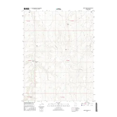
2017 Map of Agency Draw NW
USGS Topo · Published 2017About this map
Little Pack Mountain dominates this high-desert landscape in Uintah County, where the terrain is defined by a dense network of deeply carved canyons and seasonal watercourses. The drainage patterns of the region are anchored by Hill Creek, which winds through the western portion of the map, while Green Canyon and East Squaw Canyon cut through the rugged central highlands. This 2017 survey reveals the infrastructure of a remote wilderness area, showing the JP Man and Agency Complex roads as they navigate the ridges and basins. The map illustrates how human activity, marked by these specific access routes, interacts with the complex topography of the Little Pack Mountain area, providing a detailed look at the hydrology and land management boundaries of the eastern Utah desert.
Find a feature on this map
19 named features on this map. Tap any name to fly to it.
Don’t see what you’re looking for? This feature index may not catch every label — zoom into the map to look around manually.
Map Details
Editions of this 2017 Agency Draw NW Map
This is the sole edition of this map. No revisions or reprints were ever made.
Other maps of this area

1885 · East Tavaputs
USGS Topo · 1:250,000

1953 · Nutters Hole
USGS Topo · 1:62,500

1953 · Firewater Canyon
USGS Topo · 1:62,500

1956 · Grand Junction
USGS Topo · 1:250,000

1959 · Grand Junction
USGS Topo · 1:250,000

1960 · Grand Junction
USGS Topo · 1:250,000

1962 · Grand Junction
USGS Topo · 1:250,000

1964 · Grand Junction
USGS Topo · 1:250,000

1965 · Grand Junction
USGS Topo · 1:250,000
1966 · Agency Draw NE
USGS Topo · 1:24,000