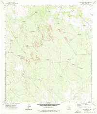
1972 Map of Agua Nueva NW
USGS Topo · Published 1975About this map
The arid ranchlands of Jim Hogg County are defined here by an extensive network of water infrastructure and energy extraction during the early 1970s. The landscape is dotted with named windmills that serve as vital landmarks for cattle operations, including Santo Domingo Windmill, Leoncitos Windmill, and Casa Blanca Windmill. These features, alongside larger holdings like Weil Ranch and Venada Ranch, illustrate the historical reliance on groundwater in this part of South Texas.
Find a feature on this map
35 named features on this map. Tap any name to fly to it.
Don’t see what you’re looking for? This feature index may not catch every label — zoom into the map to look around manually.
Map Details
Editions of this 1972 Agua Nueva NW Map
2 editions found
Other maps of this area

1938 · Agua Nueva
USGS Topo · 1:62,500

1938 · Cuevitas
USGS Topo · 1:62,500

1939 · Randado
USGS Topo · 1:62,500

1940 · Randado
USGS Topo · 1:62,500

1949 · Mc Allen
USGS Topo · 1:250,000

1954 · McAllen
USGS Topo · 1:250,000

1956 · Laredo
USGS Topo · 1:250,000

1957 · Mc Allen
USGS Topo · 1:250,000

1962 · McAllen
USGS Topo · 1:250,000
1972 · San Pablo Ranch
USGS Topo · 1:24,000